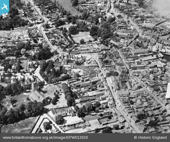
EPW013329 ENGLAND (1925). Fore Street and environs, Hertford, 1925. This image has been produced from a copy-negative.
    © Copyright OpenStreetMap contributors and licensed by the OpenStreetMap Foundation. 2025. Cartography is licensed as CC BY-SA.
  
Nearby Images (5)
Details
| Title | [EPW013329] Fore Street and environs, Hertford, 1925. This image has been produced from a copy-negative. | 
| Reference | EPW013329 | 
| Date | July-1925 | 
| Link | |
| Place name | HERTFORD | 
| Parish | HERTFORD | 
| District | |
| Country | ENGLAND | 
| Easting / Northing | 532660, 212532 | 
| Longitude / Latitude | -0.076099518713196, 51.79523461119 | 
| National Grid Reference | TL327125 | 
Pins
Be the first to add a comment to this image!
 
             
  ![[EPW013329] Fore Street and environs, Hertford, 1925. This image has been produced from a copy-negative.](http://britainfromabove.org.uk/sites/all/libraries/aerofilms-images/public/100x100/EPW/013/EPW013329.jpg) 
  
                                          ![[EAW022370] Hertford Castle and the town, Hertford, 1949](http://britainfromabove.org.uk/sites/all/libraries/aerofilms-images/public/100x100/EAW/022/EAW022370.jpg) 
 ![[EPW022368] The town centre, Hertford, 1928](http://britainfromabove.org.uk/sites/all/libraries/aerofilms-images/public/100x100/EPW/022/EPW022368.jpg) 
 ![[EAW022372] Bircherley Green and the town, Hertford, 1949](http://britainfromabove.org.uk/sites/all/libraries/aerofilms-images/public/100x100/EAW/022/EAW022372.jpg) 
 ![[EPW013328] St Andrew Street and environs, Hertford, 1925. This image has been produced from a copy-negative.](http://britainfromabove.org.uk/sites/all/libraries/aerofilms-images/public/100x100/EPW/013/EPW013328.jpg)