
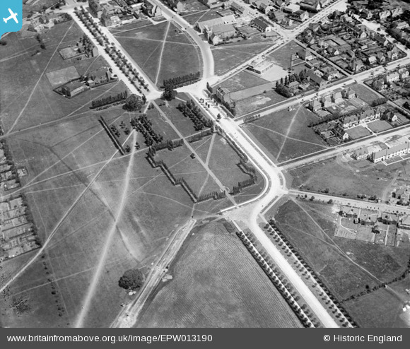
EPW013190 ENGLAND (1925). Broadway, Letchworth Garden City, 1925
© Copyright OpenStreetMap contributors and licensed by the OpenStreetMap Foundation. 2026. Cartography is licensed as CC BY-SA.
Nearby Images (4)
EPW013190

EAW041989

EAW041988

EAW034705

Details
| Title | [EPW013190] Broadway, Letchworth Garden City, 1925 |
| Reference | EPW013190 |
| Date | June-1925 |
| Link | |
| Place name | LETCHWORTH GARDEN CITY |
| Parish | LETCHWORTH GARDEN CITY |
| District | |
| Country | ENGLAND |
| Easting / Northing | 521618, 232318 |
| Longitude / Latitude | -0.22917375161179, 51.975574424702 |
| National Grid Reference | TL216323 |
Pins

Roscoe |
Tuesday 9th of January 2018 09:41:43 PM | |
|
Roscoe |
Tuesday 9th of January 2018 09:41:09 PM | |
|
Roscoe |
Tuesday 9th of January 2018 09:40:09 PM | |
|
Roscoe |
Tuesday 9th of January 2018 09:38:57 PM | |
|
Roscoe |
Tuesday 9th of January 2018 09:36:09 PM | |
|
Roscoe |
Saturday 16th of November 2013 04:34:19 PM | |
|
Roscoe |
Saturday 16th of November 2013 04:33:39 PM | |
|
Roscoe |
Saturday 16th of November 2013 04:32:38 PM | |
|
Roscoe |
Saturday 16th of November 2013 04:13:10 PM | |
|
Roscoe |
Saturday 16th of November 2013 03:57:36 PM | |
|
Roscoe |
Saturday 16th of November 2013 03:56:11 PM | |
|
Ralphy |
Tuesday 25th of June 2013 08:30:11 PM | |
Formerly the Madonna School |
Roscoe |
Saturday 16th of November 2013 04:07:05 PM |
|
Roscoe |
Saturday 11th of May 2013 03:25:56 PM | |
|
Roscoe |
Saturday 11th of May 2013 03:25:08 PM | |

Joe |
Saturday 23rd of February 2013 09:04:44 PM |
User Comment Contributions
Note the absence of any pubs! Letchworth was built as a temperance town, so there were no public houses! There was a hotel that served alcohol, but you had to be a resident and alcohol was only served with meals. |
Sweet Pete |
Saturday 9th of April 2016 04:57:16 PM |

Thanks for the tip, BruceR! Here's the image. I find it shows particularly well how people still prefer the direct way to all the planned rectangular road works - you can see the paths they made as well as the actual streets! |
Sandra Brauer |
Thursday 29th of November 2012 01:18:46 PM |
Indeed, fine example of the human temperament and the planners art not fitting too well. There was much further development, including completing the elongated roundabout seen in the centre of the picture. It is evident in modern aerial pictures of Letchworth, although the "cutting the corner" footpaths have gone. |

Maurice |
Thursday 22nd of November 2012 08:15:30 AM |
There are a couple of planned factory towns on the Wirral. Port Sunlight is the best known, it still stands next to the Lever Brothers factory, now Unilever. I think you can just see it in the top right of this picture. http://www.britainfromabove.org.uk/image/epw025167 Also Prices Candles had a workers village, which can be seen here. .. http://www.britainfromabove.org.uk/image/epw021620 |
BruceR |
Thursday 29th of November 2012 01:18:46 PM |