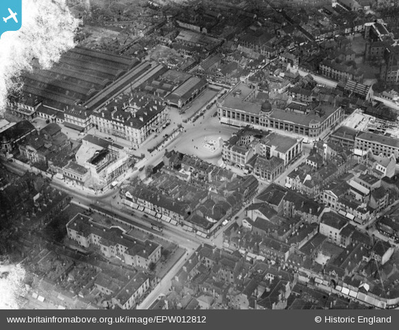
EPW012812 ENGLAND (1925). Paragon Square, Kingston upon Hull, 1925
© Copyright OpenStreetMap contributors and licensed by the OpenStreetMap Foundation. 2026. Cartography is licensed as CC BY-SA.
Nearby Images (8)
Details
| Title | [EPW012812] Paragon Square, Kingston upon Hull, 1925 |
| Reference | EPW012812 |
| Date | May-1925 |
| Link | |
| Place name | KINGSTON UPON HULL |
| Parish | |
| District | |
| Country | ENGLAND |
| Easting / Northing | 509298, 428779 |
| Longitude / Latitude | -0.34252363106837, 53.743693470975 |
| National Grid Reference | TA093288 |
Pins

Hargow |
Thursday 9th of May 2013 10:44:35 AM | |

HullPaul |
Monday 27th of August 2012 06:47:54 PM | |
Ex St. Helens RT type bus in view. Bought as a stop gap as after trolley buses were scrapped in haste and re-placement Atlantians were slow to arrive. |

John Wass |
Friday 4th of July 2014 03:29:19 PM |
.jpg)
logic500 |
Wednesday 27th of June 2012 03:09:18 PM | |
.jpg)
logic500 |
Wednesday 27th of June 2012 03:05:39 PM | |
.jpg)
logic500 |
Wednesday 27th of June 2012 03:03:35 PM | |
.jpg)
logic500 |
Wednesday 27th of June 2012 03:02:35 PM |


![[EPW012812] Paragon Square, Kingston upon Hull, 1925](http://britainfromabove.org.uk/sites/all/libraries/aerofilms-images/public/100x100/EPW/012/EPW012812.jpg)
![[EPW036501] Paragon Square, Kingston upon Hull, 1931](http://britainfromabove.org.uk/sites/all/libraries/aerofilms-images/public/100x100/EPW/036/EPW036501.jpg)
![[EPW012814] Paragon Square, Kingston upon Hull, 1925. This image has been produced from a print.](http://britainfromabove.org.uk/sites/all/libraries/aerofilms-images/public/100x100/EPW/012/EPW012814.jpg)
![[EPW010787] Paragon Square and the city centre, Kingston upon Hull, 1924. This image has been produced from a print.](http://britainfromabove.org.uk/sites/all/libraries/aerofilms-images/public/100x100/EPW/010/EPW010787.jpg)
![[EPW012808] Paragon Square, Kingston upon Hull, 1925](http://britainfromabove.org.uk/sites/all/libraries/aerofilms-images/public/100x100/EPW/012/EPW012808.jpg)
![[EAW028628] Queen's Gardens and the city centre, Kingston upon Hull, from the south-west, 1950](http://britainfromabove.org.uk/sites/all/libraries/aerofilms-images/public/100x100/EAW/028/EAW028628.jpg)
![[EAW028629] Paragon Railway Station and the city centre, Kingston upon Hull, 1950](http://britainfromabove.org.uk/sites/all/libraries/aerofilms-images/public/100x100/EAW/028/EAW028629.jpg)
![[EAW028630] St Stephen's Church, the Bus Depot and the city centre, Kingston upon Hull, 1950](http://britainfromabove.org.uk/sites/all/libraries/aerofilms-images/public/100x100/EAW/028/EAW028630.jpg)
