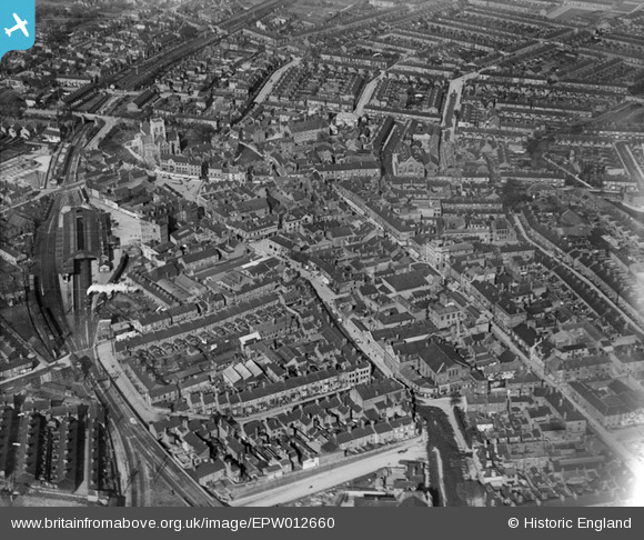
EPW012660 ENGLAND (1925). The town centre, Grimsby, 1925
© Copyright OpenStreetMap contributors and licensed by the OpenStreetMap Foundation. 2026. Cartography is licensed as CC BY-SA.
Nearby Images (5)
Details
| Title | [EPW012660] The town centre, Grimsby, 1925 |
| Reference | EPW012660 |
| Date | 6-May-1925 |
| Link | |
| Place name | GRIMSBY |
| Parish | |
| District | |
| Country | ENGLAND |
| Easting / Northing | 526841, 409276 |
| Longitude / Latitude | -0.084602972499502, 53.564501987794 |
| National Grid Reference | TA268093 |
Pins

Class31 |
Wednesday 11th of May 2016 06:59:04 AM | |

Class31 |
Wednesday 11th of May 2016 06:56:00 AM | |

Class31 |
Wednesday 11th of May 2016 06:50:10 AM | |

Class31 |
Wednesday 11th of May 2016 06:48:47 AM | |

Class31 |
Tuesday 10th of May 2016 11:12:47 PM | |

Class31 |
Tuesday 10th of May 2016 11:08:47 PM | |

Class31 |
Tuesday 10th of May 2016 10:56:11 PM | |

Class31 |
Monday 1st of September 2014 07:42:28 PM | |

Beowolf |
Saturday 28th of June 2014 10:20:44 AM | |

dclc |
Wednesday 27th of June 2012 09:11:30 PM | |

dclc |
Wednesday 27th of June 2012 09:08:53 PM |


![[EPW012660] The town centre, Grimsby, 1925](http://britainfromabove.org.uk/sites/all/libraries/aerofilms-images/public/100x100/EPW/012/EPW012660.jpg)
![[EPW053387] Grimsby Town Railway Station and environs, Grimsby, from the south-east, 1937](http://britainfromabove.org.uk/sites/all/libraries/aerofilms-images/public/100x100/EPW/053/EPW053387.jpg)
![[EPW012667] St James's Church and environs, Grimsby, 1925](http://britainfromabove.org.uk/sites/all/libraries/aerofilms-images/public/100x100/EPW/012/EPW012667.jpg)
![[EPW042805] The Town Railway Station, cattle market and St James' Church, Grimsby, 1933](http://britainfromabove.org.uk/sites/all/libraries/aerofilms-images/public/100x100/EPW/042/EPW042805.jpg)
![[EAW052050] The Osmond and Sons Ltd Moss Road Works, Grimsby, 1953. This image was marked by Aerofilms Ltd for photo editing.](http://britainfromabove.org.uk/sites/all/libraries/aerofilms-images/public/100x100/EAW/052/EAW052050.jpg)