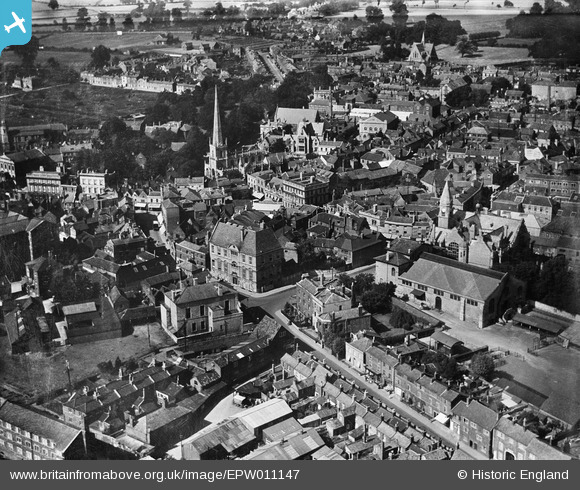
EPW011147 ENGLAND (1924). Market Street and environs, Trowbridge, 1924
© Copyright OpenStreetMap contributors and licensed by the OpenStreetMap Foundation. 2026. Cartography is licensed as CC BY-SA.
Nearby Images (10)
Details
| Title | [EPW011147] Market Street and environs, Trowbridge, 1924 |
| Reference | EPW011147 |
| Date | July-1924 |
| Link | |
| Place name | TROWBRIDGE |
| Parish | TROWBRIDGE |
| District | |
| Country | ENGLAND |
| Easting / Northing | 385619, 157938 |
| Longitude / Latitude | -2.2063883597629, 51.319861730465 |
| National Grid Reference | ST856579 |


![[EPW011147] Market Street and environs, Trowbridge, 1924](http://britainfromabove.org.uk/sites/all/libraries/aerofilms-images/public/100x100/EPW/011/EPW011147.jpg)
![[EPW011148] The Town Hall and Market, Trowbridge, 1924](http://britainfromabove.org.uk/sites/all/libraries/aerofilms-images/public/100x100/EPW/011/EPW011148.jpg)
![[EAW028646] The town centre, Trowbridge, 1950](http://britainfromabove.org.uk/sites/all/libraries/aerofilms-images/public/100x100/EAW/028/EAW028646.jpg)
![[EPW033204] St James's Church and the town centre, Trowbridge, 1930](http://britainfromabove.org.uk/sites/all/libraries/aerofilms-images/public/100x100/EPW/033/EPW033204.jpg)
![[EPW033294] The town, Trowbridge, 1930](http://britainfromabove.org.uk/sites/all/libraries/aerofilms-images/public/100x100/EPW/033/EPW033294.jpg)
![[EPW014684] G.H. Haden and Sons Ltd Engineering Works, the War Memorial and environs, Trowbridge, 1926. This image has been produced from a copy-negative.](http://britainfromabove.org.uk/sites/all/libraries/aerofilms-images/public/100x100/EPW/014/EPW014684.jpg)
![[EPW011146] Wicker Hill, the Home Woollen Mills and environs, Trowbridge, 1924](http://britainfromabove.org.uk/sites/all/libraries/aerofilms-images/public/100x100/EPW/011/EPW011146.jpg)
![[EAW028648] Upper Mills, The Park and the town centre, Trowbridge, 1950](http://britainfromabove.org.uk/sites/all/libraries/aerofilms-images/public/100x100/EAW/028/EAW028648.jpg)
![[EAW028645] County Hall and the town centre, Trowbridge, 1950](http://britainfromabove.org.uk/sites/all/libraries/aerofilms-images/public/100x100/EAW/028/EAW028645.jpg)
![[EPW033207] The town, Trowbridge, from the south-east, 1930](http://britainfromabove.org.uk/sites/all/libraries/aerofilms-images/public/100x100/EPW/033/EPW033207.jpg)


