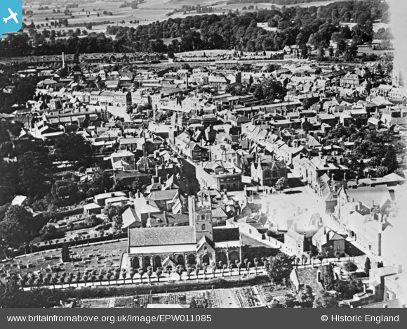
EPW011085 ENGLAND (1924). St John the Baptist's Church and the town centre, Devizes, 1924. This image has been produced from a copy-negative.
© Copyright OpenStreetMap contributors and licensed by the OpenStreetMap Foundation. 2026. Cartography is licensed as CC BY-SA.
Nearby Images (17)
Details
| Title | [EPW011085] St John the Baptist's Church and the town centre, Devizes, 1924. This image has been produced from a copy-negative. |
| Reference | EPW011085 |
| Date | July-1924 |
| Link | |
| Place name | DEVIZES |
| Parish | DEVIZES |
| District | |
| Country | ENGLAND |
| Easting / Northing | 400455, 161378 |
| Longitude / Latitude | -1.9934656662829, 51.350978474953 |
| National Grid Reference | SU005614 |
Pins
Be the first to add a comment to this image!


![[EPW011085] St John the Baptist's Church and the town centre, Devizes, 1924. This image has been produced from a copy-negative.](http://britainfromabove.org.uk/sites/all/libraries/aerofilms-images/public/100x100/EPW/011/EPW011085.jpg)
![[EAW015072] The town, Devizes, 1948](http://britainfromabove.org.uk/sites/all/libraries/aerofilms-images/public/100x100/EAW/015/EAW015072.jpg)
![[EAW015073] Devizes Castle and the town centre, Devizes, 1948](http://britainfromabove.org.uk/sites/all/libraries/aerofilms-images/public/100x100/EAW/015/EAW015073.jpg)
![[EPW011089] The town centre, Devizes, 1924. This image has been produced from a copy-negative.](http://britainfromabove.org.uk/sites/all/libraries/aerofilms-images/public/100x100/EPW/011/EPW011089.jpg)
![[EAW034906] The Market Place, Devizes, 1951](http://britainfromabove.org.uk/sites/all/libraries/aerofilms-images/public/100x100/EAW/034/EAW034906.jpg)
![[EAW034904] The Market Place, Devizes, 1951](http://britainfromabove.org.uk/sites/all/libraries/aerofilms-images/public/100x100/EAW/034/EAW034904.jpg)
![[EPW011084] St John the Baptist's Church and the town, Devizes, 1924. This image has been produced from a copy-negative.](http://britainfromabove.org.uk/sites/all/libraries/aerofilms-images/public/100x100/EPW/011/EPW011084.jpg)
![[EAW034908] The Market Place and town, Devizes, 1951](http://britainfromabove.org.uk/sites/all/libraries/aerofilms-images/public/100x100/EAW/034/EAW034908.jpg)
![[EAW015074] The Market Place, Devizes, 1948](http://britainfromabove.org.uk/sites/all/libraries/aerofilms-images/public/100x100/EAW/015/EAW015074.jpg)
![[EAW034907] Devizes Castle and the town, Devizes, 1951](http://britainfromabove.org.uk/sites/all/libraries/aerofilms-images/public/100x100/EAW/034/EAW034907.jpg)
![[EPW011088] The Market Place, Devizes, 1924. This image has been produced from a copy-negative.](http://britainfromabove.org.uk/sites/all/libraries/aerofilms-images/public/100x100/EPW/011/EPW011088.jpg)
![[EAW015071] Devizes Castle and the Market Place, Devizes, 1948](http://britainfromabove.org.uk/sites/all/libraries/aerofilms-images/public/100x100/EAW/015/EAW015071.jpg)
![[EAW015075] Devizes Castle, Devizes, 1948](http://britainfromabove.org.uk/sites/all/libraries/aerofilms-images/public/100x100/EAW/015/EAW015075.jpg)
![[EAW015076] Devizes Castle, Devizes, 1948](http://britainfromabove.org.uk/sites/all/libraries/aerofilms-images/public/100x100/EAW/015/EAW015076.jpg)
![[EAW034905] Devizes Castle, Devizes, 1951](http://britainfromabove.org.uk/sites/all/libraries/aerofilms-images/public/100x100/EAW/034/EAW034905.jpg)
![[EPW011093] Devizes Castle, Devizes, 1924. This image has been produced from a copy-negative.](http://britainfromabove.org.uk/sites/all/libraries/aerofilms-images/public/100x100/EPW/011/EPW011093.jpg)
![[EPW011086] The Brittox and the town, Devizes, 1924. This image has been produced from a copy-negative.](http://britainfromabove.org.uk/sites/all/libraries/aerofilms-images/public/100x100/EPW/011/EPW011086.jpg)