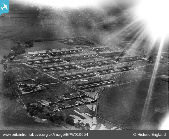
EPW010654 ENGLAND (1924). Linton Colliery Village, Linton, 1924. This image has been affected by flare.
© Copyright OpenStreetMap contributors and licensed by the OpenStreetMap Foundation. 2024. Cartography is licensed as CC BY-SA.
Details
| Title | [EPW010654] Linton Colliery Village, Linton, 1924. This image has been affected by flare. |
| Reference | EPW010654 |
| Date | 14-June-1924 |
| Link | |
| Place name | LINTON |
| Parish | ELLINGTON AND LINTON |
| District | |
| Country | ENGLAND |
| Easting / Northing | 426402, 591292 |
| Longitude / Latitude | -1.5850014207276, 55.215112972237 |
| National Grid Reference | NZ264913 |
Pins
User Comment Contributions
Linton Colliery |
 Dave Brunt |
Monday 1st of July 2013 05:12:52 PM |
Hi Dave, Thanks for spotting this image. The Aerofilms Ltd Register entry is blank for this glass plate! We'll update the catalogue, and post the new data here in due course. Yours, Katy Britain from Above Cataloguing Team Leader |
Katy Whitaker |
Monday 1st of July 2013 05:12:52 PM |
Even knowing that this is Linton Colliery it is still a struggle to understand why.The photo is taken looking south west with the sewage works on the left. |
 Class31 |
Sunday 2nd of June 2013 03:56:14 PM |


![[EPW010654] Linton Colliery Village, Linton, 1924. This image has been affected by flare.](http://britainfromabove.org.uk/sites/all/libraries/aerofilms-images/public/100x100/EPW/010/EPW010654.jpg)
![[EPW010738] Linton Colliery, Linton, 1924](http://britainfromabove.org.uk/sites/all/libraries/aerofilms-images/public/100x100/EPW/010/EPW010738.jpg)
![[EPW010644] The Linton Colliery and environs, Linton, 1924](http://britainfromabove.org.uk/sites/all/libraries/aerofilms-images/public/100x100/EPW/010/EPW010644.jpg)
![[EPW010645] The Linton Colliery and environs, Linton, 1924](http://britainfromabove.org.uk/sites/all/libraries/aerofilms-images/public/100x100/EPW/010/EPW010645.jpg)