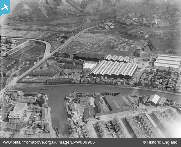
EPW009965 ENGLAND (1924). Timber yards beside the Hackney Cut Navigation, Bow, 1924
© Copyright OpenStreetMap contributors and licensed by the OpenStreetMap Foundation. 2026. Cartography is licensed as CC BY-SA.
Nearby Images (16)
Details
| Title | [EPW009965] Timber yards beside the Hackney Cut Navigation, Bow, 1924 |
| Reference | EPW009965 |
| Date | March-1924 |
| Link | |
| Place name | BOW |
| Parish | |
| District | |
| Country | ENGLAND |
| Easting / Northing | 537415, 184395 |
| Longitude / Latitude | -0.018252709196452, 51.541223837058 |
| National Grid Reference | TQ374844 |
Pins

divadnosae |
Saturday 25th of January 2014 07:49:37 PM | |

divadnosae |
Saturday 25th of January 2014 07:49:13 PM | |

divadnosae |
Saturday 25th of January 2014 07:48:45 PM | |

Chelsea61 |
Wednesday 5th of June 2013 10:45:04 PM | |

Chelsea61 |
Wednesday 5th of June 2013 10:44:35 PM | |

Chelsea61 |
Wednesday 5th of June 2013 10:42:31 PM | |
Surely the stadium wasn't being constructed in 1924 the date given for this photograph? |
 8-2007.JPG)
Keith |
Tuesday 17th of February 2015 04:21:13 PM |


![[EPW009965] Timber yards beside the Hackney Cut Navigation, Bow, 1924](http://britainfromabove.org.uk/sites/all/libraries/aerofilms-images/public/100x100/EPW/009/EPW009965.jpg)
![[EAW022427] The J. Gliksten and Son Ltd timber yard on Carpenter's Road and environs, Old Ford, 1949. This image has been produced from a print marked by Aerofilms Ltd for photo editing.](http://britainfromabove.org.uk/sites/all/libraries/aerofilms-images/public/100x100/EAW/022/EAW022427.jpg)
![[EAW022428] The J. Gliksten and Son Ltd timber yard on Carpenter's Road and environs, Old Ford, 1949. This image has been produced from a print marked by Aerofilms Ltd for photo editing.](http://britainfromabove.org.uk/sites/all/libraries/aerofilms-images/public/100x100/EAW/022/EAW022428.jpg)
![[EAW022430] The J. Gliksten and Son Ltd timber yard on Carpenter's Road and environs, Old Ford, 1949. This image has been produced from a print marked by Aerofilms Ltd for photo editing.](http://britainfromabove.org.uk/sites/all/libraries/aerofilms-images/public/100x100/EAW/022/EAW022430.jpg)
![[EAW022431] The J. Gliksten and Son Ltd timber yard on Carpenter's Road and environs, Stratford, 1949](http://britainfromabove.org.uk/sites/all/libraries/aerofilms-images/public/100x100/EAW/022/EAW022431.jpg)
![[EAW022425] The J. Gliksten and Son Ltd timber yard on Carpenter's Road and environs, Stratford, 1949](http://britainfromabove.org.uk/sites/all/libraries/aerofilms-images/public/100x100/EAW/022/EAW022425.jpg)
![[EAW022429] The J. Gliksten and Son Ltd timber yard on Carpenter's Road and environs, Old Ford, from the west, 1949. This image has been produced from a print marked by Aerofilms Ltd for photo editing.](http://britainfromabove.org.uk/sites/all/libraries/aerofilms-images/public/100x100/EAW/022/EAW022429.jpg)
![[EPW011914] Clarke, Nicholls and Coombs Ltd Clarnico Works beside the Hackney Navigation, Hackney Wick, 1924. This image has been produced from a copy-negative.](http://britainfromabove.org.uk/sites/all/libraries/aerofilms-images/public/100x100/EPW/011/EPW011914.jpg)
![[EPW006777] The Clarnico Works, Bow, 1921](http://britainfromabove.org.uk/sites/all/libraries/aerofilms-images/public/100x100/EPW/006/EPW006777.jpg)
![[EPW009967] Timber yards beside the Hackney Cut Navigation, Bow, 1924](http://britainfromabove.org.uk/sites/all/libraries/aerofilms-images/public/100x100/EPW/009/EPW009967.jpg)
![[EPW006770] The Clarnico Works, Bow, 1921](http://britainfromabove.org.uk/sites/all/libraries/aerofilms-images/public/100x100/EPW/006/EPW006770.jpg)
![[EPW009966] Timber yards beside the Hackney Cut Navigation, Bow, 1924](http://britainfromabove.org.uk/sites/all/libraries/aerofilms-images/public/100x100/EPW/009/EPW009966.jpg)
![[EPW006776] The Clarnico Works, Bow, 1921](http://britainfromabove.org.uk/sites/all/libraries/aerofilms-images/public/100x100/EPW/006/EPW006776.jpg)
![[EPW006772] The Clarnico Works, Hackney Wick, 1921](http://britainfromabove.org.uk/sites/all/libraries/aerofilms-images/public/100x100/EPW/006/EPW006772.jpg)
![[EPW006774] The Clarnico Works, Hackney Wick, 1921](http://britainfromabove.org.uk/sites/all/libraries/aerofilms-images/public/100x100/EPW/006/EPW006774.jpg)
![[EPW006775] The Clarnico Works, Hackney Wick, 1921](http://britainfromabove.org.uk/sites/all/libraries/aerofilms-images/public/100x100/EPW/006/EPW006775.jpg)