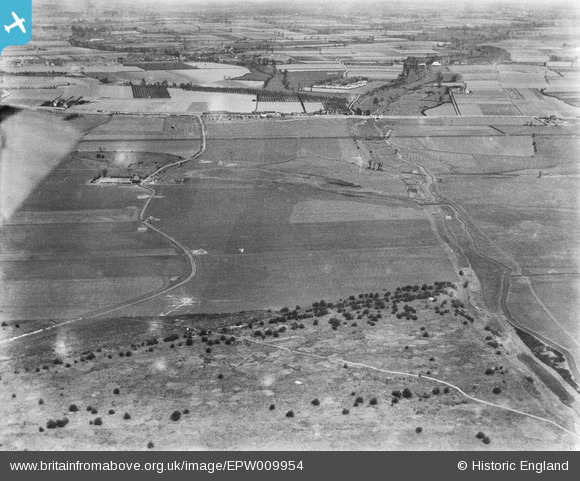
EPW009954 ENGLAND (1924). Havering and Dagenham Marshes beside the Beam River, Dagenham, from the south, 1924
© Copyright OpenStreetMap contributors and licensed by the OpenStreetMap Foundation. 2026. Cartography is licensed as CC BY-SA.
Nearby Images (48)
Details
| Title | [EPW009954] Havering and Dagenham Marshes beside the Beam River, Dagenham, from the south, 1924 |
| Reference | EPW009954 |
| Date | March-1924 |
| Link | |
| Place name | DAGENHAM |
| Parish | |
| District | |
| Country | ENGLAND |
| Easting / Northing | 549726, 181877 |
| Longitude / Latitude | 0.15809134963587, 51.515465022204 |
| National Grid Reference | TQ497819 |
Pins
Be the first to add a comment to this image!


![[EAW053040] The Ford Motor Car Manufactory, Dagenham, 1953](http://britainfromabove.org.uk/sites/all/libraries/aerofilms-images/public/100x100/EAW/053/EAW053040.jpg)
![[EAW022767] The Ford Motor Company Works, Dagenham, 1949. This image has been produced from a print marked by Aerofilms Ltd for photo editing.](http://britainfromabove.org.uk/sites/all/libraries/aerofilms-images/public/100x100/EAW/022/EAW022767.jpg)
![[EAW029516] The Ford Motor Company Works, Dagenham, 1950. This image was marked by Aerofilms Ltd for photo editing.](http://britainfromabove.org.uk/sites/all/libraries/aerofilms-images/public/100x100/EAW/029/EAW029516.jpg)
![[EAW029515] The Ford Motor Company Works, Dagenham, 1950. This image was marked by Aerofilms Ltd for photo editing.](http://britainfromabove.org.uk/sites/all/libraries/aerofilms-images/public/100x100/EAW/029/EAW029515.jpg)
![[EPW046939] The Ford Motor Company Works, Dagenham, from the north, 1935](http://britainfromabove.org.uk/sites/all/libraries/aerofilms-images/public/100x100/EPW/046/EPW046939.jpg)
![[EAW029513] The Ford Motor Company Works, Dagenham, 1950. This image was marked by Aerofilms Ltd for photo editing.](http://britainfromabove.org.uk/sites/all/libraries/aerofilms-images/public/100x100/EAW/029/EAW029513.jpg)
![[EPW061005] The Ford Motor Car Manufactory, Dagenham, 1939](http://britainfromabove.org.uk/sites/all/libraries/aerofilms-images/public/100x100/EPW/061/EPW061005.jpg)
![[EPW062033] The Ford Motor Car Manufactory, Dagenham, 1939](http://britainfromabove.org.uk/sites/all/libraries/aerofilms-images/public/100x100/EPW/062/EPW062033.jpg)
![[EPW055161] The Ford Motor Car Manufactory, Dagenham, 1937](http://britainfromabove.org.uk/sites/all/libraries/aerofilms-images/public/100x100/EPW/055/EPW055161.jpg)
![[EPW055260] The Ford Motor Car Company Works, Dagenham, 1937. This image has been produced from a copy-negative.](http://britainfromabove.org.uk/sites/all/libraries/aerofilms-images/public/100x100/EPW/055/EPW055260.jpg)
![[EAW029521] The Ford Motor Company Works, Dagenham, 1950. This image was marked by Aerofilms Ltd for photo editing.](http://britainfromabove.org.uk/sites/all/libraries/aerofilms-images/public/100x100/EAW/029/EAW029521.jpg)
![[EPW061004] The Ford Motor Car Manufactory, Dagenham, 1939](http://britainfromabove.org.uk/sites/all/libraries/aerofilms-images/public/100x100/EPW/061/EPW061004.jpg)
![[EAW029520] The Ford Motor Company Works, Dagenham, 1950. This image was marked by Aerofilms Ltd for photo editing.](http://britainfromabove.org.uk/sites/all/libraries/aerofilms-images/public/100x100/EAW/029/EAW029520.jpg)
![[EPW061001] The Ford Motor Car Manufactory, Dagenham, 1939. This image has been produced from a damaged negative.](http://britainfromabove.org.uk/sites/all/libraries/aerofilms-images/public/100x100/EPW/061/EPW061001.jpg)
![[EAW029514] The Ford Motor Company Works, Dagenham, 1950. This image was marked by Aerofilms Ltd for photo editing.](http://britainfromabove.org.uk/sites/all/libraries/aerofilms-images/public/100x100/EAW/029/EAW029514.jpg)
![[EAW029518] The Ford Motor Company Works, Dagenham, 1950. This image was marked by Aerofilms Ltd for photo editing.](http://britainfromabove.org.uk/sites/all/libraries/aerofilms-images/public/100x100/EAW/029/EAW029518.jpg)
![[EPW062032] The Ford Motor Car Manufactory, Dagenham, 1939](http://britainfromabove.org.uk/sites/all/libraries/aerofilms-images/public/100x100/EPW/062/EPW062032.jpg)
![[EAW041029] The Ford Motor Company Works, Dagenham, 1951. This image has been produced from a print marked by Aerofilms Ltd for photo editing.](http://britainfromabove.org.uk/sites/all/libraries/aerofilms-images/public/100x100/EAW/041/EAW041029.jpg)
![[EPW046938] The Ford Motor Company Works, Dagenham, from the north, 1935](http://britainfromabove.org.uk/sites/all/libraries/aerofilms-images/public/100x100/EPW/046/EPW046938.jpg)
![[EPW060999] The Ford Motor Car Manufactory, Dagenham, 1939](http://britainfromabove.org.uk/sites/all/libraries/aerofilms-images/public/100x100/EPW/060/EPW060999.jpg)
![[EAW022773] The Ford Motor Company Works, Dagenham, 1949](http://britainfromabove.org.uk/sites/all/libraries/aerofilms-images/public/100x100/EAW/022/EAW022773.jpg)
![[EPW055194] The Ford Motor Car Manufactory, Dagenham, 1937](http://britainfromabove.org.uk/sites/all/libraries/aerofilms-images/public/100x100/EPW/055/EPW055194.jpg)
![[EPW055200] The Ford Motor Car Manufactory, Dagenham, 1937](http://britainfromabove.org.uk/sites/all/libraries/aerofilms-images/public/100x100/EPW/055/EPW055200.jpg)
![[EAW000074] The Ford Motor Car Manufactory, Dagenham, 1946](http://britainfromabove.org.uk/sites/all/libraries/aerofilms-images/public/100x100/EAW/000/EAW000074.jpg)
![[EPW055163] The Ford Motor Car Manufactory, Dagenham, 1937](http://britainfromabove.org.uk/sites/all/libraries/aerofilms-images/public/100x100/EPW/055/EPW055163.jpg)
![[EAW022776] The Ford Motor Company Works, Dagenham, 1949. This image has been produced from a print.](http://britainfromabove.org.uk/sites/all/libraries/aerofilms-images/public/100x100/EAW/022/EAW022776.jpg)
![[EAW053045] Coal barges on the River Thames in front of the Ford Motor Car Manufactory, Dagenham, 1953](http://britainfromabove.org.uk/sites/all/libraries/aerofilms-images/public/100x100/EAW/053/EAW053045.jpg)
![[EPW061003] The Ford Motor Car Manufactory, Dagenham, 1939](http://britainfromabove.org.uk/sites/all/libraries/aerofilms-images/public/100x100/EPW/061/EPW061003.jpg)
![[EAW029509] The Ford Motor Company Works, Dagenham, 1950. This image was marked by Aerofilms Ltd for photo editing.](http://britainfromabove.org.uk/sites/all/libraries/aerofilms-images/public/100x100/EAW/029/EAW029509.jpg)
![[EPW046935] The Ford Motor Company Works, Dagenham, 1935](http://britainfromabove.org.uk/sites/all/libraries/aerofilms-images/public/100x100/EPW/046/EPW046935.jpg)
![[EAW029519] The Ford Motor Company Works, Dagenham, 1950. This image was marked by Aerofilms Ltd for photo editing.](http://britainfromabove.org.uk/sites/all/libraries/aerofilms-images/public/100x100/EAW/029/EAW029519.jpg)
![[EPW061002] The Ford Motor Car Manufactory, Dagenham, 1939](http://britainfromabove.org.uk/sites/all/libraries/aerofilms-images/public/100x100/EPW/061/EPW061002.jpg)
![[EAW000072] The Ford Motor Car Manufactory, Dagenham, 1946](http://britainfromabove.org.uk/sites/all/libraries/aerofilms-images/public/100x100/EAW/000/EAW000072.jpg)
![[EAW029510] The Ford Motor Company Works, Dagenham, 1950. This image was marked by Aerofilms Ltd for photo editing.](http://britainfromabove.org.uk/sites/all/libraries/aerofilms-images/public/100x100/EAW/029/EAW029510.jpg)
![[EPW055198] The Ford Motor Car Manufactory, Dagenham, 1937](http://britainfromabove.org.uk/sites/all/libraries/aerofilms-images/public/100x100/EPW/055/EPW055198.jpg)
![[EPW046936] The Ford Motor Company Works, Dagenham, 1935](http://britainfromabove.org.uk/sites/all/libraries/aerofilms-images/public/100x100/EPW/046/EPW046936.jpg)
![[EPW046919] The Ford Motor Company Works, Dagenham, 1935](http://britainfromabove.org.uk/sites/all/libraries/aerofilms-images/public/100x100/EPW/046/EPW046919.jpg)
![[EAW053048] The Ford Motor Car Manufactory, Dagenham, 1953](http://britainfromabove.org.uk/sites/all/libraries/aerofilms-images/public/100x100/EAW/053/EAW053048.jpg)
![[EPW062036] The Ford Motor Car Manufactory, Dagenham, 1939](http://britainfromabove.org.uk/sites/all/libraries/aerofilms-images/public/100x100/EPW/062/EPW062036.jpg)
![[EPW055160] The Ford Motor Car Manufactory, Dagenham, 1937](http://britainfromabove.org.uk/sites/all/libraries/aerofilms-images/public/100x100/EPW/055/EPW055160.jpg)
![[EPW055196] The Ford Motor Car Manufactory, Dagenham, 1937](http://britainfromabove.org.uk/sites/all/libraries/aerofilms-images/public/100x100/EPW/055/EPW055196.jpg)
![[EAW000070] The Ford Motor Car Manufactory, Dagenham, 1946](http://britainfromabove.org.uk/sites/all/libraries/aerofilms-images/public/100x100/EAW/000/EAW000070.jpg)
![[EAW022771] The Ford Motor Company Works, Dagenham, 1949](http://britainfromabove.org.uk/sites/all/libraries/aerofilms-images/public/100x100/EAW/022/EAW022771.jpg)
![[EAW053046] Coal barges on the River Thames in front of the Ford Motor Car Manufactory, Dagenham, 1953](http://britainfromabove.org.uk/sites/all/libraries/aerofilms-images/public/100x100/EAW/053/EAW053046.jpg)
![[EPW055149] The Ford Motor Car Manufactory, Dagenham, 1937. This image has been produced from a copy-negative.](http://britainfromabove.org.uk/sites/all/libraries/aerofilms-images/public/100x100/EPW/055/EPW055149.jpg)
![[EPW055164] The Ford Motor Car Manufactory, Dagenham, 1937](http://britainfromabove.org.uk/sites/all/libraries/aerofilms-images/public/100x100/EPW/055/EPW055164.jpg)
![[EAW022772] The Ford Motor Company Works, Dagenham, 1949](http://britainfromabove.org.uk/sites/all/libraries/aerofilms-images/public/100x100/EAW/022/EAW022772.jpg)
![[EPW055197] The Ford Motor Car Manufactory, Dagenham, 1937](http://britainfromabove.org.uk/sites/all/libraries/aerofilms-images/public/100x100/EPW/055/EPW055197.jpg)