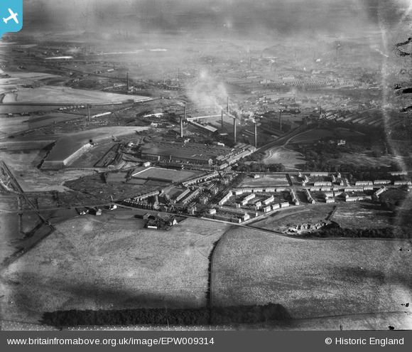
EPW009314 ENGLAND (1923). The Gerard's Bridge Works, St Helens, 1923
© Copyright OpenStreetMap contributors and licensed by the OpenStreetMap Foundation. 2026. Cartography is licensed as CC BY-SA.
Nearby Images (18)
Details
| Title | [EPW009314] The Gerard's Bridge Works, St Helens, 1923 |
| Reference | EPW009314 |
| Date | 1923 |
| Link | |
| Place name | ST HELENS |
| Parish | |
| District | |
| Country | ENGLAND |
| Easting / Northing | 350842, 396828 |
| Longitude / Latitude | -2.7405634300199, 53.46564256181 |
| National Grid Reference | SJ508968 |


![[EPW009314] The Gerard's Bridge Works, St Helens, 1923](http://britainfromabove.org.uk/sites/all/libraries/aerofilms-images/public/100x100/EPW/009/EPW009314.jpg)
![[EAW013755] The Pilkington Brothers Gerard's Bridge Works, St Helens, from the north-west, 1948. This image has been produced from a print.](http://britainfromabove.org.uk/sites/all/libraries/aerofilms-images/public/100x100/EAW/013/EAW013755.jpg)
![[EAW013756] The Pilkington Brothers Gerard's Bridge Works and the surrounding residential area, St Helens, 1948](http://britainfromabove.org.uk/sites/all/libraries/aerofilms-images/public/100x100/EAW/013/EAW013756.jpg)
![[EAW013767] The Pilkington Brothers Gerard's Bridge Works, St Helens, from the north, 1948. This image has been produced from a print.](http://britainfromabove.org.uk/sites/all/libraries/aerofilms-images/public/100x100/EAW/013/EAW013767.jpg)
![[EAW013759] The Pilkington Brothers Gerard's Bridge Works, St Helens, from the north-west, 1948](http://britainfromabove.org.uk/sites/all/libraries/aerofilms-images/public/100x100/EAW/013/EAW013759.jpg)
![[EPW009310] The Gerard's Bridge Works, St Helens, 1923](http://britainfromabove.org.uk/sites/all/libraries/aerofilms-images/public/100x100/EPW/009/EPW009310.jpg)
![[EAW013760] The Pilkington Brothers Gerard's Bridge Works, St Helens, from the north-west, 1948](http://britainfromabove.org.uk/sites/all/libraries/aerofilms-images/public/100x100/EAW/013/EAW013760.jpg)
![[EAW013758] The Pilkington Brothers Gerard's Bridge Works, St Helens, 1948. This image has been produced from a print.](http://britainfromabove.org.uk/sites/all/libraries/aerofilms-images/public/100x100/EAW/013/EAW013758.jpg)
![[EPW009319] The Gerard's Bridge Works and environs, St Helens, 1923](http://britainfromabove.org.uk/sites/all/libraries/aerofilms-images/public/100x100/EPW/009/EPW009319.jpg)
![[EPW061571] The Gerard's Bridge Plate Glass Works and Victoria Park, St Helens, 1939](http://britainfromabove.org.uk/sites/all/libraries/aerofilms-images/public/100x100/EPW/061/EPW061571.jpg)
![[EPW009317] The Gerard's Bridge Works, St Helens, 1923](http://britainfromabove.org.uk/sites/all/libraries/aerofilms-images/public/100x100/EPW/009/EPW009317.jpg)
![[EAW013769] The Pilkington Brothers Gerard's Bridge Works, St Helens, from the north-west, 1948. This image has been produced from a print.](http://britainfromabove.org.uk/sites/all/libraries/aerofilms-images/public/100x100/EAW/013/EAW013769.jpg)
![[EAW013763] The Pilkington Brothers Gerard's Bridge Works, St Helens, 1948](http://britainfromabove.org.uk/sites/all/libraries/aerofilms-images/public/100x100/EAW/013/EAW013763.jpg)
![[EPW009311] The Gerard's Bridge Works, St Helens, 1923](http://britainfromabove.org.uk/sites/all/libraries/aerofilms-images/public/100x100/EPW/009/EPW009311.jpg)
![[EPW009316] The Gerard's Bridge Works, St Helens, 1923](http://britainfromabove.org.uk/sites/all/libraries/aerofilms-images/public/100x100/EPW/009/EPW009316.jpg)
![[EAW013761] The Pilkington Brothers Gerard's Bridge Works, St Helens, from the north-west, 1948](http://britainfromabove.org.uk/sites/all/libraries/aerofilms-images/public/100x100/EAW/013/EAW013761.jpg)
![[EPW061567] The Gerard's Bridge Plate Glass Works, St Helens, 1939](http://britainfromabove.org.uk/sites/all/libraries/aerofilms-images/public/100x100/EPW/061/EPW061567.jpg)
![[EAW013757] The Pilkington Brothers Gerard's Bridge Works, St Helens, 1948](http://britainfromabove.org.uk/sites/all/libraries/aerofilms-images/public/100x100/EAW/013/EAW013757.jpg)

