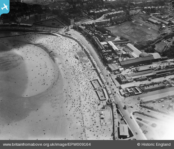
EPW009164 ENGLAND (1923). Marine Terrace, Margate, 1923
© Copyright OpenStreetMap contributors and licensed by the OpenStreetMap Foundation. 2026. Cartography is licensed as CC BY-SA.
Nearby Images (22)
Details
| Title | [EPW009164] Marine Terrace, Margate, 1923 |
| Reference | EPW009164 |
| Date | 1923 |
| Link | |
| Place name | MARGATE |
| Parish | |
| District | |
| Country | ENGLAND |
| Easting / Northing | 634983, 170748 |
| Longitude / Latitude | 1.3776785990214, 51.386546244438 |
| National Grid Reference | TR350707 |
Pins
Be the first to add a comment to this image!


![[EPW009164] Marine Terrace, Margate, 1923](http://britainfromabove.org.uk/sites/all/libraries/aerofilms-images/public/100x100/EPW/009/EPW009164.jpg)
![[EPW009161] The station and Marine Terrace, Margate, 1923](http://britainfromabove.org.uk/sites/all/libraries/aerofilms-images/public/100x100/EPW/009/EPW009161.jpg)
![[EPW009162] Marine Terrace, Margate, 1923](http://britainfromabove.org.uk/sites/all/libraries/aerofilms-images/public/100x100/EPW/009/EPW009162.jpg)
![[EPW035473] The Clock Tower, the Marine Terrace Bathing Pavilion and The Bay, Margate, 1931](http://britainfromabove.org.uk/sites/all/libraries/aerofilms-images/public/100x100/EPW/035/EPW035473.jpg)
![[EPW039327] The beach at Marine Terrace and the Marine Terrace Bathing Pavilion, Margate, 1932](http://britainfromabove.org.uk/sites/all/libraries/aerofilms-images/public/100x100/EPW/039/EPW039327.jpg)
![[EAW024856] Marine Terrace and the beach, Margate, 1949](http://britainfromabove.org.uk/sites/all/libraries/aerofilms-images/public/100x100/EAW/024/EAW024856.jpg)
![[EPW039326] Marine Terrace Bathing Pavilion and environs, Margate, 1932](http://britainfromabove.org.uk/sites/all/libraries/aerofilms-images/public/100x100/EPW/039/EPW039326.jpg)
![[EPW035465] The Marine Terrace Bathing Pavilion, Dreamland Amusement Park and the town, Margate, 1931](http://britainfromabove.org.uk/sites/all/libraries/aerofilms-images/public/100x100/EPW/035/EPW035465.jpg)
![[EPW042850] Marine Terrace Bathing Pavilion, Dreamlands and environs, Margate, from the north-west, 1933](http://britainfromabove.org.uk/sites/all/libraries/aerofilms-images/public/100x100/EPW/042/EPW042850.jpg)
![[EPW009165] Marine Terrace and environs, Margate, 1923](http://britainfromabove.org.uk/sites/all/libraries/aerofilms-images/public/100x100/EPW/009/EPW009165.jpg)
![[EPW018605] The Marine Pavilion and beach, Margate, 1927. This image has been produced from a print.](http://britainfromabove.org.uk/sites/all/libraries/aerofilms-images/public/100x100/EPW/018/EPW018605.jpg)
![[EPW000630] The Clock Tower, Margate, 1920](http://britainfromabove.org.uk/sites/all/libraries/aerofilms-images/public/100x100/EPW/000/EPW000630.jpg)
![[EPW035466] The Marine Terrace Bathing Pavilion, Dreamland Amusement Park and the town, Margate, from the north-west, 1931](http://britainfromabove.org.uk/sites/all/libraries/aerofilms-images/public/100x100/EPW/035/EPW035466.jpg)
![[EAW024852] The Marine Terrace Bathing Pavilion, Dreamland and the town centre, Margate, from the north-west, 1949](http://britainfromabove.org.uk/sites/all/libraries/aerofilms-images/public/100x100/EAW/024/EAW024852.jpg)
![[EPW009238] Marine Terrace and environs, Margate, 1923](http://britainfromabove.org.uk/sites/all/libraries/aerofilms-images/public/100x100/EPW/009/EPW009238.jpg)
![[EAW024855] The town, Margate, from the south-west, 1949](http://britainfromabove.org.uk/sites/all/libraries/aerofilms-images/public/100x100/EAW/024/EAW024855.jpg)
![[EPW042848] Dreamland Amusement Park and environs, Margate, 1933](http://britainfromabove.org.uk/sites/all/libraries/aerofilms-images/public/100x100/EPW/042/EPW042848.jpg)
![[EPW035469] Dreamland Amusement Park and the town, Margate, 1931](http://britainfromabove.org.uk/sites/all/libraries/aerofilms-images/public/100x100/EPW/035/EPW035469.jpg)
![[EAW024853] The Marine Terrace Bathing Pavilion and the town, Margate, from the west, 1949](http://britainfromabove.org.uk/sites/all/libraries/aerofilms-images/public/100x100/EAW/024/EAW024853.jpg)
![[EPW000635] The Clock Tower, Margate, 1920](http://britainfromabove.org.uk/sites/all/libraries/aerofilms-images/public/100x100/EPW/000/EPW000635.jpg)
![[EPW052890] The harbour and the town, Margate, from the west, 1937](http://britainfromabove.org.uk/sites/all/libraries/aerofilms-images/public/100x100/EPW/052/EPW052890.jpg)
![[EPW042847] Dreamland Amusement Park, Margate, 1933](http://britainfromabove.org.uk/sites/all/libraries/aerofilms-images/public/100x100/EPW/042/EPW042847.jpg)