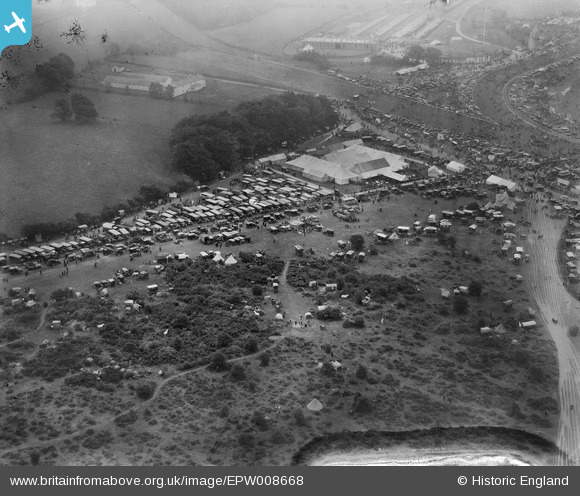
EPW008668 ENGLAND (1923). Tattenham Corner, Epsom, 1923
© Copyright OpenStreetMap contributors and licensed by the OpenStreetMap Foundation. 2026. Cartography is licensed as CC BY-SA.
Nearby Images (14)
Details
| Title | [EPW008668] Tattenham Corner, Epsom, 1923 |
| Reference | EPW008668 |
| Date | 1923 |
| Link | |
| Place name | EPSOM |
| Parish | |
| District | |
| Country | ENGLAND |
| Easting / Northing | 522429, 158505 |
| Longitude / Latitude | -0.24320749703784, 51.311965543447 |
| National Grid Reference | TQ224585 |
Pins
Be the first to add a comment to this image!


![[EPW008668] Tattenham Corner, Epsom, 1923](http://britainfromabove.org.uk/sites/all/libraries/aerofilms-images/public/100x100/EPW/008/EPW008668.jpg)
![[EPW006489] Tattenham Corner on Epsom Racecourse on Derby Day, Epsom Downs, 1921](http://britainfromabove.org.uk/sites/all/libraries/aerofilms-images/public/100x100/EPW/006/EPW006489.jpg)
![[EPW006488] Tattenham Corner on Derby Day, Epsom Downs, 1921](http://britainfromabove.org.uk/sites/all/libraries/aerofilms-images/public/100x100/EPW/006/EPW006488.jpg)
![[EPW007656] Tattenham Corner, Epsom, 1922](http://britainfromabove.org.uk/sites/all/libraries/aerofilms-images/public/100x100/EPW/007/EPW007656.jpg)
![[EPW007908] Tattenham Corner on Epsom Racecourse, Epsom Downs, 1922](http://britainfromabove.org.uk/sites/all/libraries/aerofilms-images/public/100x100/EPW/007/EPW007908.jpg)
![[EPW027520] Epsom Downs, Derby Day, 1929](http://britainfromabove.org.uk/sites/all/libraries/aerofilms-images/public/100x100/EPW/027/EPW027520.jpg)
![[EPW027461] Epsom Downs, Tattenham Corner on Derby Day, 1929](http://britainfromabove.org.uk/sites/all/libraries/aerofilms-images/public/100x100/EPW/027/EPW027461.jpg)
![[EPW035517] Epsom Downs, The Straight and Tattenham Corner on Derby Day, 1931. This image has been produced from a damaged negative.](http://britainfromabove.org.uk/sites/all/libraries/aerofilms-images/public/100x100/EPW/035/EPW035517.jpg)
![[EPW035518] Derby Day, Epsom Downs, from the north-east, 1931. This image has been produced from a damaged negative.](http://britainfromabove.org.uk/sites/all/libraries/aerofilms-images/public/100x100/EPW/035/EPW035518.jpg)
![[EPW006384] Epsom Racecourse, Epsom Downs, from the east, 1921](http://britainfromabove.org.uk/sites/all/libraries/aerofilms-images/public/100x100/EPW/006/EPW006384.jpg)
![[EAW036447] Epsom Downs, the Epsom Derby underway, 1951. This image has been produced from a print.](http://britainfromabove.org.uk/sites/all/libraries/aerofilms-images/public/100x100/EAW/036/EAW036447.jpg)
![[EPW006443] Tattenham Corner Stables at Epsom Racecourse on Derby Day, Epsom Downs, 1921](http://britainfromabove.org.uk/sites/all/libraries/aerofilms-images/public/100x100/EPW/006/EPW006443.jpg)
![[EPW027460] Epsom Downs, Tattenham Corner on Derby Day, 1929](http://britainfromabove.org.uk/sites/all/libraries/aerofilms-images/public/100x100/EPW/027/EPW027460.jpg)
![[EPW006400] Epsom Downs, Derby Day crowds at Epsom Racecourse, 1921. This image has been produced from a print.](http://britainfromabove.org.uk/sites/all/libraries/aerofilms-images/public/100x100/EPW/006/EPW006400.jpg)