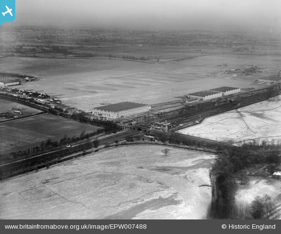
EPW007488 ENGLAND (1922). Castle Bromwich Aerodrome and Station, Castle Bromwich, from the south-west, 1922
© Copyright OpenStreetMap contributors and licensed by the OpenStreetMap Foundation. 2026. Cartography is licensed as CC BY-SA.
Nearby Images (12)
Details
| Title | [EPW007488] Castle Bromwich Aerodrome and Station, Castle Bromwich, from the south-west, 1922 |
| Reference | EPW007488 |
| Date | 10-February-1922 |
| Link | |
| Place name | CASTLE BROMWICH |
| Parish | |
| District | |
| Country | ENGLAND |
| Easting / Northing | 413755, 290251 |
| Longitude / Latitude | -1.7973083480423, 52.509611477091 |
| National Grid Reference | SP138903 |
Pins

gerry-r |
Saturday 3rd of January 2015 08:57:36 PM | |

Templer |
Tuesday 22nd of October 2013 11:54:36 AM | |

frothy |
Sunday 21st of October 2012 08:56:31 AM |


![[EPW007488] Castle Bromwich Aerodrome and Station, Castle Bromwich, from the south-west, 1922](http://britainfromabove.org.uk/sites/all/libraries/aerofilms-images/public/100x100/EPW/007/EPW007488.jpg)
![[EPW020349] British Industries Fair Exhibition Hall, Castle Bromwich, from the south-west, 1928](http://britainfromabove.org.uk/sites/all/libraries/aerofilms-images/public/100x100/EPW/020/EPW020349.jpg)
![[EPW020347] British Industries Fair Exhibition Hall, Castle Bromwich, from the south-west, 1928](http://britainfromabove.org.uk/sites/all/libraries/aerofilms-images/public/100x100/EPW/020/EPW020347.jpg)
![[EPW020345] British Industries Fair Exhibition Hall, Castle Bromwich, from the south-west, 1928](http://britainfromabove.org.uk/sites/all/libraries/aerofilms-images/public/100x100/EPW/020/EPW020345.jpg)
![[EPW020346] British Industries Fair Exhibition Hall, Castle Bromwich, from the south-west, 1928](http://britainfromabove.org.uk/sites/all/libraries/aerofilms-images/public/100x100/EPW/020/EPW020346.jpg)
![[EPW020353] British Industries Fair Exhibition Hall, Castle Bromwich, from the south-west, 1928](http://britainfromabove.org.uk/sites/all/libraries/aerofilms-images/public/100x100/EPW/020/EPW020353.jpg)
![[EPW020350] British Industries Fair Exhibition Hall and Castle Bromwich Railway Station, Castle Bromwich, from the south-west, 1928](http://britainfromabove.org.uk/sites/all/libraries/aerofilms-images/public/100x100/EPW/020/EPW020350.jpg)
![[EPW020351] British Industries Fair Exhibition Hall and Castle Bromwich Railway Station, Castle Bromwich, from the south-west, 1928](http://britainfromabove.org.uk/sites/all/libraries/aerofilms-images/public/100x100/EPW/020/EPW020351.jpg)
![[EPW020348] British Industries Fair Exhibition Hall, Castle Bromwich, from the south-west, 1928](http://britainfromabove.org.uk/sites/all/libraries/aerofilms-images/public/100x100/EPW/020/EPW020348.jpg)
![[EPW020352] British Industries Fair Exhibition Hall, Castle Bromwich, from the south-west, 1928](http://britainfromabove.org.uk/sites/all/libraries/aerofilms-images/public/100x100/EPW/020/EPW020352.jpg)