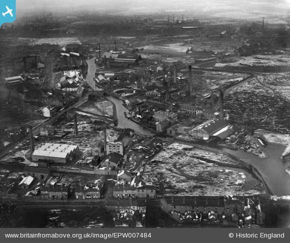
EPW007484 ENGLAND (1922). Chemical Works at Ryders Green and environs, West Bromwich, 1922
© Copyright OpenStreetMap contributors and licensed by the OpenStreetMap Foundation. 2026. Cartography is licensed as CC BY-SA.
Nearby Images (5)
Details
| Title | [EPW007484] Chemical Works at Ryders Green and environs, West Bromwich, 1922 |
| Reference | EPW007484 |
| Date | 10-February-1922 |
| Link | |
| Place name | WEST BROMWICH |
| Parish | |
| District | |
| Country | ENGLAND |
| Easting / Northing | 398617, 291678 |
| Longitude / Latitude | -2.0203856896615, 52.522613380307 |
| National Grid Reference | SO986917 |
Pins

Martin |
Monday 13th of January 2014 04:20:21 PM | |

Martin |
Monday 13th of January 2014 04:19:20 PM | |

Martin |
Monday 13th of January 2014 04:17:45 PM | |

DaveT |
Sunday 8th of December 2013 12:28:34 PM | |

DaveT |
Thursday 5th of December 2013 05:43:50 PM | |

DaveT |
Thursday 5th of December 2013 05:41:11 PM | |

DaveT |
Tuesday 15th of October 2013 11:09:24 AM |


![[EPW007484] Chemical Works at Ryders Green and environs, West Bromwich, 1922](http://britainfromabove.org.uk/sites/all/libraries/aerofilms-images/public/100x100/EPW/007/EPW007484.jpg)
![[EPW007485] Chemical Works at Ryders Green and environs, West Bromwich, 1922](http://britainfromabove.org.uk/sites/all/libraries/aerofilms-images/public/100x100/EPW/007/EPW007485.jpg)
![[EPW007487] Chemical Works at Ryders Green and environs, West Bromwich, 1922](http://britainfromabove.org.uk/sites/all/libraries/aerofilms-images/public/100x100/EPW/007/EPW007487.jpg)
![[EPW007486] Chemical Works at Ryders Green and environs, West Bromwich, 1922](http://britainfromabove.org.uk/sites/all/libraries/aerofilms-images/public/100x100/EPW/007/EPW007486.jpg)
![[EPW007483] Chemical Works at Ryders Green and environs, West Bromwich, 1922](http://britainfromabove.org.uk/sites/all/libraries/aerofilms-images/public/100x100/EPW/007/EPW007483.jpg)