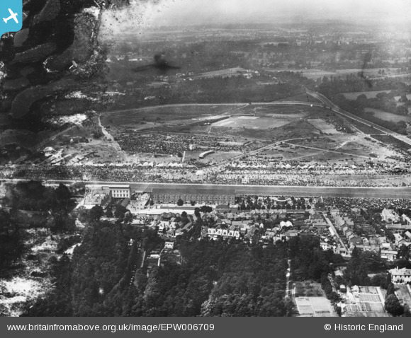
EPW006709 ENGLAND (1921). Ascot, Royal Ascot, from the south, 1921. This image has been produced from a damaged print.
© Copyright OpenStreetMap contributors and licensed by the OpenStreetMap Foundation. 2026. Cartography is licensed as CC BY-SA.
Nearby Images (18)
Details
| Title | [EPW006709] Ascot, Royal Ascot, from the south, 1921. This image has been produced from a damaged print. |
| Reference | EPW006709 |
| Date | June-1921 |
| Link | |
| Place name | ASCOT |
| Parish | SUNNINGHILL AND ASCOT |
| District | |
| Country | ENGLAND |
| Easting / Northing | 492222, 168918 |
| Longitude / Latitude | -0.67381619465811, 51.411280822989 |
| National Grid Reference | SU922689 |
Pins
Be the first to add a comment to this image!


![[EPW006709] Ascot, Royal Ascot, from the south, 1921. This image has been produced from a damaged print.](http://britainfromabove.org.uk/sites/all/libraries/aerofilms-images/public/100x100/EPW/006/EPW006709.jpg)
![[EPW026286] Ascot Racecourse New Stand, Ascot, 1929](http://britainfromabove.org.uk/sites/all/libraries/aerofilms-images/public/100x100/EPW/026/EPW026286.jpg)
![[EAW021006] New Stand at Ascot Race Course and environs, Ascot 1949. This image has been produced from a damaged negative.](http://britainfromabove.org.uk/sites/all/libraries/aerofilms-images/public/100x100/EAW/021/EAW021006.jpg)
![[EAW042135] Ascot Racecourse in the snow, Ascot, 1952](http://britainfromabove.org.uk/sites/all/libraries/aerofilms-images/public/100x100/EAW/042/EAW042135.jpg)
![[EPW006705] Ascot, Royal Ascot, 1921. This image has been produced from a damaged print.](http://britainfromabove.org.uk/sites/all/libraries/aerofilms-images/public/100x100/EPW/006/EPW006705.jpg)
![[EAW042136] Ascot Racecourse in the snow, Ascot, 1952](http://britainfromabove.org.uk/sites/all/libraries/aerofilms-images/public/100x100/EAW/042/EAW042136.jpg)
![[EPW008711] The Grandstand and Royal Enclosure, Ascot, 1923](http://britainfromabove.org.uk/sites/all/libraries/aerofilms-images/public/100x100/EPW/008/EPW008711.jpg)
![[EPW026289] The High Street, Ascot, 1929](http://britainfromabove.org.uk/sites/all/libraries/aerofilms-images/public/100x100/EPW/026/EPW026289.jpg)
![[EPW006703] Ascot, Royal Ascot, 1921](http://britainfromabove.org.uk/sites/all/libraries/aerofilms-images/public/100x100/EPW/006/EPW006703.jpg)
![[EPW008708] The Racecourse, Ascot, 1923](http://britainfromabove.org.uk/sites/all/libraries/aerofilms-images/public/100x100/EPW/008/EPW008708.jpg)
![[EPW008707] The Grandstand and Royal Enclosure, Ascot, 1923](http://britainfromabove.org.uk/sites/all/libraries/aerofilms-images/public/100x100/EPW/008/EPW008707.jpg)
![[EPW008704] Ascot, possibly the Ascot Gold Cup, 1923](http://britainfromabove.org.uk/sites/all/libraries/aerofilms-images/public/100x100/EPW/008/EPW008704.jpg)
![[EPW008717] The Racecourse, Ascot, 1923](http://britainfromabove.org.uk/sites/all/libraries/aerofilms-images/public/100x100/EPW/008/EPW008717.jpg)
![[EPW026290] Ascot Racecourse Royal Enclosure and grandstands, Ascot, 1929](http://britainfromabove.org.uk/sites/all/libraries/aerofilms-images/public/100x100/EPW/026/EPW026290.jpg)
![[EPW008709] The Racecourse, Ascot, 1923](http://britainfromabove.org.uk/sites/all/libraries/aerofilms-images/public/100x100/EPW/008/EPW008709.jpg)
![[EPW026287] Ascot Racecourse, Ascot, from the south, 1929](http://britainfromabove.org.uk/sites/all/libraries/aerofilms-images/public/100x100/EPW/026/EPW026287.jpg)
![[EPW008706] The Racecourse, Ascot, 1923](http://britainfromabove.org.uk/sites/all/libraries/aerofilms-images/public/100x100/EPW/008/EPW008706.jpg)
![[EPW006707] Ascot, Royal Ascot, 1921. This image has been produced from a damaged print.](http://britainfromabove.org.uk/sites/all/libraries/aerofilms-images/public/100x100/EPW/006/EPW006707.jpg)