
EPW006170 ENGLAND (1921). Aeroville, Hendon, 1921

© Copyright OpenStreetMap contributors and licensed by the OpenStreetMap Foundation. 2026. Cartography is licensed as CC BY-SA.
Nearby Images (19)
EPW006170

EPW011926

EPW001728

EPW008758

EPW009090

EPW010855

EPW026592

EPW006171

EPW018788

EPW018789

EPW018790

EPW018791

EPW018792

EPW018793

EPW018794

EPW018795

EPW018796

EPW018797

EPW018798

Details
| Title | [EPW006170] Aeroville, Hendon, 1921 |
| Reference | EPW006170 |
| Date | April-1921 |
| Link | |
| Place name | HENDON |
| Parish | |
| District | |
| Country | ENGLAND |
| Easting / Northing | 521252, 190160 |
| Longitude / Latitude | -0.24923485045338, 51.596745444568 |
| National Grid Reference | TQ213902 |
Pins

Class31 |
Monday 10th of March 2014 07:41:25 PM | |
|
Class31 |
Monday 10th of March 2014 07:39:43 PM | |
|
Class31 |
Monday 10th of March 2014 07:36:32 PM |
User Comment Contributions
View is looking south. |
Class31 |
Monday 10th of March 2014 07:37:06 PM |
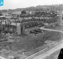
"Aeroville" was built by Claude Grahame-White alongside The London Aerodrome originally as housing for local aviation industry workers. |
Katy Whitaker |
Monday 18th of June 2012 12:50:32 PM |