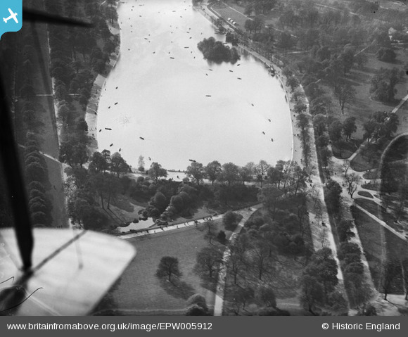
EPW005912 ENGLAND (1921). The Serpentine, Westminster, 1921
    © Copyright OpenStreetMap contributors and licensed by the OpenStreetMap Foundation. 2025. Cartography is licensed as CC BY-SA.
  
Nearby Images (6)
Details
| Title | [EPW005912] The Serpentine, Westminster, 1921 | 
| Reference | EPW005912 | 
| Date | March-1921 | 
| Link | |
| Place name | WESTMINSTER | 
| Parish | |
| District | |
| Country | ENGLAND | 
| Easting / Northing | 527780, 180006 | 
| Longitude / Latitude | -0.15871696976204, 51.504040343676 | 
| National Grid Reference | TQ278800 | 
Pins
|   Alan McFaden | Sunday 7th of July 2013 10:24:03 AM | 
 
             
  ![[EPW005912] The Serpentine, Westminster, 1921](http://britainfromabove.org.uk/sites/all/libraries/aerofilms-images/public/100x100/EPW/005/EPW005912.jpg) 
  
                                          ![[EAW004917] St James and the view over the Thames, Westminster, from the west, 1947](http://britainfromabove.org.uk/sites/all/libraries/aerofilms-images/public/100x100/EAW/004/EAW004917.jpg) 
 ![[EAW000557] The Serpentine, Hyde Park, 1946](http://britainfromabove.org.uk/sites/all/libraries/aerofilms-images/public/100x100/EAW/000/EAW000557.jpg) 
 ![[EAW021081] Park Lane and the cityscape towards Regent's Park, Hyde Park, from the south, 1949. This image was marked by Aerofilms Ltd for photo editing.](http://britainfromabove.org.uk/sites/all/libraries/aerofilms-images/public/100x100/EAW/021/EAW021081.jpg) 
 ![[EPW016661] The Knightsbridge road, Knightsbridge, 1926](http://britainfromabove.org.uk/sites/all/libraries/aerofilms-images/public/100x100/EPW/016/EPW016661.jpg) 
 ![[EPW016660] The Knightsbridge road and Wilton Place, Knightsbridge, 1926](http://britainfromabove.org.uk/sites/all/libraries/aerofilms-images/public/100x100/EPW/016/EPW016660.jpg) 
 
 Serpentine Hyde Park
 Serpentine Hyde Park