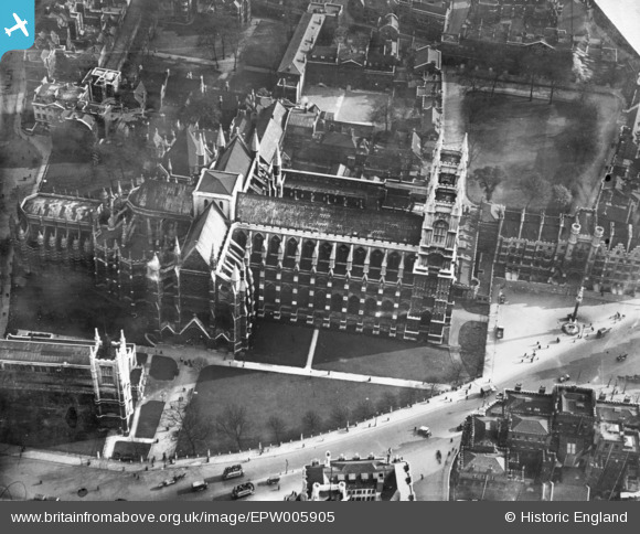
EPW005905 ENGLAND (1921). Westminster Abbey, Westminster, 1921. This image has been produced from a print.
© Copyright OpenStreetMap contributors and licensed by the OpenStreetMap Foundation. 2026. Cartography is licensed as CC BY-SA.
Nearby Images (48)
Details
| Title | [EPW005905] Westminster Abbey, Westminster, 1921. This image has been produced from a print. |
| Reference | EPW005905 |
| Date | March-1921 |
| Link | |
| Place name | WESTMINSTER |
| Parish | |
| District | |
| Country | ENGLAND |
| Easting / Northing | 530045, 179501 |
| Longitude / Latitude | -0.12628360857907, 51.498984824303 |
| National Grid Reference | TQ300795 |
Pins

Alan McFaden |
Thursday 6th of November 2014 05:12:24 PM | |

Alan McFaden |
Thursday 6th of November 2014 05:11:45 PM |
User Comment Contributions

Westminster Abbey |

Alan McFaden |
Thursday 6th of November 2014 05:09:59 PM |


![[EPW005905] Westminster Abbey, Westminster, 1921. This image has been produced from a print.](http://britainfromabove.org.uk/sites/all/libraries/aerofilms-images/public/100x100/EPW/005/EPW005905.jpg)
![[EPW006162] Westminster Abbey and environs, Westminster, 1921](http://britainfromabove.org.uk/sites/all/libraries/aerofilms-images/public/100x100/EPW/006/EPW006162.jpg)
![[EAW048435] Clock Tower (Big Ben) and temporary stands being erected outside Westminster Abbey for the Coronation of Queen Elizabeth II, Westminster, 1953](http://britainfromabove.org.uk/sites/all/libraries/aerofilms-images/public/100x100/EAW/048/EAW048435.jpg)
![[EAW048437] Temporary stands being erected outside Westminster Abbey for the Coronation of Queen Elizabeth II, Westminster, 1953](http://britainfromabove.org.uk/sites/all/libraries/aerofilms-images/public/100x100/EAW/048/EAW048437.jpg)
![[EAW048060] Westminster Abbey, Parliament Square and Clock Tower (Big Ben), Westminster, 1952](http://britainfromabove.org.uk/sites/all/libraries/aerofilms-images/public/100x100/EAW/048/EAW048060.jpg)
![[EAW048422] The erection of stands in preparation for the coronation of Queen Elizabeth II by Westminster Abbey, Westminster, 1953](http://britainfromabove.org.uk/sites/all/libraries/aerofilms-images/public/100x100/EAW/048/EAW048422.jpg)
![[EAW048061] Westminster Abbey, Parliament Square and Clock Tower (Big Ben), Westminster, 1952](http://britainfromabove.org.uk/sites/all/libraries/aerofilms-images/public/100x100/EAW/048/EAW048061.jpg)
![[EAW048421] The erection of stands in preparation for the coronation of Queen Elizabeth II by Westminster Abbey, Westminster, 1953](http://britainfromabove.org.uk/sites/all/libraries/aerofilms-images/public/100x100/EAW/048/EAW048421.jpg)
![[EAW048438] Temporary stands being erected outside Westminster Abbey for the Coronation of Queen Elizabeth II, Westminster, 1953](http://britainfromabove.org.uk/sites/all/libraries/aerofilms-images/public/100x100/EAW/048/EAW048438.jpg)
![[EAW049772] Temporary stands erected outside Westminster Abbey for the Coronation of Queen Elizabeth II, Westminster, 1953](http://britainfromabove.org.uk/sites/all/libraries/aerofilms-images/public/100x100/EAW/049/EAW049772.jpg)
![[EPW019024] Westminster Abbey, The Houses of Parliament and environs, Westminster, 1927](http://britainfromabove.org.uk/sites/all/libraries/aerofilms-images/public/100x100/EPW/019/EPW019024.jpg)
![[EAW000524] The Houses of Parliament and Westminster Abbey, Westminster, 1946](http://britainfromabove.org.uk/sites/all/libraries/aerofilms-images/public/100x100/EAW/000/EAW000524.jpg)
![[EPW024749] Westminster Abbey and environs, Westminster, 1928](http://britainfromabove.org.uk/sites/all/libraries/aerofilms-images/public/100x100/EPW/024/EPW024749.jpg)
![[EAW000527] The Houses of Parliament, Westminster Abbey, nearby Government Offices and environs, Westminster, 1946](http://britainfromabove.org.uk/sites/all/libraries/aerofilms-images/public/100x100/EAW/000/EAW000527.jpg)
![[EAW049779] Temporary stands erected at Westminster Abbey and Parliament Square for the Coronation of Queen Elizabeth II, Westminster, 1953](http://britainfromabove.org.uk/sites/all/libraries/aerofilms-images/public/100x100/EAW/049/EAW049779.jpg)
![[EAW048062] Westminster Abbey and the surrounding area, Westminster, 1952](http://britainfromabove.org.uk/sites/all/libraries/aerofilms-images/public/100x100/EAW/048/EAW048062.jpg)
![[EAW048436] Temporary stands being erected outside Westminster Abbey for the Coronation of Queen Elizabeth II, Westminster, 1953](http://britainfromabove.org.uk/sites/all/libraries/aerofilms-images/public/100x100/EAW/048/EAW048436.jpg)
![[EAW049015] Stands erected by Parliament Square and Westminster Abbey in preparation for the coronation of Queen Elizabeth II, Westminster, 1953](http://britainfromabove.org.uk/sites/all/libraries/aerofilms-images/public/100x100/EAW/049/EAW049015.jpg)
![[EPR000412] Victoria Street, the Houses of Parliament and environs, Westminster, 1934. This image was marked by Aero Pictorial for photo editing.](http://britainfromabove.org.uk/sites/all/libraries/aerofilms-images/public/100x100/EPR/000/EPR000412.jpg)
![[EAW049016] Stands erected by Parliament Square and Westminster Abbey in preparation for the coronation of Queen Elizabeth II, Westminster, 1953](http://britainfromabove.org.uk/sites/all/libraries/aerofilms-images/public/100x100/EAW/049/EAW049016.jpg)
![[EPR000211] The River Thames and surrounding city from the Houses of Parliament towards Blackfriars Bridge, Westminster, from the south-west, 1934](http://britainfromabove.org.uk/sites/all/libraries/aerofilms-images/public/100x100/EPR/000/EPR000211.jpg)
![[EAW048063] Westminster Abbey and the surrounding area, Westminster, 1952](http://britainfromabove.org.uk/sites/all/libraries/aerofilms-images/public/100x100/EAW/048/EAW048063.jpg)
![[EPW017272] The River Thames and the city, Westminster, from the south-west, 1926](http://britainfromabove.org.uk/sites/all/libraries/aerofilms-images/public/100x100/EPW/017/EPW017272.jpg)
![[EAW049403] The Houses of Parliament, St James's Park and environs, Westminster, 1953](http://britainfromabove.org.uk/sites/all/libraries/aerofilms-images/public/100x100/EAW/049/EAW049403.jpg)
![[EPW019022] The Houses of Parliament, Westminster Abbey and environs, Westminster, 1927](http://britainfromabove.org.uk/sites/all/libraries/aerofilms-images/public/100x100/EPW/019/EPW019022.jpg)
![[EAW043635] The Houses of Parliament, Westminster Bridge, Waterloo Station and environs, Westminster, from the west, 1952](http://britainfromabove.org.uk/sites/all/libraries/aerofilms-images/public/100x100/EAW/043/EAW043635.jpg)
![[EAW049766] St Margaret's Church and temporary stands erected around Parliament Square for the Coronation of Queen Elizabeth II, Westminster, 1953](http://britainfromabove.org.uk/sites/all/libraries/aerofilms-images/public/100x100/EAW/049/EAW049766.jpg)
![[EAW049770] Clock Tower (Big Ben) and temporary stands erected around Parliament Square and Westminster Abbey for the Coronation of Queen Elizabeth II, Westminster, 1953](http://britainfromabove.org.uk/sites/all/libraries/aerofilms-images/public/100x100/EAW/049/EAW049770.jpg)
![[EAW049400] The Houses of Parliament, Parliament Square and environs, Westminster, 1953](http://britainfromabove.org.uk/sites/all/libraries/aerofilms-images/public/100x100/EAW/049/EAW049400.jpg)
![[EPW028627] The Houses of Parliament, St James's Park and environs, St James, 1929](http://britainfromabove.org.uk/sites/all/libraries/aerofilms-images/public/100x100/EPW/028/EPW028627.jpg)
![[EPW006316] The Houses of Parliament and Westminster Abbey, Westminster, 1921](http://britainfromabove.org.uk/sites/all/libraries/aerofilms-images/public/100x100/EPW/006/EPW006316.jpg)
![[EPW021770] Westminster Abbey and the Houses of Parliament, Westminster, from the west, 1928](http://britainfromabove.org.uk/sites/all/libraries/aerofilms-images/public/100x100/EPW/021/EPW021770.jpg)
![[EAW033443] The Houses of Parliament and River Thames, Westminster, from the south-west, 1950](http://britainfromabove.org.uk/sites/all/libraries/aerofilms-images/public/100x100/EAW/033/EAW033443.jpg)
![[EAW000525] The Houses of Parliament, Westminster Abbey and surrounding Government Offices, Westminster, 1946](http://britainfromabove.org.uk/sites/all/libraries/aerofilms-images/public/100x100/EAW/000/EAW000525.jpg)
![[EPW056680] Parliament Square and environs, Westminster, 1938](http://britainfromabove.org.uk/sites/all/libraries/aerofilms-images/public/100x100/EPW/056/EPW056680.jpg)
![[EAW048870] The Houses of Parliament and temporary stands erected outside Westminster Abbey for the Coronation of Queen Elizabeth II, Westminster, 1953](http://britainfromabove.org.uk/sites/all/libraries/aerofilms-images/public/100x100/EAW/048/EAW048870.jpg)
![[EPW006301] The Houses of Parliament, Westminster Abbey and Whitehall, Westminster, 1921](http://britainfromabove.org.uk/sites/all/libraries/aerofilms-images/public/100x100/EPW/006/EPW006301.jpg)
![[EAW043637] The Houses of Parliament, Westminster Bridge and Waterloo Station, Westminster, from the west, 1952](http://britainfromabove.org.uk/sites/all/libraries/aerofilms-images/public/100x100/EAW/043/EAW043637.jpg)
![[EAW021089] The Houses of Parliament and Westminster Abbey, Westminster, 1949. This image has been produced from a damaged negative.](http://britainfromabove.org.uk/sites/all/libraries/aerofilms-images/public/100x100/EAW/021/EAW021089.jpg)
![[EPW021769] Westminster Abbey and the Houses of Parliament, Westminster, from the west, 1928](http://britainfromabove.org.uk/sites/all/libraries/aerofilms-images/public/100x100/EPW/021/EPW021769.jpg)
![[EAW043636] Westminster Abbey, the Houses of Parliament and the River Thames, Westminster, from the south-west, 1952](http://britainfromabove.org.uk/sites/all/libraries/aerofilms-images/public/100x100/EAW/043/EAW043636.jpg)
![[EAW043636A] Westminster Abbey, the Houses of Parliament and the River Thames, Westminster, from the south-west, 1952](http://britainfromabove.org.uk/sites/all/libraries/aerofilms-images/public/100x100/EAW/043/EAW043636A.jpg)
![[EAW049017] Government Offices Great George Street and stands erected by Parliament Square and Westminster Abbey in preparation for the coronation of Queen Elizabeth II, Westminster, 1953](http://britainfromabove.org.uk/sites/all/libraries/aerofilms-images/public/100x100/EAW/049/EAW049017.jpg)
![[EAW000523] The Houses of Parliament, Westminster Abbey and surrounding Government Offices, Westminster, 1946](http://britainfromabove.org.uk/sites/all/libraries/aerofilms-images/public/100x100/EAW/000/EAW000523.jpg)
![[EAW043610] Parliament Square and environs, Westminster, 1952](http://britainfromabove.org.uk/sites/all/libraries/aerofilms-images/public/100x100/EAW/043/EAW043610.jpg)
![[EAW049758] Parliament Street and temporary stands erected at Parliament Square for the Coronation of Queen Elizabeth II, Westminster, 1953](http://britainfromabove.org.uk/sites/all/libraries/aerofilms-images/public/100x100/EAW/049/EAW049758.jpg)
![[EAW000476] The Houses of Parliament, Victoria Tower Garden and environs, Westminster, 1946. This image has been produced from a damaged negative.](http://britainfromabove.org.uk/sites/all/libraries/aerofilms-images/public/100x100/EAW/000/EAW000476.jpg)
![[EAW005242] The Foreign and Commonwealth Office, HM Treasury, The Palace of Westminster and environs, Westminster, from the north-west, 1947](http://britainfromabove.org.uk/sites/all/libraries/aerofilms-images/public/100x100/EAW/005/EAW005242.jpg)

