
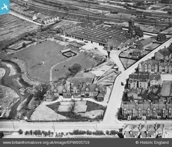
EPW005719 ENGLAND (1921). The Schweppes Mineral Water Factory, West Hendon, 1921. This image has been produced from a copy-negative.
© Copyright OpenStreetMap contributors and licensed by the OpenStreetMap Foundation. 2026. Cartography is licensed as CC BY-SA.
Nearby Images (11)
EPW005719

EPW006281

EAW043285

EAW043284

EAW043289

EPW025737

EAW043286

EAW043287

EAW043288

EAW043282

EAW043283

Details
| Title | [EPW005719] The Schweppes Mineral Water Factory, West Hendon, 1921. This image has been produced from a copy-negative. |
| Reference | EPW005719 |
| Date | March-1921 |
| Link | |
| Place name | WEST HENDON |
| Parish | |
| District | |
| Country | ENGLAND |
| Easting / Northing | 521892, 188383 |
| Longitude / Latitude | -0.24061577759112, 51.580635391309 |
| National Grid Reference | TQ219884 |
Pins

John W |
Tuesday 21st of March 2023 03:51:25 PM | |
|
colsouth111 |
Friday 26th of September 2014 07:17:35 PM | |
|
colsouth111 |
Monday 15th of September 2014 07:09:39 PM | |
|
colsouth111 |
Monday 15th of September 2014 07:06:13 PM | |
|
colsouth111 |
Monday 15th of September 2014 07:04:15 PM | |
|
colsouth111 |
Monday 15th of September 2014 07:01:36 PM |
User Comment Contributions
I was born behind the Schweppes factory in Deerfield Cottages.My father worked for Schweppes for over 25 years,sad times when it was closing down and we left in about 1970. |
Derek The Dane |
Monday 19th of January 2015 04:29:49 PM |

A cracking shot of the famous factory opened in 1895. It finally closed in 1980. Just one of a number of recently released early images and one that ties in nicely with the Hyde/West Hendon picture previously added by Katy. |
colsouth111 |
Tuesday 16th of September 2014 10:58:22 AM |
An excellent source of earlier info on these areas is the map site http://maps.nls.uk/geo/explore which gives you an 1880/1913 map laid over a modern aerial view. It covers England and Wales and you can zoom in to the area you want. |
colsouth111 |
Tuesday 16th of September 2014 10:58:22 AM |