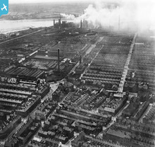
EPW004060 ENGLAND (1920). General view over the town, Barrow-in-Furness, from the south-east, 1920
© Copyright OpenStreetMap contributors and licensed by the OpenStreetMap Foundation. 2026. Cartography is licensed as CC BY-SA.
Details
| Title | [EPW004060] General view over the town, Barrow-in-Furness, from the south-east, 1920 |
| Reference | EPW004060 |
| Date | July-1920 |
| Link | |
| Place name | BARROW-IN-FURNESS |
| Parish | |
| District | |
| Country | ENGLAND |
| Easting / Northing | 319739, 469371 |
| Longitude / Latitude | -3.2279305223878, 54.113764124756 |
| National Grid Reference | SD197694 |
Pins

Westy57 |
Saturday 9th of May 2020 10:37:59 AM | |

steve |
Saturday 10th of November 2012 09:12:44 PM | |

steve |
Saturday 10th of November 2012 09:05:10 PM | |

Neil Loughran |
Monday 17th of September 2012 09:34:33 PM | |

Philip Murray |
Tuesday 28th of August 2012 10:23:01 PM | |
Actually, the rugby ground stands on the site of those reservoirs. The 'old church' is simply some rather fancy windows on the particularly derelict half of the old juteworks. This half of the works became the Corporation bus depot for many years, before redevelopment into shops. |

aiwacat |
Monday 17th of September 2012 11:00:23 PM |

aiwacat |
Sunday 15th of July 2012 12:43:16 AM | |

aiwacat |
Sunday 15th of July 2012 12:42:06 AM | |

steve |
Saturday 14th of July 2012 10:59:21 PM | |

willi |
Saturday 7th of July 2012 11:15:02 PM | |

willi |
Saturday 7th of July 2012 11:13:03 PM | |

willi |
Saturday 7th of July 2012 11:08:14 PM | |

willi |
Saturday 7th of July 2012 11:07:07 PM | |

willi |
Saturday 7th of July 2012 11:04:01 PM |
User Comment Contributions

oversands |
Tuesday 11th of December 2012 05:59:14 PM | |

Philip Murray |
Tuesday 28th of August 2012 10:27:40 PM |


![[EPW004060] General view over the town, Barrow-in-Furness, from the south-east, 1920](http://britainfromabove.org.uk/sites/all/libraries/aerofilms-images/public/100x100/EPW/004/EPW004060.jpg)
![[EPW004061] Ramsden Square, Barrow-in-Furness, 1920](http://britainfromabove.org.uk/sites/all/libraries/aerofilms-images/public/100x100/EPW/004/EPW004061.jpg)
