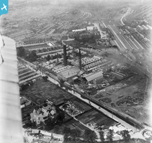
EPW003094 ENGLAND (1920). The Lead Works and the Chester Canal, Chester, 1920
© Copyright OpenStreetMap contributors and licensed by the OpenStreetMap Foundation. 2026. Cartography is licensed as CC BY-SA.
Details
| Title | [EPW003094] The Lead Works and the Chester Canal, Chester, 1920 |
| Reference | EPW003094 |
| Date | July-1920 |
| Link | |
| Place name | CHESTER |
| Parish | |
| District | |
| Country | ENGLAND |
| Easting / Northing | 341442, 366691 |
| Longitude / Latitude | -2.8765862074231, 53.193789879781 |
| National Grid Reference | SJ414667 |
Pins

Karlos |
Saturday 7th of May 2022 03:06:24 AM | |

incony |
Thursday 18th of October 2018 08:29:23 AM | |

raucousangel |
Thursday 10th of March 2016 10:30:40 PM | |

Bunn72 |
Monday 30th of November 2015 01:57:45 PM | |

Bunn72 |
Monday 30th of November 2015 01:55:35 PM | |

Bunn72 |
Monday 30th of November 2015 01:54:05 PM | |

Bunn72 |
Monday 30th of November 2015 01:53:28 PM | |

Bunn72 |
Monday 30th of November 2015 01:52:14 PM | |

Bunn72 |
Monday 30th of November 2015 01:51:02 PM | |

Ange |
Saturday 24th of August 2013 11:15:11 PM | |

Pete65 |
Sunday 5th of May 2013 05:33:00 PM | |

MarilynBagger |
Wednesday 18th of July 2012 09:40:11 AM |


![[EPW003094] The Lead Works and the Chester Canal, Chester, 1920](http://britainfromabove.org.uk/sites/all/libraries/aerofilms-images/public/100x100/EPW/003/EPW003094.jpg)
![[EPW040166] Boughton, Foregate Street and environs, Chester, 1932](http://britainfromabove.org.uk/sites/all/libraries/aerofilms-images/public/100x100/EPW/040/EPW040166.jpg)
![[EPW036915] The Chester Lead Works and environs, Boughton, 1931](http://britainfromabove.org.uk/sites/all/libraries/aerofilms-images/public/100x100/EPW/036/EPW036915.jpg)

