
EPW002072 ENGLAND (1920). Blackpool Tower and the Promenade, Blackpool, 1920

© Copyright OpenStreetMap contributors and licensed by the OpenStreetMap Foundation. 2026. Cartography is licensed as CC BY-SA.
Nearby Images (17)
EPW002072

EPW002077

EAW026234

EPW002066

EPW002061

EPW038913

EPW002062

EAW026228

EPW002063

EPW029210

EPW012489

EPW002057

EAW026233

EPW002073

EAW023418

EAW026236

EPW002065

Details
| Title | [EPW002072] Blackpool Tower and the Promenade, Blackpool, 1920 |
| Reference | EPW002072 |
| Date | July-1920 |
| Link | |
| Place name | BLACKPOOL |
| Parish | |
| District | |
| Country | ENGLAND |
| Easting / Northing | 330580, 436361 |
| Longitude / Latitude | -3.0545888538485, 53.818673473755 |
| National Grid Reference | SD306364 |
Pins

bradfordsteve |
Sunday 16th of June 2013 04:46:06 PM | |
|
bradfordsteve |
Sunday 16th of June 2013 04:45:27 PM |
User Comment Contributions
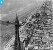
Blackpool Tower, the North Pier and the Metropole Hotel. The Metropole doesn't look that different today. On the right of the photo in the middle is the Sacred Heart Catholic Church that also hasn't changed and the building that was formerly Yate's Wine Lodge, which sadly burnt down a few years ago. |
former user |
Friday 29th of June 2012 09:10:22 AM |