
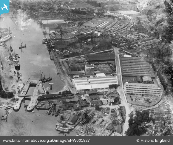
EPW001827 ENGLAND (1920). Ipswich Lock and Eagle Mill, Ipswich, 1920
© Copyright OpenStreetMap contributors and licensed by the OpenStreetMap Foundation. 2026. Cartography is licensed as CC BY-SA.
Nearby Images (12)
EPW001827

EPW058745

EPW041400

EPW032849

EPW032835

EPW032855

EPW001825

EPW032863

EPW032858

EPW032877

EPW032836

EPW032859

Details
| Title | [EPW001827] Ipswich Lock and Eagle Mill, Ipswich, 1920 |
| Reference | EPW001827 |
| Date | June-1920 |
| Link | |
| Place name | IPSWICH |
| Parish | |
| District | |
| Country | ENGLAND |
| Easting / Northing | 617075, 243465 |
| Longitude / Latitude | 1.1660107594074, 52.046577561007 |
| National Grid Reference | TM171435 |
Pins

pf329 |
Sunday 16th of June 2019 11:06:07 AM | |
|
MB |
Tuesday 4th of October 2016 09:20:00 PM | |
|
MB |
Tuesday 4th of October 2016 09:19:22 PM | |
|
Where's Canning Town? |
Saturday 15th of March 2014 03:17:06 PM |
User Comment Contributions
A boat-builders yard in the foreground, which has its own rail siding |
MB |
Tuesday 4th of October 2016 09:18:37 PM |
R & W Paul were producers of animal feeds. The firm merged with BOCM (British Oil and Cake Mills Ltd) in 1992 to form BOCM Pauls: https://en.wikipedia.org/wiki/BOCM_Pauls |
MB |
Tuesday 4th of October 2016 09:16:50 PM |

Ransomes Sims & Jefferies produced the FE.2b biplane in W.W.1 A picture taken inside shows my granddad, second from right in the middle row. http://www.flickr.com/photos/kindredspirituk/10609728686/in/photostream/ |
Where's Canning Town? |
Saturday 15th of March 2014 03:21:21 PM |