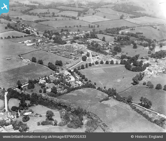
EPW001633 ENGLAND (1920). View of Godstone from Godstone Green, Godstone, 1920
© Copyright OpenStreetMap contributors and licensed by the OpenStreetMap Foundation. 2026. Cartography is licensed as CC BY-SA.
Details
| Title | [EPW001633] View of Godstone from Godstone Green, Godstone, 1920 |
| Reference | EPW001633 |
| Date | June-1920 |
| Link | |
| Place name | GODSTONE |
| Parish | GODSTONE |
| District | |
| Country | ENGLAND |
| Easting / Northing | 534880, 151643 |
| Longitude / Latitude | -0.06723721260668, 51.247476352174 |
| National Grid Reference | TQ349516 |
Pins

David960 |
Saturday 20th of May 2017 11:45:28 AM | |

David960 |
Saturday 20th of May 2017 11:42:56 AM | |

David960 |
Saturday 20th of May 2017 11:42:52 AM | |

Terry the Carpet Estimator |
Wednesday 1st of June 2016 07:50:55 PM | |

Terry the Carpet Estimator |
Wednesday 1st of June 2016 07:47:49 PM | |

Terry the Carpet Estimator |
Wednesday 1st of June 2016 07:46:24 PM | |

Terry the Carpet Estimator |
Wednesday 1st of June 2016 07:45:15 PM | |

Terry the Carpet Estimator |
Wednesday 1st of June 2016 07:38:52 PM | |

Terry the Carpet Estimator |
Wednesday 1st of June 2016 07:37:22 PM | |

Terry the Carpet Estimator |
Wednesday 1st of June 2016 07:35:40 PM |


![[EPW001633] View of Godstone from Godstone Green, Godstone, 1920](http://britainfromabove.org.uk/sites/all/libraries/aerofilms-images/public/100x100/EPW/001/EPW001633.jpg)
![[EPW001632] View of Godstone along Godstone Green Road, Godstone, 1920](http://britainfromabove.org.uk/sites/all/libraries/aerofilms-images/public/100x100/EPW/001/EPW001632.jpg)