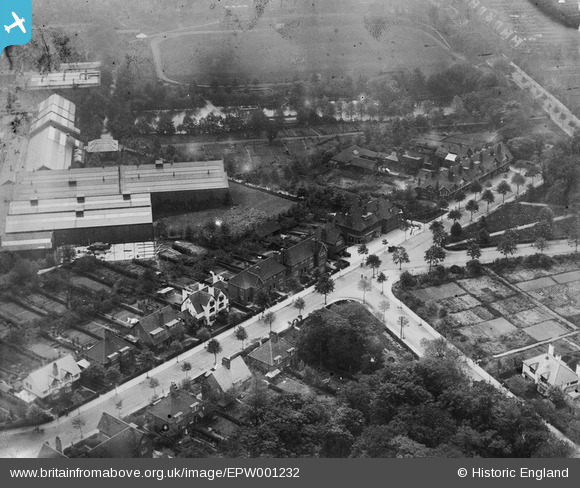
EPW001232 ENGLAND (1920). Bournville Works and Recreation Ground, Bournville, 1920
© Copyright OpenStreetMap contributors and licensed by the OpenStreetMap Foundation. 2026. Cartography is licensed as CC BY-SA.
Nearby Images (16)
Details
| Title | [EPW001232] Bournville Works and Recreation Ground, Bournville, 1920 |
| Reference | EPW001232 |
| Date | May-1920 |
| Link | |
| Place name | BOURNVILLE |
| Parish | |
| District | |
| Country | ENGLAND |
| Easting / Northing | 404580, 281343 |
| Longitude / Latitude | -1.9326319902761, 52.429673822923 |
| National Grid Reference | SP046813 |
Pins

John Smith |
Sunday 17th of March 2013 12:14:26 AM | |

John Smith |
Sunday 17th of March 2013 12:12:53 AM | |

John Smith |
Sunday 17th of March 2013 12:12:22 AM | |

John Smith |
Sunday 17th of March 2013 12:11:54 AM | |

John Smith |
Sunday 17th of March 2013 12:11:03 AM | |

John Smith |
Sunday 17th of March 2013 12:09:46 AM | |

John Smith |
Sunday 17th of March 2013 12:09:03 AM |


![[EPW001232] Bournville Works and Recreation Ground, Bournville, 1920](http://britainfromabove.org.uk/sites/all/libraries/aerofilms-images/public/100x100/EPW/001/EPW001232.jpg)
![[EPW024806] The Bournville Cocoa and Chocolate Works and environs, Bournville, 1928](http://britainfromabove.org.uk/sites/all/libraries/aerofilms-images/public/100x100/EPW/024/EPW024806.jpg)
![[EPW024802] The Bournville Cocoa and Chocolate Works and environs, Bournville, 1928](http://britainfromabove.org.uk/sites/all/libraries/aerofilms-images/public/100x100/EPW/024/EPW024802.jpg)
![[EPW024811] The Bournville Cocoa and Chocolate Works and environs, Bournville, 1928. This image has been produced from a print.](http://britainfromabove.org.uk/sites/all/libraries/aerofilms-images/public/100x100/EPW/024/EPW024811.jpg)
![[EPW024797] The Bournville Cocoa and Chocolate Works, Bournville, 1928](http://britainfromabove.org.uk/sites/all/libraries/aerofilms-images/public/100x100/EPW/024/EPW024797.jpg)
![[EPW024800] The Bournville Cocoa and Chocolate Works and environs, Bournville, 1928](http://britainfromabove.org.uk/sites/all/libraries/aerofilms-images/public/100x100/EPW/024/EPW024800.jpg)
![[EPW024810] The Bournville Cocoa and Chocolate Works and environs, Bournville, 1928](http://britainfromabove.org.uk/sites/all/libraries/aerofilms-images/public/100x100/EPW/024/EPW024810.jpg)
![[EPW024799] The Bournville Cocoa and Chocolate Works and environs, Bournville, 1928](http://britainfromabove.org.uk/sites/all/libraries/aerofilms-images/public/100x100/EPW/024/EPW024799.jpg)
![[EPW024801] The Bournville Cocoa and Chocolate Works and environs, Bournville, 1928](http://britainfromabove.org.uk/sites/all/libraries/aerofilms-images/public/100x100/EPW/024/EPW024801.jpg)
![[EPW024798] The Bournville Cocoa and Chocolate Works and environs, Bournville, 1928](http://britainfromabove.org.uk/sites/all/libraries/aerofilms-images/public/100x100/EPW/024/EPW024798.jpg)
![[EPW024805] The Bournville Cocoa and Chocolate Works and environs, Bournville, 1928](http://britainfromabove.org.uk/sites/all/libraries/aerofilms-images/public/100x100/EPW/024/EPW024805.jpg)
![[EPW001237] Bournville Works and Recreation Ground, Bournville, 1920](http://britainfromabove.org.uk/sites/all/libraries/aerofilms-images/public/100x100/EPW/001/EPW001237.jpg)
![[EPW024809] The Bournville Cocoa and Chocolate Works and environs, Bournville, 1928](http://britainfromabove.org.uk/sites/all/libraries/aerofilms-images/public/100x100/EPW/024/EPW024809.jpg)
![[EPW024796] The Bournville Cocoa and Chocolate Works and environs, Bournville, 1928](http://britainfromabove.org.uk/sites/all/libraries/aerofilms-images/public/100x100/EPW/024/EPW024796.jpg)
![[EPW024812] The Bournville Cocoa and Chocolate Works and environs, Bournville, 1928. This image has been produced from a damaged negative.](http://britainfromabove.org.uk/sites/all/libraries/aerofilms-images/public/100x100/EPW/024/EPW024812.jpg)
![[EPW001104] The Bournville Works and Recreation Ground, Bournville, 1920](http://britainfromabove.org.uk/sites/all/libraries/aerofilms-images/public/100x100/EPW/001/EPW001104.jpg)