
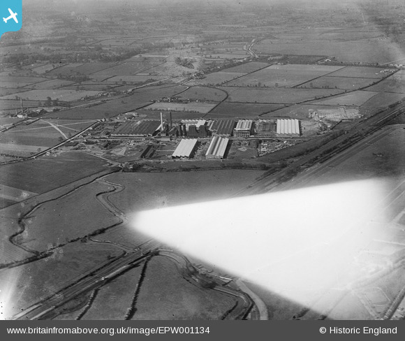
EPW001134 ENGLAND (1920). Fort Dunlop Rubber Works, Bromford, from the south-west, 1920
© Copyright OpenStreetMap contributors and licensed by the OpenStreetMap Foundation. 2026. Cartography is licensed as CC BY-SA.
Nearby Images (2)
EPW001134

EPW060848

Details
| Title | [EPW001134] Fort Dunlop Rubber Works, Bromford, from the south-west, 1920 |
| Reference | EPW001134 |
| Date | May-1920 |
| Link | |
| Place name | BROMFORD |
| Parish | |
| District | |
| Country | ENGLAND |
| Easting / Northing | 411979, 289811 |
| Longitude / Latitude | -1.8234949251284, 52.505697398775 |
| National Grid Reference | SP120898 |
Pins
 |

bfa |
Sunday 7th of October 2012 02:59:35 PM |
|
Steve Cemm |
Tuesday 10th of July 2012 09:26:49 PM | |
|
Steve Cemm |
Tuesday 10th of July 2012 09:24:36 PM | |
|
Steve Cemm |
Tuesday 10th of July 2012 09:23:47 PM | |
I agree - this looks like the location of the multi-story tyre store, the facade of which is all that's left of the Fort Dunlop site. |
bfa |
Sunday 7th of October 2012 02:41:31 PM |
|
Steve Cemm |
Tuesday 10th of July 2012 09:23:05 PM | |
|
Calchfaen |
Tuesday 3rd of July 2012 09:53:37 PM | |
|
Glen37037 |
Tuesday 3rd of July 2012 12:58:10 PM | |
Birmingham to Fazeley canal. |
Steve Cemm |
Tuesday 10th of July 2012 09:28:26 PM |
|
Glen37037 |
Tuesday 3rd of July 2012 12:54:59 PM | |
|
TonyW1960 |
Friday 29th of June 2012 10:26:14 PM |
User Comment Contributions
Thanks everyone, We’ve reviewed your comments and thanks to your help we can update the catalogue. The revised record with the correct location will appear here in due course. Yours, Katy Britain from Above Cataloguing Team Leader |
Katy Whitaker |
Tuesday 23rd of October 2012 10:10:10 AM |
Almost sure it is Birmingham Racecourse - the stands are "under the wing". |
Willocolt |
Tuesday 10th of July 2012 09:59:46 AM |