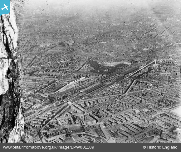
EPW001109 ENGLAND (1920). Hockley Station, Warstone Lane and General Cemeteries area, Birmingham, 1920
© Copyright OpenStreetMap contributors and licensed by the OpenStreetMap Foundation. 2026. Cartography is licensed as CC BY-SA.
Details
| Title | [EPW001109] Hockley Station, Warstone Lane and General Cemeteries area, Birmingham, 1920 |
| Reference | EPW001109 |
| Date | May-1920 |
| Link | |
| Place name | BIRMINGHAM |
| Parish | |
| District | |
| Country | ENGLAND |
| Easting / Northing | 405825, 288184 |
| Longitude / Latitude | -1.9141996062837, 52.491169591469 |
| National Grid Reference | SP058882 |
Pins

edMocass |
Monday 20th of October 2025 11:35:45 AM | |

Paul |
Sunday 6th of July 2025 01:12:16 PM | |

Sasha506 |
Sunday 4th of September 2016 09:32:20 AM | |

Sasha506 |
Sunday 4th of September 2016 09:31:21 AM | |

CombFilter |
Monday 28th of September 2015 03:05:41 PM | |

Rekrap |
Monday 5th of May 2014 02:47:40 PM | |

Rekrap |
Monday 5th of May 2014 02:46:24 PM | |

Rekrap |
Monday 5th of May 2014 02:45:14 PM | |

Rekrap |
Monday 5th of May 2014 02:42:54 PM | |

Rekrap |
Monday 5th of May 2014 07:59:39 AM | |

Rekrap |
Monday 5th of May 2014 07:54:15 AM | |

Rekrap |
Monday 5th of May 2014 07:53:09 AM | |

Rekrap |
Monday 5th of May 2014 07:46:03 AM | |

Rekrap |
Monday 5th of May 2014 07:45:29 AM | |

Rekrap |
Monday 5th of May 2014 07:45:03 AM | |

Rekrap |
Monday 5th of May 2014 07:33:41 AM | |

Rekrap |
Monday 5th of May 2014 07:31:08 AM | |

Rekrap |
Monday 5th of May 2014 07:29:02 AM | |

Rekrap |
Monday 5th of May 2014 07:28:33 AM | |

Rekrap |
Monday 5th of May 2014 07:20:26 AM | |

Rekrap |
Monday 5th of May 2014 07:12:02 AM | |

Rekrap |
Monday 5th of May 2014 07:11:35 AM | |

Rekrap |
Monday 5th of May 2014 07:10:19 AM | |

Rekrap |
Monday 5th of May 2014 07:09:46 AM | |

Rekrap |
Monday 5th of May 2014 07:09:05 AM | |

Rekrap |
Monday 5th of May 2014 07:08:33 AM | |

Rekrap |
Monday 5th of May 2014 07:06:58 AM | |

Rekrap |
Monday 5th of May 2014 07:06:22 AM | |

Rekrap |
Monday 5th of May 2014 07:05:45 AM | |

Rekrap |
Monday 5th of May 2014 07:05:24 AM | |

Rekrap |
Monday 5th of May 2014 07:04:59 AM | |

Rekrap |
Monday 5th of May 2014 07:04:19 AM | |

Rekrap |
Monday 5th of May 2014 07:02:21 AM | |

Rekrap |
Monday 5th of May 2014 07:01:13 AM | |

Rekrap |
Monday 5th of May 2014 06:58:29 AM | |

Rekrap |
Monday 5th of May 2014 06:58:04 AM | |

Rekrap |
Monday 5th of May 2014 06:57:29 AM | |

Rekrap |
Monday 5th of May 2014 06:54:45 AM | |

Rekrap |
Monday 5th of May 2014 06:52:43 AM | |

Rekrap |
Monday 5th of May 2014 06:51:37 AM | |

Rekrap |
Monday 5th of May 2014 06:51:15 AM | |

Rekrap |
Monday 5th of May 2014 06:48:11 AM | |

Glassman |
Friday 30th of August 2013 05:26:45 PM | |

Glassman |
Friday 30th of August 2013 05:24:51 PM | |

Glassman |
Friday 30th of August 2013 05:24:11 PM | |

Glassman |
Thursday 29th of August 2013 08:24:36 AM | |

Glassman |
Thursday 29th of August 2013 08:21:32 AM | |

MikeJI |
Monday 26th of August 2013 12:46:40 PM | |

MikeJI |
Monday 26th of August 2013 12:40:43 PM | |

MikeJI |
Monday 26th of August 2013 12:30:47 PM | |

Glassman |
Wednesday 21st of August 2013 06:46:19 PM | |

Glassman |
Wednesday 21st of August 2013 06:40:23 PM | |

Glassman |
Wednesday 21st of August 2013 06:14:59 PM | |

John Ball |
Wednesday 27th of March 2013 07:50:38 PM | |

Allan |
Saturday 15th of December 2012 03:40:05 PM | |

Bob Johnson |
Wednesday 27th of June 2012 04:21:31 PM | |
Strictly speaking, without being rude, it was at that time Ellen Steet Schools. Demolished by enemy action December 1940. A 1948 picture shows the school raised to the ground |

Brookfields Brummie |
Thursday 20th of February 2014 12:54:53 PM |

Bob Johnson |
Wednesday 27th of June 2012 04:20:06 PM | |

Bob Johnson |
Wednesday 27th of June 2012 04:18:17 PM | |

Bob Johnson |
Wednesday 27th of June 2012 04:16:36 PM | |

Brasspot |
Tuesday 26th of June 2012 07:28:33 PM | |

Brasspot |
Tuesday 26th of June 2012 07:26:21 PM | |
My mother and father were married here during the war |

Brookfields Brummie |
Thursday 20th of February 2014 12:56:10 PM |

Brasspot |
Tuesday 26th of June 2012 07:24:39 PM | |

Brasspot |
Tuesday 26th of June 2012 07:22:11 PM | |

Brasspot |
Tuesday 26th of June 2012 07:20:05 PM | |

Brasspot |
Tuesday 26th of June 2012 07:14:59 PM |


![[EPW001109] Hockley Station, Warstone Lane and General Cemeteries area, Birmingham, 1920](http://britainfromabove.org.uk/sites/all/libraries/aerofilms-images/public/100x100/EPW/001/EPW001109.jpg)
![[EPW062659] A cityscape over Hockley and Brookfields, Birmingham, 1939](http://britainfromabove.org.uk/sites/all/libraries/aerofilms-images/public/100x100/EPW/062/EPW062659.jpg)