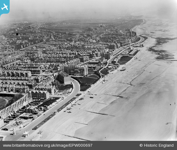
EPW000697 ENGLAND (1920). Bexhill, from the south-west, 1920
© Copyright OpenStreetMap contributors and licensed by the OpenStreetMap Foundation. 2026. Cartography is licensed as CC BY-SA.
Nearby Images (13)
Details
| Title | [EPW000697] Bexhill, from the south-west, 1920 |
| Reference | EPW000697 |
| Date | April-1920 |
| Link | |
| Place name | BEXHILL |
| Parish | |
| District | |
| Country | ENGLAND |
| Easting / Northing | 573909, 106904 |
| Longitude / Latitude | 0.47004833175567, 50.834941386106 |
| National Grid Reference | TQ739069 |
Pins
Be the first to add a comment to this image!


![[EPW000697] Bexhill, from the south-west, 1920](http://britainfromabove.org.uk/sites/all/libraries/aerofilms-images/public/100x100/EPW/000/EPW000697.jpg)
![[EAW006615] The seafront and town, Bexhill, from the south, 1947](http://britainfromabove.org.uk/sites/all/libraries/aerofilms-images/public/100x100/EAW/006/EAW006615.jpg)
![[EPW035331] West Parade and environs, Bexhill, from the west, 1931](http://britainfromabove.org.uk/sites/all/libraries/aerofilms-images/public/100x100/EPW/035/EPW035331.jpg)
![[EPW039350] West Parade and the seafront, Bexhill, from the south-west, 1932](http://britainfromabove.org.uk/sites/all/libraries/aerofilms-images/public/100x100/EPW/039/EPW039350.jpg)
![[EPW026234] The King Edward VII Memorial and Egerton Park, Bexhill, 1929](http://britainfromabove.org.uk/sites/all/libraries/aerofilms-images/public/100x100/EPW/026/EPW026234.jpg)
![[EAW006616] Egerton Park, the seafront and town, Bexhill, from the south-west, 1947](http://britainfromabove.org.uk/sites/all/libraries/aerofilms-images/public/100x100/EAW/006/EAW006616.jpg)
![[EPW035329] The Colonnade and seafront, Bexhill, 1931](http://britainfromabove.org.uk/sites/all/libraries/aerofilms-images/public/100x100/EPW/035/EPW035329.jpg)
![[EPW035330] The Colonnade and environs, Bexhill, 1931](http://britainfromabove.org.uk/sites/all/libraries/aerofilms-images/public/100x100/EPW/035/EPW035330.jpg)
![[EPW026222] The Colonnade, Metropole Hotel and environs, Bexhill, 1929](http://britainfromabove.org.uk/sites/all/libraries/aerofilms-images/public/100x100/EPW/026/EPW026222.jpg)
![[EPW026233] The Colonnade, Metropole Hotel and environs, Bexhill, 1929](http://britainfromabove.org.uk/sites/all/libraries/aerofilms-images/public/100x100/EPW/026/EPW026233.jpg)
![[EPW039349] The Colonnade and Metropole Hotel, Bexhill, 1932](http://britainfromabove.org.uk/sites/all/libraries/aerofilms-images/public/100x100/EPW/039/EPW039349.jpg)
![[EPW000120] The Colonnade, Bexhill, 1920](http://britainfromabove.org.uk/sites/all/libraries/aerofilms-images/public/100x100/EPW/000/EPW000120.jpg)
![[EPW000123] Egerton Park, Bexhill, 1920](http://britainfromabove.org.uk/sites/all/libraries/aerofilms-images/public/100x100/EPW/000/EPW000123.jpg)