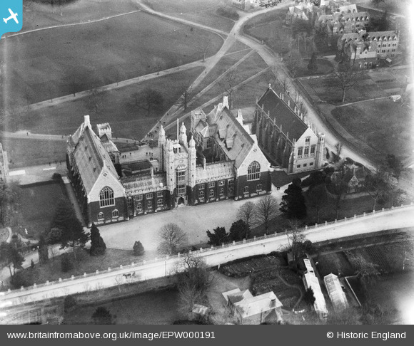
EPW000191 ENGLAND (1920). Malvern College, Great Malvern, 1920
© Copyright OpenStreetMap contributors and licensed by the OpenStreetMap Foundation. 2026. Cartography is licensed as CC BY-SA.
Nearby Images (8)
Details
| Title | [EPW000191] Malvern College, Great Malvern, 1920 |
| Reference | EPW000191 |
| Date | February-1920 |
| Link | |
| Place name | GREAT MALVERN |
| Parish | MALVERN |
| District | |
| Country | ENGLAND |
| Easting / Northing | 377761, 245132 |
| Longitude / Latitude | -2.3247271414508, 52.103660703556 |
| National Grid Reference | SO778451 |
Pins
Be the first to add a comment to this image!
User Comment Contributions
Malvern College (boys) main building (rear) from the North West with College Road left to right in the forground and the College Chapel to the right with part of the extensive grounds and some of the Border's Houses visible upper right plus the Senior Turf to the top middle / left. Happy memories of the period 1961-1966 in House #1 (way off to the left). Looks to be before School House (left lower) and the Memorial Library (middle right) and ? carefully tailored ivy across the main buildings. I see the horse but I had a bike...and Malvern is hilly...[William Eve, Chartered Surveyors] |

William Eve, Chartered Surveyors |
Tuesday 26th of June 2012 11:31:55 PM |


![[EPW000191] Malvern College, Great Malvern, 1920](http://britainfromabove.org.uk/sites/all/libraries/aerofilms-images/public/100x100/EPW/000/EPW000191.jpg)
![[EPW033924] Malvern College, Great Malvern, 1930](http://britainfromabove.org.uk/sites/all/libraries/aerofilms-images/public/100x100/EPW/033/EPW033924.jpg)
![[EPW033925] Malvern College, Great Malvern, 1930](http://britainfromabove.org.uk/sites/all/libraries/aerofilms-images/public/100x100/EPW/033/EPW033925.jpg)
![[EPW041841] Malvern College, Great Malvern, 1933](http://britainfromabove.org.uk/sites/all/libraries/aerofilms-images/public/100x100/EPW/041/EPW041841.jpg)
![[EPW041828] Malvern College, Great Malvern, 1933](http://britainfromabove.org.uk/sites/all/libraries/aerofilms-images/public/100x100/EPW/041/EPW041828.jpg)
![[EPW033917] The town centre overlooked by North Hill, Great Malvern, from the south-east, 1930](http://britainfromabove.org.uk/sites/all/libraries/aerofilms-images/public/100x100/EPW/033/EPW033917.jpg)
![[EPW033915] The town, Great Malvern, from the south, 1930](http://britainfromabove.org.uk/sites/all/libraries/aerofilms-images/public/100x100/EPW/033/EPW033915.jpg)
![[EPW041839] The town, Great Malvern, from the south, 1933](http://britainfromabove.org.uk/sites/all/libraries/aerofilms-images/public/100x100/EPW/041/EPW041839.jpg)