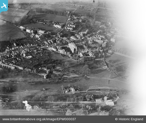
EPW000037 ENGLAND (1920). Eton and Eton College, Eton, 1920
© Copyright OpenStreetMap contributors and licensed by the OpenStreetMap Foundation. 2026. Cartography is licensed as CC BY-SA.
Nearby Images (40)
Details
| Title | [EPW000037] Eton and Eton College, Eton, 1920 |
| Reference | EPW000037 |
| Date | 8-January-1920 |
| Link | |
| Place name | ETON |
| Parish | ETON |
| District | |
| Country | ENGLAND |
| Easting / Northing | 496742, 177867 |
| Longitude / Latitude | -0.60638950114757, 51.490978332106 |
| National Grid Reference | SU967779 |
Pins

sciencefish |
Friday 9th of July 2021 12:35:50 PM | |

Alan McFaden |
Sunday 31st of March 2013 07:17:40 PM | |

Alan McFaden |
Sunday 31st of March 2013 07:17:00 PM | |

Alan McFaden |
Sunday 31st of March 2013 07:15:50 PM | |

Alan McFaden |
Sunday 31st of March 2013 07:14:50 PM | |

Thamesweb |
Saturday 1st of September 2012 06:39:25 PM | |

Thamesweb |
Saturday 1st of September 2012 06:38:06 PM | |

Thamesweb |
Saturday 1st of September 2012 06:37:23 PM | |

Thamesweb |
Saturday 1st of September 2012 06:35:28 PM | |

Thamesweb |
Saturday 1st of September 2012 06:34:41 PM | |

Thamesweb |
Saturday 1st of September 2012 06:33:48 PM |
User Comment Contributions
Eton College Chapel, 07/09/2015 |

Class31 |
Tuesday 8th of September 2015 08:42:16 AM |


![[EPW000037] Eton and Eton College, Eton, 1920](http://britainfromabove.org.uk/sites/all/libraries/aerofilms-images/public/100x100/EPW/000/EPW000037.jpg)
![[EAW006347] Eton College and environs, Eton, 1947](http://britainfromabove.org.uk/sites/all/libraries/aerofilms-images/public/100x100/EAW/006/EAW006347.jpg)
![[EAW006350] Eton College and environs, Eton, 1947](http://britainfromabove.org.uk/sites/all/libraries/aerofilms-images/public/100x100/EAW/006/EAW006350.jpg)
![[EAW006328] Eton College and St Mary's Chapel, Eton, 1947](http://britainfromabove.org.uk/sites/all/libraries/aerofilms-images/public/100x100/EAW/006/EAW006328.jpg)
![[EAW006337] Eton College, Eton, 1947](http://britainfromabove.org.uk/sites/all/libraries/aerofilms-images/public/100x100/EAW/006/EAW006337.jpg)
![[EAW006341] Eton College and St Mary's Chapel, Eton, 1947](http://britainfromabove.org.uk/sites/all/libraries/aerofilms-images/public/100x100/EAW/006/EAW006341.jpg)
![[EAW006339] The High Street and town, St Mary's Chapel and environs, Eton, 1947](http://britainfromabove.org.uk/sites/all/libraries/aerofilms-images/public/100x100/EAW/006/EAW006339.jpg)
![[EAW006338] Eton College, Eton, 1947](http://britainfromabove.org.uk/sites/all/libraries/aerofilms-images/public/100x100/EAW/006/EAW006338.jpg)
![[EAW006336] Eton College, Eton, 1947](http://britainfromabove.org.uk/sites/all/libraries/aerofilms-images/public/100x100/EAW/006/EAW006336.jpg)
![[EAW006332] Eton College, Eton, 1947](http://britainfromabove.org.uk/sites/all/libraries/aerofilms-images/public/100x100/EAW/006/EAW006332.jpg)
![[EAW006329] Eton College, Eton, 1947](http://britainfromabove.org.uk/sites/all/libraries/aerofilms-images/public/100x100/EAW/006/EAW006329.jpg)
![[EAW006335] Eton College, Eton, 1947](http://britainfromabove.org.uk/sites/all/libraries/aerofilms-images/public/100x100/EAW/006/EAW006335.jpg)
![[EAW006330] Eton College, Eton, 1947](http://britainfromabove.org.uk/sites/all/libraries/aerofilms-images/public/100x100/EAW/006/EAW006330.jpg)
![[EAW006333] Eton College, Eton, 1947](http://britainfromabove.org.uk/sites/all/libraries/aerofilms-images/public/100x100/EAW/006/EAW006333.jpg)
![[EPW006211] Eton College, Eton, 1921](http://britainfromabove.org.uk/sites/all/libraries/aerofilms-images/public/100x100/EPW/006/EPW006211.jpg)
![[EPW022612] Eton College and St Mary's Chapel, Eton, 1928](http://britainfromabove.org.uk/sites/all/libraries/aerofilms-images/public/100x100/EPW/022/EPW022612.jpg)
![[EAW006348] Eton College, Eton, 1947](http://britainfromabove.org.uk/sites/all/libraries/aerofilms-images/public/100x100/EAW/006/EAW006348.jpg)
![[EPW022613] Eton College and St Mary's Chapel, Eton, 1928](http://britainfromabove.org.uk/sites/all/libraries/aerofilms-images/public/100x100/EPW/022/EPW022613.jpg)
![[EAW006331] Eton College, Eton, 1947](http://britainfromabove.org.uk/sites/all/libraries/aerofilms-images/public/100x100/EAW/006/EAW006331.jpg)
![[EAW006352] Eton College and environs, Eton, 1947](http://britainfromabove.org.uk/sites/all/libraries/aerofilms-images/public/100x100/EAW/006/EAW006352.jpg)
![[EPW022611] Eton College and St Mary's Chapel, Eton, 1928](http://britainfromabove.org.uk/sites/all/libraries/aerofilms-images/public/100x100/EPW/022/EPW022611.jpg)
![[EPW056586] Eton College and the town, Eton, 1938](http://britainfromabove.org.uk/sites/all/libraries/aerofilms-images/public/100x100/EPW/056/EPW056586.jpg)
![[EAW006349] Eton College, Eton, 1947](http://britainfromabove.org.uk/sites/all/libraries/aerofilms-images/public/100x100/EAW/006/EAW006349.jpg)
![[EAW006343] Eton College, Eton, 1947](http://britainfromabove.org.uk/sites/all/libraries/aerofilms-images/public/100x100/EAW/006/EAW006343.jpg)
![[EAW006353] Eton College and environs, Eton, 1947. This image has been affected by flare.](http://britainfromabove.org.uk/sites/all/libraries/aerofilms-images/public/100x100/EAW/006/EAW006353.jpg)
![[EAW006351] Eton College and environs, Eton, 1947](http://britainfromabove.org.uk/sites/all/libraries/aerofilms-images/public/100x100/EAW/006/EAW006351.jpg)
![[EAW026472] The town, Eton, 1949](http://britainfromabove.org.uk/sites/all/libraries/aerofilms-images/public/100x100/EAW/026/EAW026472.jpg)
![[EAW006355] Eton College and environs, Eton, 1947. This image has been affected by flare.](http://britainfromabove.org.uk/sites/all/libraries/aerofilms-images/public/100x100/EAW/006/EAW006355.jpg)
![[EAW052779] Eton College, Eton, 1953](http://britainfromabove.org.uk/sites/all/libraries/aerofilms-images/public/100x100/EAW/052/EAW052779.jpg)
![[EAW026471] Eton College and environs, Eton, 1949](http://britainfromabove.org.uk/sites/all/libraries/aerofilms-images/public/100x100/EAW/026/EAW026471.jpg)
![[EPW031204] The River Thames flood at Eton College and St Mary's Chapel, Eton, 1929](http://britainfromabove.org.uk/sites/all/libraries/aerofilms-images/public/100x100/EPW/031/EPW031204.jpg)
![[EAW006354] Eton College and environs, Eton, 1947](http://britainfromabove.org.uk/sites/all/libraries/aerofilms-images/public/100x100/EAW/006/EAW006354.jpg)
![[EPW000038] Eton and Eton College, Eton, 1920](http://britainfromabove.org.uk/sites/all/libraries/aerofilms-images/public/100x100/EPW/000/EPW000038.jpg)
![[EAW006334] Eton College with Windsor Castle in the distance, Eton, from the north, 1947](http://britainfromabove.org.uk/sites/all/libraries/aerofilms-images/public/100x100/EAW/006/EAW006334.jpg)
![[EAW003710] St Mary's Chapel and the surrounding flooded area, Eton, 1947](http://britainfromabove.org.uk/sites/all/libraries/aerofilms-images/public/100x100/EAW/003/EAW003710.jpg)
![[EAW006345] Eton College, Eton, 1947](http://britainfromabove.org.uk/sites/all/libraries/aerofilms-images/public/100x100/EAW/006/EAW006345.jpg)
![[EAW006346] Eton College, Eton, 1947](http://britainfromabove.org.uk/sites/all/libraries/aerofilms-images/public/100x100/EAW/006/EAW006346.jpg)
![[EAW006342] Eton College and the Castle Water Works, Windsor, from the east, 1947](http://britainfromabove.org.uk/sites/all/libraries/aerofilms-images/public/100x100/EAW/006/EAW006342.jpg)
![[EAW006344] Eton College, Eton, 1947](http://britainfromabove.org.uk/sites/all/libraries/aerofilms-images/public/100x100/EAW/006/EAW006344.jpg)
![[EAW006357] The River Thames, Eton College and environs, Eton, from the east, 1947](http://britainfromabove.org.uk/sites/all/libraries/aerofilms-images/public/100x100/EAW/006/EAW006357.jpg)


