
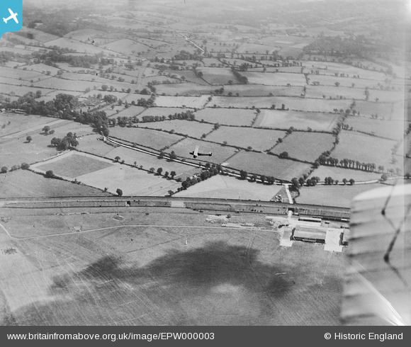
EPW000003 ENGLAND (1919). Aerodrome, Hendon, 1919
© Copyright OpenStreetMap contributors and licensed by the OpenStreetMap Foundation. 2026. Cartography is licensed as CC BY-SA.
Details
| Title | [EPW000003] Aerodrome, Hendon, 1919 |
| Reference | EPW000003 |
| Date | 26-July-1919 |
| Link | |
| Place name | HENDON |
| Parish | |
| District | |
| Country | ENGLAND |
| Easting / Northing | 522305, 190699 |
| Longitude / Latitude | -0.23385029135743, 51.601362328292 |
| National Grid Reference | TQ223907 |
Pins

eric |
Thursday 4th of April 2024 03:25:35 PM | |
|
ken |
Monday 15th of June 2015 07:33:05 PM | |
It actually continued beyond this point to the Airco factory site on the east side of the Edgware Road (next to the old tram depot). |
The Laird |
Thursday 4th of January 2018 06:34:35 PM |

clippedwings |
Saturday 18th of January 2014 10:43:28 AM | |
|
JC |
Friday 20th of July 2012 11:37:17 PM | |
|
JC |
Friday 20th of July 2012 11:25:21 PM | |
|
JC |
Friday 20th of July 2012 11:20:14 PM | |
|
JC |
Friday 20th of July 2012 11:12:15 PM | |
|
JC |
Friday 20th of July 2012 09:43:57 PM | |
|
JC |
Friday 20th of July 2012 09:40:06 PM | |
|
JC |
Friday 20th of July 2012 09:30:17 PM | |
|
JC |
Friday 20th of July 2012 09:05:12 PM | |
|
JC |
Friday 20th of July 2012 09:04:38 PM | |
|
JC |
Friday 20th of July 2012 09:04:01 PM | |
|
JC |
Friday 20th of July 2012 09:03:08 PM | |
|
JC |
Friday 20th of July 2012 09:02:36 PM |
User Comment Contributions

from Wikipedia: Hendon Aerodrome: In November 1916, the War Office commandeered the flying schools, after which the aerodrome trained 490 pilots. Claude Grahame-White and other members of the Royal Naval Air Service (RNAS) mounted a night defence of London in 1915, constituting the very first aerial defence of London. |
TomRobin |
Friday 25th of July 2014 01:33:54 PM |
Also I just noticed, if you zoom into the top left corner of the picture, you can make out Inglis Barracks at the top of Bittacy Hill |
JC |
Friday 20th of July 2012 12:35:55 PM |
This is a view looking eastwards from Hendon Aerodrome over Copthall towards Mill Hill East. The lane running across the centre of the picture is Hall Lane, and it turns into Page Street where it enters the trees on the left. Centre top is Sanders Lane, Mill Hill, the light strip running upwards right to left at about 45 degrees. In the haze just to the right of this you can just make out the old Gasometer where Waitrose is today. |
JC |
Friday 20th of July 2012 12:31:40 PM |