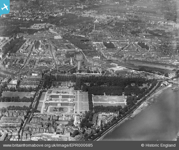
EPR000685 ENGLAND (1935). A cityscape over the Royal Hospital towards Westminster, Chelsea, 1935
© Copyright OpenStreetMap contributors and licensed by the OpenStreetMap Foundation. 2026. Cartography is licensed as CC BY-SA.
Nearby Images (10)
Details
| Title | [EPR000685] A cityscape over the Royal Hospital towards Westminster, Chelsea, 1935 |
| Reference | EPR000685 |
| Date | 24-June-1935 |
| Link | |
| Place name | CHELSEA |
| Parish | |
| District | |
| Country | ENGLAND |
| Easting / Northing | 528283, 178202 |
| Longitude / Latitude | -0.15212884289268, 51.487712326318 |
| National Grid Reference | TQ283782 |
Pins

christhewino |
Thursday 11th of June 2015 09:46:31 PM | |

Gone2Kent |
Thursday 11th of June 2015 06:26:03 PM | |

Gone2Kent |
Thursday 11th of June 2015 06:25:23 PM | |

Gone2Kent |
Thursday 11th of June 2015 06:24:38 PM | |

Gone2Kent |
Thursday 11th of June 2015 06:24:36 PM |


![[EPR000685] A cityscape over the Royal Hospital towards Westminster, Chelsea, 1935](http://britainfromabove.org.uk/sites/all/libraries/aerofilms-images/public/100x100/EPR/000/EPR000685.jpg)
![[EAW049386] The Chelsea Flower Show, Royal Hospital and Ranelagh Gardens, Chelsea, 1953](http://britainfromabove.org.uk/sites/all/libraries/aerofilms-images/public/100x100/EAW/049/EAW049386.jpg)
![[EAW049387] The Chelsea Flower Show, Royal Hospital and Ranelagh Gardens, Chelsea, 1953](http://britainfromabove.org.uk/sites/all/libraries/aerofilms-images/public/100x100/EAW/049/EAW049387.jpg)
![[EPW037942] Chelsea, The Chelsea Flower Show, 1932](http://britainfromabove.org.uk/sites/all/libraries/aerofilms-images/public/100x100/EPW/037/EPW037942.jpg)
![[EPW006309] View of Belgravia and Buckingham Palace, Westminster, from the south-west, 1921](http://britainfromabove.org.uk/sites/all/libraries/aerofilms-images/public/100x100/EPW/006/EPW006309.jpg)
![[EPW024249] The Royal Hospital, Chelsea, 1928](http://britainfromabove.org.uk/sites/all/libraries/aerofilms-images/public/100x100/EPW/024/EPW024249.jpg)
![[EAW049388] The Chelsea Flower Show, Royal Hospital, Ranelagh Gardens and the River Thames, Chelsea, 1953](http://britainfromabove.org.uk/sites/all/libraries/aerofilms-images/public/100x100/EAW/049/EAW049388.jpg)
![[EAW049459] The Chelsea Flower Show, Royal Hospital, Ranelagh Gardens and environs, Chelsea, 1953](http://britainfromabove.org.uk/sites/all/libraries/aerofilms-images/public/100x100/EAW/049/EAW049459.jpg)
![[EAW049458] The Chelsea Flower Show, Royal Hospital, Ranelagh Gardens and environs, Chelsea, 1953](http://britainfromabove.org.uk/sites/all/libraries/aerofilms-images/public/100x100/EAW/049/EAW049458.jpg)
![[EAW049461] The Chelsea Flower Show, Royal Hospital and environs, Chelsea, 1953](http://britainfromabove.org.uk/sites/all/libraries/aerofilms-images/public/100x100/EAW/049/EAW049461.jpg)