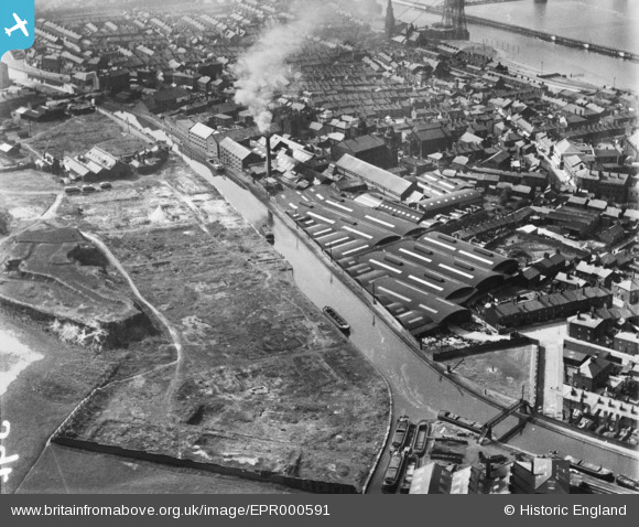
EPR000591 ENGLAND (1935). The Bridgewater Canal and Camden Tannery, Runcorn, 1935
© Copyright OpenStreetMap contributors and licensed by the OpenStreetMap Foundation. 2026. Cartography is licensed as CC BY-SA.
Nearby Images (9)
Details
| Title | [EPR000591] The Bridgewater Canal and Camden Tannery, Runcorn, 1935 |
| Reference | EPR000591 |
| Date | 10-May-1935 |
| Link | |
| Place name | RUNCORN |
| Parish | |
| District | |
| Country | ENGLAND |
| Easting / Northing | 351422, 382854 |
| Longitude / Latitude | -2.7296741858302, 53.340085831328 |
| National Grid Reference | SJ514829 |
Pins

Ginger79 |
Wednesday 22nd of November 2023 01:53:39 AM | |

Ginger79 |
Wednesday 22nd of November 2023 01:51:45 AM | |

Ginger79 |
Wednesday 22nd of November 2023 01:50:58 AM | |

david |
Sunday 19th of April 2015 01:48:17 AM | |

david |
Sunday 19th of April 2015 01:45:31 AM |


![[EPR000591] The Bridgewater Canal and Camden Tannery, Runcorn, 1935](http://britainfromabove.org.uk/sites/all/libraries/aerofilms-images/public/100x100/EPR/000/EPR000591.jpg)
![[EPR000592] The Bridgewater Canal and Camden Tannery, Runcorn, 1935. This image was marked by Aero Pictorial Ltd for photo editing.](http://britainfromabove.org.uk/sites/all/libraries/aerofilms-images/public/100x100/EPR/000/EPR000592.jpg)
![[EPW021651] Camden Tannery and the town, Runcorn, 1928](http://britainfromabove.org.uk/sites/all/libraries/aerofilms-images/public/100x100/EPW/021/EPW021651.jpg)
![[EPR000593] The Bridgewater Canal, Camden Tannery and environs, Runcorn, 1935. This image was marked by Aero Pictorial Ltd for photo editing.](http://britainfromabove.org.uk/sites/all/libraries/aerofilms-images/public/100x100/EPR/000/EPR000593.jpg)
![[EPR000590] The Bridgewater Canal and northern part of the town, Runcorn, 1935](http://britainfromabove.org.uk/sites/all/libraries/aerofilms-images/public/100x100/EPR/000/EPR000590.jpg)
![[EAW023485] The area between the Manchester Ship Canal and Bridgewater Canal by Camden Tannery and environs, Runcorn, 1949](http://britainfromabove.org.uk/sites/all/libraries/aerofilms-images/public/100x100/EAW/023/EAW023485.jpg)
![[EAW021990] The area between the Bridgwater Canal and Manchester Ship Canal, Runcorn, 1949](http://britainfromabove.org.uk/sites/all/libraries/aerofilms-images/public/100x100/EAW/021/EAW021990.jpg)
![[EPW018919] Holy Trinity Church and the Market Place, Runcorn, 1927](http://britainfromabove.org.uk/sites/all/libraries/aerofilms-images/public/100x100/EPW/018/EPW018919.jpg)
![[EAW023481] The area around Runcorn Cemetery and Big Pool, Runcorn, 1949](http://britainfromabove.org.uk/sites/all/libraries/aerofilms-images/public/100x100/EAW/023/EAW023481.jpg)
