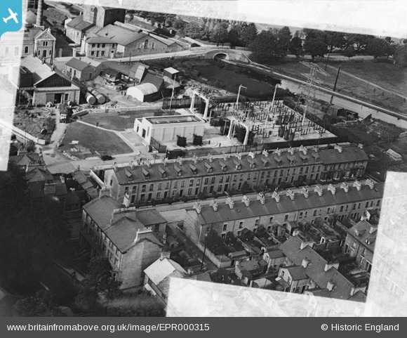
EPR000315 ENGLAND (1934). The Kendal Corporation Electricity Department Transformer Station and Works alongside Lound Street, Kendal, 1934. This image was marked by Aero Pictorial Ltd for photo editing.
© Copyright OpenStreetMap contributors and licensed by the OpenStreetMap Foundation. 2026. Cartography is licensed as CC BY-SA.
Nearby Images (6)
Details
| Title | [EPR000315] The Kendal Corporation Electricity Department Transformer Station and Works alongside Lound Street, Kendal, 1934. This image was marked by Aero Pictorial Ltd for photo editing. |
| Reference | EPR000315 |
| Date | 30-August-1934 |
| Link | |
| Place name | KENDAL |
| Parish | KENDAL |
| District | |
| Country | ENGLAND |
| Easting / Northing | 351868, 491795 |
| Longitude / Latitude | -2.7400366956936, 54.319313690554 |
| National Grid Reference | SD519918 |
Pins

Moonraker |
Wednesday 18th of October 2023 10:01:01 AM |


![[EPR000315] The Kendal Corporation Electricity Department Transformer Station and Works alongside Lound Street, Kendal, 1934. This image was marked by Aero Pictorial Ltd for photo editing.](http://britainfromabove.org.uk/sites/all/libraries/aerofilms-images/public/100x100/EPR/000/EPR000315.jpg)
![[EPR000317] The Kendal Corporation Electricity Department Transformer Station and Works alongside Lound Street, Kendal, 1934](http://britainfromabove.org.uk/sites/all/libraries/aerofilms-images/public/100x100/EPR/000/EPR000317.jpg)
![[EPR000314] The Kendal Corporation Electricity Department Transformer Station and Works off Park Side Road, Kendal, 1934. This image was marked by Aero Pictorial Ltd for photo editing.](http://britainfromabove.org.uk/sites/all/libraries/aerofilms-images/public/100x100/EPR/000/EPR000314.jpg)
![[EPR000312] The Kendal Corporation Electricity Department Transformer Station and Works off Park Side Road, Kendal, 1934](http://britainfromabove.org.uk/sites/all/libraries/aerofilms-images/public/100x100/EPR/000/EPR000312.jpg)
![[EPR000313] The Kendal Corporation Electricity Department Transformer Station and Works off Park Side Road, Kendal, 1934. This image was marked by Aero Pictorial Ltd for photo editing.](http://britainfromabove.org.uk/sites/all/libraries/aerofilms-images/public/100x100/EPR/000/EPR000313.jpg)
![[EPR000091] The Kendal Corporation Electricity Department Transformer Station and Works off Park Side Road, Kendal, 1934](http://britainfromabove.org.uk/sites/all/libraries/aerofilms-images/public/100x100/EPR/000/EPR000091.jpg)