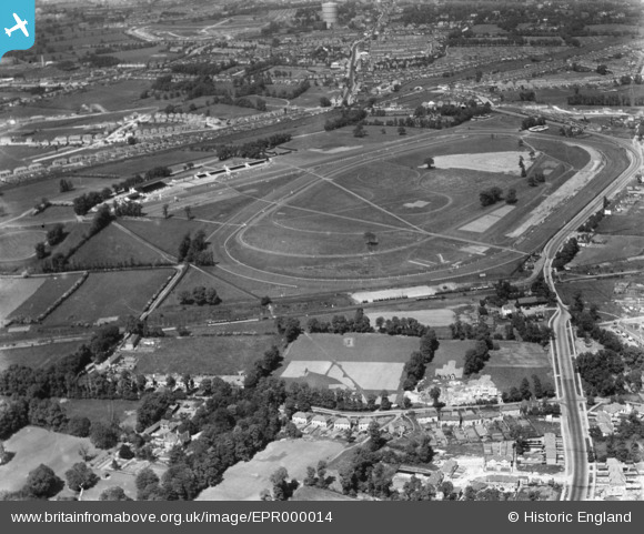
EPR000014 ENGLAND (1934). Northolt Park Race Course, Northolt, 1934
© Copyright OpenStreetMap contributors and licensed by the OpenStreetMap Foundation. 2026. Cartography is licensed as CC BY-SA.
Nearby Images (16)
Details
| Title | [EPR000014] Northolt Park Race Course, Northolt, 1934 |
| Reference | EPR000014 |
| Date | 30-May-1934 |
| Link | |
| Place name | NORTHOLT |
| Parish | |
| District | |
| Country | ENGLAND |
| Easting / Northing | 513126, 184741 |
| Longitude / Latitude | -0.36825898248092, 51.549726411119 |
| National Grid Reference | TQ131847 |
Pins

Leslie B |
Saturday 14th of August 2021 10:26:10 PM | |

Leslie B |
Saturday 14th of August 2021 10:25:23 PM | |

JOHN |
Sunday 31st of December 2017 02:34:57 PM | |

Des Elmes |
Tuesday 5th of April 2016 02:14:33 AM | |

Des Elmes |
Tuesday 5th of April 2016 02:13:41 AM | |

Des Elmes |
Tuesday 5th of April 2016 02:12:08 AM | |

Des Elmes |
Tuesday 5th of April 2016 02:10:59 AM | |

Des Elmes |
Tuesday 5th of April 2016 02:10:27 AM |


![[EPR000014] Northolt Park Race Course, Northolt, 1934](http://britainfromabove.org.uk/sites/all/libraries/aerofilms-images/public/100x100/EPR/000/EPR000014.jpg)
![[EPW040793] Northolt Park Racecourse, Northolt, from the south-west, 1933](http://britainfromabove.org.uk/sites/all/libraries/aerofilms-images/public/100x100/EPW/040/EPW040793.jpg)
![[EPW040795] Northolt Park Racecourse, Northolt, from the south-west, 1933](http://britainfromabove.org.uk/sites/all/libraries/aerofilms-images/public/100x100/EPW/040/EPW040795.jpg)
![[EPW040796] Northolt Park Racecourse, Northolt, from the south-west, 1933](http://britainfromabove.org.uk/sites/all/libraries/aerofilms-images/public/100x100/EPW/040/EPW040796.jpg)
![[EPW040797] Northolt Park Racecourse, Northolt, from the south-west, 1933](http://britainfromabove.org.uk/sites/all/libraries/aerofilms-images/public/100x100/EPW/040/EPW040797.jpg)
![[EPW040901] Northolt Park Race Course, Northolt, 1933](http://britainfromabove.org.uk/sites/all/libraries/aerofilms-images/public/100x100/EPW/040/EPW040901.jpg)
![[EPW044270] Northolt Park Racecourse, Northolt, 1934. This image has been produced from a damaged negative.](http://britainfromabove.org.uk/sites/all/libraries/aerofilms-images/public/100x100/EPW/044/EPW044270.jpg)
![[EPW044271] Northolt Park Racecourse and environs, Northolt, 1934](http://britainfromabove.org.uk/sites/all/libraries/aerofilms-images/public/100x100/EPW/044/EPW044271.jpg)
![[EPW040794] Northolt Park Racecourse, Northolt, from the south-west, 1933](http://britainfromabove.org.uk/sites/all/libraries/aerofilms-images/public/100x100/EPW/040/EPW040794.jpg)
![[EPW040792] Northolt Park Racecourse, Northolt, from the south, 1933](http://britainfromabove.org.uk/sites/all/libraries/aerofilms-images/public/100x100/EPW/040/EPW040792.jpg)
![[EPR000013] Northolt Park Race Course, Northolt, 1934](http://britainfromabove.org.uk/sites/all/libraries/aerofilms-images/public/100x100/EPR/000/EPR000013.jpg)
![[EPW035056] Northolt Park Race Course and environs, Northolt, from the south, 1931](http://britainfromabove.org.uk/sites/all/libraries/aerofilms-images/public/100x100/EPW/035/EPW035056.jpg)
![[EPW040902] Northolt Park Race Course, Northolt, 1933](http://britainfromabove.org.uk/sites/all/libraries/aerofilms-images/public/100x100/EPW/040/EPW040902.jpg)
![[EPW044273] Northolt Park Racecourse and environs, Northolt, 1934](http://britainfromabove.org.uk/sites/all/libraries/aerofilms-images/public/100x100/EPW/044/EPW044273.jpg)
![[EPW040900] Northolt Park Race Course, Northolt, 1933](http://britainfromabove.org.uk/sites/all/libraries/aerofilms-images/public/100x100/EPW/040/EPW040900.jpg)
![[EPW044554] Northolt Park Race Course, Northolt, 1934](http://britainfromabove.org.uk/sites/all/libraries/aerofilms-images/public/100x100/EPW/044/EPW044554.jpg)