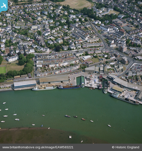
EAW583221 ENGLAND (1990). Marina, Teignmouth, Devon, 1990
© Copyright OpenStreetMap contributors and licensed by the OpenStreetMap Foundation. 2026. Cartography is licensed as CC BY-SA.
Nearby Images (5)
Details
| Title | [EAW583221] Marina, Teignmouth, Devon, 1990 |
| Reference | EAW583221 |
| Date | 23-July-1990 |
| Link | |
| Place name | TEIGNMOUTH |
| Parish | TEIGNMOUTH |
| District | |
| Country | ENGLAND |
| Easting / Northing | 293666, 72984 |
| Longitude / Latitude | -3.5009747671006, 50.546347054299 |
| National Grid Reference | SX937730 |
Pins

Sco172 |
Tuesday 20th of February 2024 01:17:48 PM | |

John W |
Sunday 15th of September 2019 10:20:36 PM | |

Billy Turner |
Monday 26th of September 2016 09:41:50 PM | |

Billy Turner |
Monday 26th of September 2016 08:05:37 PM | |

Billy Turner |
Monday 26th of September 2016 07:51:00 PM | |

Billy Turner |
Monday 26th of September 2016 07:37:33 PM | |

Billy Turner |
Monday 26th of September 2016 07:36:07 PM | |

Billy Turner |
Monday 26th of September 2016 07:35:42 PM | |

John W |
Friday 26th of August 2016 09:35:58 PM |
User Comment Contributions
Note the complete loss of any railway connection to the main line - most of the quay buildings have been rebuilt as well when compared to the previous pictures. The quay to the right was being used for commercial cargo carrying when the photo was taken; I don't know if that traffic is still on-going. |

John W |
Monday 6th of June 2016 08:52:41 PM |


![[EAW583221] Marina, Teignmouth, Devon, 1990](http://britainfromabove.org.uk/sites/all/libraries/aerofilms-images/public/100x100/EAW/583/EAW583221.jpg)
![[EPW033436] The Old Quay and housing off Bitton Street, Teignmouth, 1930](http://britainfromabove.org.uk/sites/all/libraries/aerofilms-images/public/100x100/EPW/033/EPW033436.jpg)
![[EPW024187] Old Quay, Teignmouth, 1928](http://britainfromabove.org.uk/sites/all/libraries/aerofilms-images/public/100x100/EPW/024/EPW024187.jpg)
![[EPW024218] St James's Church, the railway and the town, Teignmouth, 1928](http://britainfromabove.org.uk/sites/all/libraries/aerofilms-images/public/100x100/EPW/024/EPW024218.jpg)
![[EPW033441] The town, Teignmouth, 1930](http://britainfromabove.org.uk/sites/all/libraries/aerofilms-images/public/100x100/EPW/033/EPW033441.jpg)


