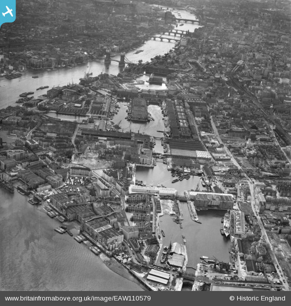
EAW110579 ENGLAND (1963). Shadwell Basin, London, 1963
© Copyright OpenStreetMap contributors and licensed by the OpenStreetMap Foundation. 2026. Cartography is licensed as CC BY-SA.
Nearby Images (6)
Details
| Title | [EAW110579] Shadwell Basin, London, 1963 |
| Reference | EAW110579 |
| Date | 3-May-1963 |
| Link | |
| Place name | WAPPING |
| Parish | NON CIVIL PARISH |
| District | |
| Country | ENGLAND |
| Easting / Northing | 534772, 180536 |
| Longitude / Latitude | -0.05782178731662, 51.507179274171 |
| National Grid Reference | TQ348805 |
Pins

Robin |
Saturday 7th of December 2024 04:51:58 PM | |

Class31 |
Tuesday 31st of May 2016 02:23:34 PM | |

Pootling Around |
Tuesday 31st of May 2016 01:03:50 PM | |

Pootling Around |
Tuesday 31st of May 2016 01:03:05 PM | |

Pootling Around |
Tuesday 31st of May 2016 01:01:18 PM | |

Pootling Around |
Tuesday 31st of May 2016 01:00:25 PM | |

Pootling Around |
Tuesday 31st of May 2016 12:59:26 PM | |

Pootling Around |
Tuesday 31st of May 2016 12:58:42 PM | |

Pootling Around |
Tuesday 31st of May 2016 12:57:30 PM | |

Pootling Around |
Tuesday 31st of May 2016 12:56:58 PM | |

Pootling Around |
Tuesday 31st of May 2016 12:56:26 PM | |

billybuttons |
Tuesday 1st of December 2015 09:02:00 PM | |

billybuttons |
Tuesday 1st of December 2015 08:57:58 PM |


![[EAW110579] Shadwell Basin, London, 1963](http://britainfromabove.org.uk/sites/all/libraries/aerofilms-images/public/100x100/EAW/110/EAW110579.jpg)
![[EPW044139] The London Docks and environs, Wapping, 1934](http://britainfromabove.org.uk/sites/all/libraries/aerofilms-images/public/100x100/EPW/044/EPW044139.jpg)
![[EPW044138] The London Docks, River Thames and environs, Wapping, 1934](http://britainfromabove.org.uk/sites/all/libraries/aerofilms-images/public/100x100/EPW/044/EPW044138.jpg)
![[EAW021444] The London Docks and St George in the East, Wapping, 1949](http://britainfromabove.org.uk/sites/all/libraries/aerofilms-images/public/100x100/EAW/021/EAW021444.jpg)
![[EAW022335] The London Docks and Shadwell district, Wapping, from the south, 1949](http://britainfromabove.org.uk/sites/all/libraries/aerofilms-images/public/100x100/EAW/022/EAW022335.jpg)
![[EPW007729] St George's in the East Workhouse and dockside warehouses, Wapping, 1922](http://britainfromabove.org.uk/sites/all/libraries/aerofilms-images/public/100x100/EPW/007/EPW007729.jpg)
