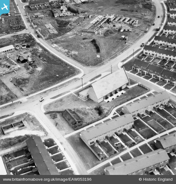
EAW053196 ENGLAND (1954). St Andrew's Church on Bedwell Crescent, Stevenage, 1954
© Copyright OpenStreetMap contributors and licensed by the OpenStreetMap Foundation. 2026. Cartography is licensed as CC BY-SA.
Nearby Images (9)
Details
| Title | [EAW053196] St Andrew's Church on Bedwell Crescent, Stevenage, 1954 |
| Reference | EAW053196 |
| Date | 10-March-1954 |
| Link | |
| Place name | STEVENAGE |
| Parish | |
| District | |
| Country | ENGLAND |
| Easting / Northing | 524571, 224125 |
| Longitude / Latitude | -0.18916731285259, 51.901286998614 |
| National Grid Reference | TL246241 |
Pins

andy |
Tuesday 23rd of July 2019 09:25:54 AM | |

Billy Turner |
Wednesday 9th of November 2016 03:32:55 PM | |

Billy Turner |
Tuesday 8th of November 2016 08:36:30 PM |


![[EAW053196] St Andrew's Church on Bedwell Crescent, Stevenage, 1954](http://britainfromabove.org.uk/sites/all/libraries/aerofilms-images/public/100x100/EAW/053/EAW053196.jpg)
![[EAW053197] St Andrew's Church on Bedwell Crescent, Stevenage, 1954](http://britainfromabove.org.uk/sites/all/libraries/aerofilms-images/public/100x100/EAW/053/EAW053197.jpg)
![[EAW053198] St Andrew's Church on Bedwell Crescent, Stevenage, 1954](http://britainfromabove.org.uk/sites/all/libraries/aerofilms-images/public/100x100/EAW/053/EAW053198.jpg)
![[EAW047260] The residential areas at Whomerley Wood and Bedwell East under construction, Bedwell, from the south-west, 1952. This image was marked by Aerofilms Ltd for photo editing.](http://britainfromabove.org.uk/sites/all/libraries/aerofilms-images/public/100x100/EAW/047/EAW047260.jpg)
![[EAW047265] The residential areas at Whomerley Wood and Bedwell North under construction, Bedwell, from the south-west, 1952](http://britainfromabove.org.uk/sites/all/libraries/aerofilms-images/public/100x100/EAW/047/EAW047265.jpg)
![[EAW047264] The residential areas at Whomerley Wood and Bedwell North under construction, Bedwell, 1952](http://britainfromabove.org.uk/sites/all/libraries/aerofilms-images/public/100x100/EAW/047/EAW047264.jpg)
![[EAW047262] The residential areas at Whomerley Wood and Bedwell East under construction, Bedwell, from the south-west, 1952](http://britainfromabove.org.uk/sites/all/libraries/aerofilms-images/public/100x100/EAW/047/EAW047262.jpg)
![[EAW047263] The residential areas at Whomerley Wood and Bedwell North under construction, Bedwell, from the south-west, 1952](http://britainfromabove.org.uk/sites/all/libraries/aerofilms-images/public/100x100/EAW/047/EAW047263.jpg)
![[EAW047261] The residential areas at Whomerley Wood and Bedwell North under construction, Bedwell, from the south, 1952](http://britainfromabove.org.uk/sites/all/libraries/aerofilms-images/public/100x100/EAW/047/EAW047261.jpg)

