
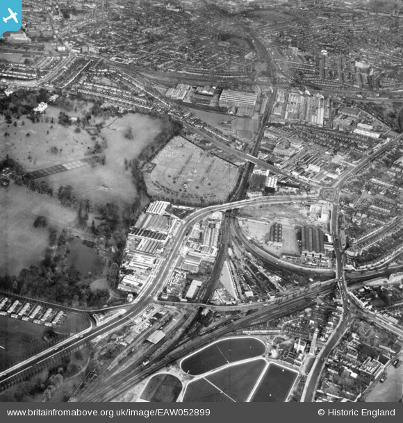
EAW052899 ENGLAND (1953). The Great West Road, Kensington Cemetery and the surrounding industrial area, Brentford, 1953
© Copyright OpenStreetMap contributors and licensed by the OpenStreetMap Foundation. 2026. Cartography is licensed as CC BY-SA.
Nearby Images (19)
EAW052899

EAW052943

EAW052909

EAW052900

EAW052940

EAW052898

EAW052939

EAW052942

EAW052901

EAW052908

EAW052936

EAW052937

EAW052903

EAW052935

EAW052904

EAW052944

EAW052905

EPW037583

EAW052902

Details
| Title | [EAW052899] The Great West Road, Kensington Cemetery and the surrounding industrial area, Brentford, 1953 |
| Reference | EAW052899 |
| Date | 3-November-1953 |
| Link | |
| Place name | BRENTFORD |
| Parish | |
| District | |
| Country | ENGLAND |
| Easting / Northing | 519052, 178546 |
| Longitude / Latitude | -0.28491553286143, 51.492823573177 |
| National Grid Reference | TQ191785 |
Pins

Leslie B |
Thursday 22nd of December 2022 04:29:59 PM | |
|
Leslie B |
Thursday 22nd of December 2022 04:29:17 PM | |
|
Leslie B |
Thursday 22nd of December 2022 04:27:59 PM | |
|
Leslie B |
Thursday 22nd of December 2022 04:26:54 PM | |
|
Leslie B |
Thursday 22nd of December 2022 04:26:11 PM |