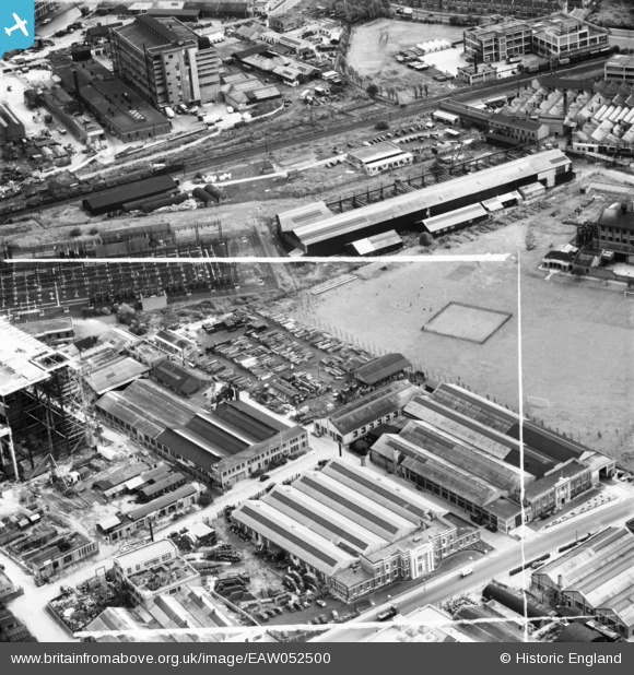
EAW052500 ENGLAND (1953). The Expandite Ltd Works, other factories and the nearby Sports Ground, North Acton, 1953. This image was marked by Aerofilms Ltd for photo editing.
© Copyright OpenStreetMap contributors and licensed by the OpenStreetMap Foundation. 2026. Cartography is licensed as CC BY-SA.
Nearby Images (48)
Details
| Title | [EAW052500] The Expandite Ltd Works, other factories and the nearby Sports Ground, North Acton, 1953. This image was marked by Aerofilms Ltd for photo editing. |
| Reference | EAW052500 |
| Date | 30-September-1953 |
| Link | |
| Place name | NORTH ACTON |
| Parish | |
| District | |
| Country | ENGLAND |
| Easting / Northing | 520998, 182612 |
| Longitude / Latitude | -0.25549926165262, 51.52895689569 |
| National Grid Reference | TQ210826 |
Pins
Be the first to add a comment to this image!


![[EAW052501] The Expandite Ltd Works, other factories and the nearby Sports Ground, North Acton, 1953. This image was marked by Aerofilms Ltd for photo editing.](http://britainfromabove.org.uk/sites/all/libraries/aerofilms-images/public/100x100/EAW/052/EAW052501.jpg)
![[EAW052503] The Expandite Ltd Works and other factories, North Acton, 1953. This image was marked by Aerofilms Ltd for photo editing.](http://britainfromabove.org.uk/sites/all/libraries/aerofilms-images/public/100x100/EAW/052/EAW052503.jpg)
![[EAW009109] The Mond Nickel Co Refinery on Bashley Road and environs, North Acton, 1947](http://britainfromabove.org.uk/sites/all/libraries/aerofilms-images/public/100x100/EAW/009/EAW009109.jpg)
![[EAW009099] The Mond Nickel Co Refinery on Bashley Road and environs, North Acton, 1947](http://britainfromabove.org.uk/sites/all/libraries/aerofilms-images/public/100x100/EAW/009/EAW009099.jpg)
![[EAW009106] The Mond Nickel Co Refinery on Bashley Road and environs, North Acton, 1947](http://britainfromabove.org.uk/sites/all/libraries/aerofilms-images/public/100x100/EAW/009/EAW009106.jpg)
![[EAW052497] The Expandite Ltd Works and other factories, North Acton, 1953. This image was marked by Aerofilms Ltd for photo editing.](http://britainfromabove.org.uk/sites/all/libraries/aerofilms-images/public/100x100/EAW/052/EAW052497.jpg)
![[EAW052499] The Expandite Ltd Works and other factories, North Acton, 1953. This image was marked by Aerofilms Ltd for photo editing.](http://britainfromabove.org.uk/sites/all/libraries/aerofilms-images/public/100x100/EAW/052/EAW052499.jpg)
![[EAW009105] The Mond Nickel Co Refinery on Bashley Road and environs, North Acton, 1947](http://britainfromabove.org.uk/sites/all/libraries/aerofilms-images/public/100x100/EAW/009/EAW009105.jpg)
![[EAW051488] Industrial premises along Chase Road, North Acton, 1953](http://britainfromabove.org.uk/sites/all/libraries/aerofilms-images/public/100x100/EAW/051/EAW051488.jpg)
![[EAW051484] Industrial premises along Chase Road, North Acton, 1953. This image was marked by Aerofilms Ltd for photo editing.](http://britainfromabove.org.uk/sites/all/libraries/aerofilms-images/public/100x100/EAW/051/EAW051484.jpg)
![[EAW052502] The Expandite Ltd Works and other factories, North Acton, 1953. This image was marked by Aerofilms Ltd for photo editing.](http://britainfromabove.org.uk/sites/all/libraries/aerofilms-images/public/100x100/EAW/052/EAW052502.jpg)
![[EPW046952] The Mond Nickel Co Refinery, North Acton, 1935](http://britainfromabove.org.uk/sites/all/libraries/aerofilms-images/public/100x100/EPW/046/EPW046952.jpg)
![[EPW054156] Bashley Road and environs, North Acton, 1937](http://britainfromabove.org.uk/sites/all/libraries/aerofilms-images/public/100x100/EPW/054/EPW054156.jpg)
![[EAW052495] The Expandite Ltd Works and other factories, North Acton, 1953. This image was marked by Aerofilms Ltd for photo editing.](http://britainfromabove.org.uk/sites/all/libraries/aerofilms-images/public/100x100/EAW/052/EAW052495.jpg)
![[EAW009107] The Mond Nickel Co Refinery on Bashley Road and environs, North Acton, 1947](http://britainfromabove.org.uk/sites/all/libraries/aerofilms-images/public/100x100/EAW/009/EAW009107.jpg)
![[EAW009101] The Mond Nickel Co Refinery on Bashley Road and environs, North Acton, 1947](http://britainfromabove.org.uk/sites/all/libraries/aerofilms-images/public/100x100/EAW/009/EAW009101.jpg)
![[EAW051487] Industrial premises along Chase Road, North Acton, 1953. This image was marked by Aerofilms Ltd for photo editing.](http://britainfromabove.org.uk/sites/all/libraries/aerofilms-images/public/100x100/EAW/051/EAW051487.jpg)
![[EAW051490] Industrial premises along Chase Road, North Acton, 1953. This image was marked by Aerofilms Ltd for photo editing.](http://britainfromabove.org.uk/sites/all/libraries/aerofilms-images/public/100x100/EAW/051/EAW051490.jpg)
![[EPW034975] Factories along North Acton Road, North Acton, 1931](http://britainfromabove.org.uk/sites/all/libraries/aerofilms-images/public/100x100/EPW/034/EPW034975.jpg)
![[EAW052494] The Expandite Ltd Works and other factories, North Acton, 1953. This image was marked by Aerofilms Ltd for photo editing.](http://britainfromabove.org.uk/sites/all/libraries/aerofilms-images/public/100x100/EAW/052/EAW052494.jpg)
![[EAW051482] Industrial premises along Chase Road, North Acton, 1953](http://britainfromabove.org.uk/sites/all/libraries/aerofilms-images/public/100x100/EAW/051/EAW051482.jpg)
![[EAW052496] The Expandite Ltd Works and other factories, North Acton, 1953. This image was marked by Aerofilms Ltd for photo editing.](http://britainfromabove.org.uk/sites/all/libraries/aerofilms-images/public/100x100/EAW/052/EAW052496.jpg)
![[EPW062169] The Mond Nickel Co Refinery, North Acton, 1939. This image has been produced from a print.](http://britainfromabove.org.uk/sites/all/libraries/aerofilms-images/public/100x100/EPW/062/EPW062169.jpg)
![[EAW052498] The Expandite Ltd Works and other factories, North Acton, 1953. This image was marked by Aerofilms Ltd for photo editing.](http://britainfromabove.org.uk/sites/all/libraries/aerofilms-images/public/100x100/EAW/052/EAW052498.jpg)
![[EAW051483] Industrial premises along Chase Road, North Acton, 1953. This image was marked by Aerofilms Ltd for photo editing.](http://britainfromabove.org.uk/sites/all/libraries/aerofilms-images/public/100x100/EAW/051/EAW051483.jpg)
![[EAW051489] Industrial premises along Chase Road, North Acton, 1953. This image has been produced from a print marked by Aerofilms Ltd for photo editing.](http://britainfromabove.org.uk/sites/all/libraries/aerofilms-images/public/100x100/EAW/051/EAW051489.jpg)
![[EAW009103] The Mond Nickel Co Refinery on Bashley Road and environs, North Acton, 1947](http://britainfromabove.org.uk/sites/all/libraries/aerofilms-images/public/100x100/EAW/009/EAW009103.jpg)
![[EPW054159] The Metal Refinery on Bashley Road and environs, North Acton, 1937](http://britainfromabove.org.uk/sites/all/libraries/aerofilms-images/public/100x100/EPW/054/EPW054159.jpg)
![[EAW051486] Industrial premises along Chase Road, North Acton, 1953. This image was marked by Aerofilms Ltd for photo editing.](http://britainfromabove.org.uk/sites/all/libraries/aerofilms-images/public/100x100/EAW/051/EAW051486.jpg)
![[EPW034976] Factories along North Acton Road, North Acton, 1931](http://britainfromabove.org.uk/sites/all/libraries/aerofilms-images/public/100x100/EPW/034/EPW034976.jpg)
![[EAW051485] Industrial premises along Chase Road, North Acton, 1953. This image was marked by Aerofilms Ltd for photo editing.](http://britainfromabove.org.uk/sites/all/libraries/aerofilms-images/public/100x100/EAW/051/EAW051485.jpg)
![[EPW046958] The Mond Nickel Co Refinery, North Acton, 1935](http://britainfromabove.org.uk/sites/all/libraries/aerofilms-images/public/100x100/EPW/046/EPW046958.jpg)
![[EPW046957] The Mond Nickel Co Refinery, North Acton, 1935](http://britainfromabove.org.uk/sites/all/libraries/aerofilms-images/public/100x100/EPW/046/EPW046957.jpg)
![[EPW054161] The Metal Refinery on Bashley Road, North Acton, 1937](http://britainfromabove.org.uk/sites/all/libraries/aerofilms-images/public/100x100/EPW/054/EPW054161.jpg)
![[EPW062166] The Mond Nickel Co Refinery, North Acton, 1939. This image has been produced from a print.](http://britainfromabove.org.uk/sites/all/libraries/aerofilms-images/public/100x100/EPW/062/EPW062166.jpg)
![[EPW034969] Rotax Ltd and other industries at Willesden Junction, North Acton, 1931](http://britainfromabove.org.uk/sites/all/libraries/aerofilms-images/public/100x100/EPW/034/EPW034969.jpg)
![[EAW009104] The Mond Nickel Co Refinery on Bashley Road and environs, North Acton, 1947](http://britainfromabove.org.uk/sites/all/libraries/aerofilms-images/public/100x100/EAW/009/EAW009104.jpg)
![[EAW051481] Industrial premises along Chase Road, North Acton, 1953](http://britainfromabove.org.uk/sites/all/libraries/aerofilms-images/public/100x100/EAW/051/EAW051481.jpg)
![[EPW046956] The Mond Nickel Co Refinery, North Acton, 1935](http://britainfromabove.org.uk/sites/all/libraries/aerofilms-images/public/100x100/EPW/046/EPW046956.jpg)
![[EPW046954] The Mond Nickel Co Refinery, North Acton, 1935](http://britainfromabove.org.uk/sites/all/libraries/aerofilms-images/public/100x100/EPW/046/EPW046954.jpg)
![[EPW034967] Rotax Ltd and other industries at Willesden Junction, North Acton, 1931](http://britainfromabove.org.uk/sites/all/libraries/aerofilms-images/public/100x100/EPW/034/EPW034967.jpg)
![[EPW034968] Rotax Ltd and other industries at Willesden Junction, North Acton, 1931](http://britainfromabove.org.uk/sites/all/libraries/aerofilms-images/public/100x100/EPW/034/EPW034968.jpg)
![[EPW034965] Rotax Ltd and other industries at Willesden Junction, North Acton, 1931](http://britainfromabove.org.uk/sites/all/libraries/aerofilms-images/public/100x100/EPW/034/EPW034965.jpg)
![[EPW034964] Rotax Ltd and other industries at Willesden Junction, North Acton, 1931](http://britainfromabove.org.uk/sites/all/libraries/aerofilms-images/public/100x100/EPW/034/EPW034964.jpg)