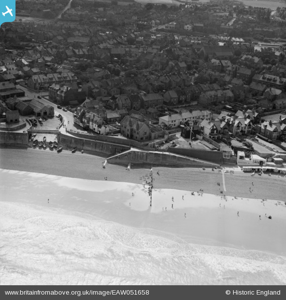
EAW051658 ENGLAND (1953). The town and seafront, Sheringham, 1953
© Copyright OpenStreetMap contributors and licensed by the OpenStreetMap Foundation. 2026. Cartography is licensed as CC BY-SA.
Nearby Images (13)
Details
| Title | [EAW051658] The town and seafront, Sheringham, 1953 |
| Reference | EAW051658 |
| Date | 26-August-1953 |
| Link | |
| Place name | SHERINGHAM |
| Parish | SHERINGHAM |
| District | |
| Country | ENGLAND |
| Easting / Northing | 615780, 343499 |
| Longitude / Latitude | 1.2119978113106, 52.945101581202 |
| National Grid Reference | TG158435 |
Pins

Chris Booty |
Sunday 29th of March 2020 02:48:46 PM | |

Muffet |
Wednesday 25th of November 2015 10:56:30 AM | |

Farrowbee |
Wednesday 1st of April 2015 05:28:33 PM | |

Farrowbee |
Wednesday 1st of April 2015 05:25:54 PM | |

Farrowbee |
Wednesday 1st of April 2015 05:24:11 PM | |

Farrowbee |
Wednesday 1st of April 2015 05:22:23 PM | |

Farrowbee |
Tuesday 31st of March 2015 09:00:03 PM | |

Farrowbee |
Tuesday 31st of March 2015 08:57:40 PM | |

Farrowbee |
Tuesday 31st of March 2015 08:55:31 PM | |

Farrowbee |
Sunday 29th of March 2015 11:13:38 AM |


![[EAW051658] The town and seafront, Sheringham, 1953](http://britainfromabove.org.uk/sites/all/libraries/aerofilms-images/public/100x100/EAW/051/EAW051658.jpg)
![[EPW021198] West Slipway and the seafront, Sheringham, 1928](http://britainfromabove.org.uk/sites/all/libraries/aerofilms-images/public/100x100/EPW/021/EPW021198.jpg)
![[EPW021197] West Slipway and the seafront, Sheringham, 1928](http://britainfromabove.org.uk/sites/all/libraries/aerofilms-images/public/100x100/EPW/021/EPW021197.jpg)
![[EPW001802] The Promenade at West Cliff Plain, Sheringham, 1920](http://britainfromabove.org.uk/sites/all/libraries/aerofilms-images/public/100x100/EPW/001/EPW001802.jpg)
![[EPW001803] The Grand Hotel and Promenade, Sheringham, 1920](http://britainfromabove.org.uk/sites/all/libraries/aerofilms-images/public/100x100/EPW/001/EPW001803.jpg)
![[EPW021200] West Slipway and the seafront, Sheringham, 1928](http://britainfromabove.org.uk/sites/all/libraries/aerofilms-images/public/100x100/EPW/021/EPW021200.jpg)
![[EAW051657] Burlington Hotel and the seafront, Sheringham, 1953](http://britainfromabove.org.uk/sites/all/libraries/aerofilms-images/public/100x100/EAW/051/EAW051657.jpg)
![[EAW051653] The town and seafront, Sheringham, 1953](http://britainfromabove.org.uk/sites/all/libraries/aerofilms-images/public/100x100/EAW/051/EAW051653.jpg)
![[EPW001805] The Grand Hotel and Esplanade, Sheringham, 1920](http://britainfromabove.org.uk/sites/all/libraries/aerofilms-images/public/100x100/EPW/001/EPW001805.jpg)
![[EPW016558] Church Street and the High Street area, Sheringham, 1926](http://britainfromabove.org.uk/sites/all/libraries/aerofilms-images/public/100x100/EPW/016/EPW016558.jpg)
![[EAW038318] The town, Sheringham, 1951. This image has been produced from a print.](http://britainfromabove.org.uk/sites/all/libraries/aerofilms-images/public/100x100/EAW/038/EAW038318.jpg)
![[EAW038319] Church Street and environs, Sheringham, 1951. This image has been produced from a print.](http://britainfromabove.org.uk/sites/all/libraries/aerofilms-images/public/100x100/EAW/038/EAW038319.jpg)
![[EPW016557] The Promenade and Beach Road area, Sheringham, 1926](http://britainfromabove.org.uk/sites/all/libraries/aerofilms-images/public/100x100/EPW/016/EPW016557.jpg)