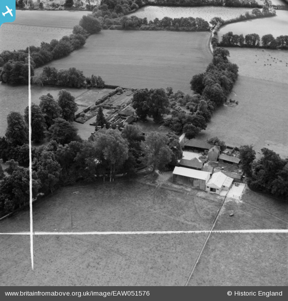
EAW051576 ENGLAND (1953). The Old House, Kingsclere, 1953. This image was marked by Aerofilms Ltd for photo editing.
© Copyright OpenStreetMap contributors and licensed by the OpenStreetMap Foundation. 2025. Cartography is licensed as CC BY-SA.
Nearby Images (11)
Details
| Title | [EAW051576] The Old House, Kingsclere, 1953. This image was marked by Aerofilms Ltd for photo editing. |
| Reference | EAW051576 |
| Date | 26-August-1953 |
| Link | |
| Place name | KINGSCLERE |
| Parish | KINGSCLERE |
| District | |
| Country | ENGLAND |
| Easting / Northing | 454497, 158068 |
| Longitude / Latitude | -1.2179049434666, 51.31860146861 |
| National Grid Reference | SU545581 |
Pins
Be the first to add a comment to this image!


![[EAW051576] The Old House, Kingsclere, 1953. This image was marked by Aerofilms Ltd for photo editing.](http://britainfromabove.org.uk/sites/all/libraries/aerofilms-images/public/100x100/EAW/051/EAW051576.jpg)
![[EAW051213] The Old House, Kingsclere, 1953. This image was marked by Aerofilms Ltd for photo editing.](http://britainfromabove.org.uk/sites/all/libraries/aerofilms-images/public/100x100/EAW/051/EAW051213.jpg)
![[EAW051578] The Old House and the surrounding countryside, Kingsclere, 1953. This image was marked by Aerofilms Ltd for photo editing.](http://britainfromabove.org.uk/sites/all/libraries/aerofilms-images/public/100x100/EAW/051/EAW051578.jpg)
![[EAW051212] The Old House, Kingsclere, 1953. This image was marked by Aerofilms Ltd for photo editing.](http://britainfromabove.org.uk/sites/all/libraries/aerofilms-images/public/100x100/EAW/051/EAW051212.jpg)
![[EAW051209] The Old House, Kingsclere, 1953](http://britainfromabove.org.uk/sites/all/libraries/aerofilms-images/public/100x100/EAW/051/EAW051209.jpg)
![[EAW051211] The Old House, Kingsclere, 1953. This image was marked by Aerofilms Ltd for photo editing.](http://britainfromabove.org.uk/sites/all/libraries/aerofilms-images/public/100x100/EAW/051/EAW051211.jpg)
![[EAW051210] The Old House, Kingsclere, 1953. This image was marked by Aerofilms Ltd for photo editing.](http://britainfromabove.org.uk/sites/all/libraries/aerofilms-images/public/100x100/EAW/051/EAW051210.jpg)
![[EAW051577] The Old House, Kingsclere, 1953. This image was marked by Aerofilms Ltd for photo editing.](http://britainfromabove.org.uk/sites/all/libraries/aerofilms-images/public/100x100/EAW/051/EAW051577.jpg)
![[EAW051207] The Old House, Kingsclere, 1953. This image was marked by Aerofilms Ltd for photo editing.](http://britainfromabove.org.uk/sites/all/libraries/aerofilms-images/public/100x100/EAW/051/EAW051207.jpg)
![[EAW051579] The Old House, Kingsclere, 1953. This image was marked by Aerofilms Ltd for photo editing.](http://britainfromabove.org.uk/sites/all/libraries/aerofilms-images/public/100x100/EAW/051/EAW051579.jpg)
![[EAW051208] The Old House and surrounding countryside, Kingsclere, from the south, 1953](http://britainfromabove.org.uk/sites/all/libraries/aerofilms-images/public/100x100/EAW/051/EAW051208.jpg)