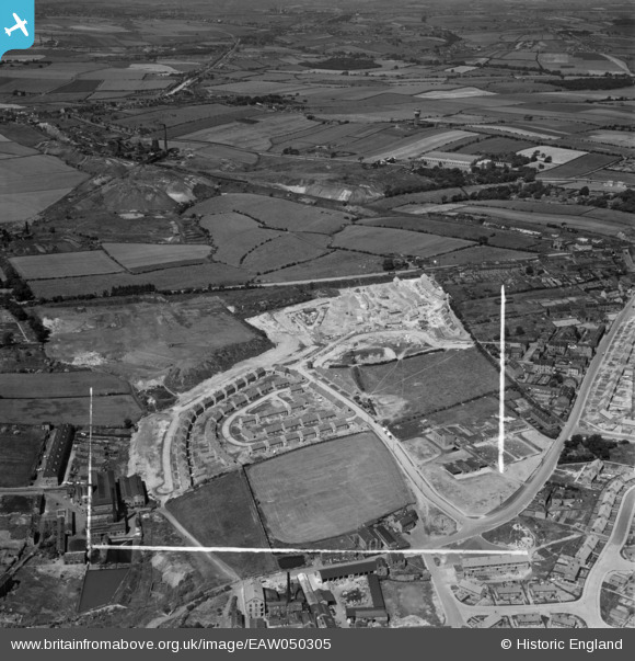
EAW050305 ENGLAND (1953). Housing estate under construction to the south of Wakefield Road, Dewsbury, 1953. This image was marked by Aerofilms Ltd for photo editing.
© Copyright OpenStreetMap contributors and licensed by the OpenStreetMap Foundation. 2026. Cartography is licensed as CC BY-SA.
Nearby Images (8)
Details
| Title | [EAW050305] Housing estate under construction to the south of Wakefield Road, Dewsbury, 1953. This image was marked by Aerofilms Ltd for photo editing. |
| Reference | EAW050305 |
| Date | 3-July-1953 |
| Link | |
| Place name | DEWSBURY |
| Parish | |
| District | |
| Country | ENGLAND |
| Easting / Northing | 426408, 421709 |
| Longitude / Latitude | -1.6000459969656, 53.690933450906 |
| National Grid Reference | SE264217 |
Pins

Michael |
Tuesday 12th of November 2019 02:03:36 PM |


![[EAW050305] Housing estate under construction to the south of Wakefield Road, Dewsbury, 1953. This image was marked by Aerofilms Ltd for photo editing.](http://britainfromabove.org.uk/sites/all/libraries/aerofilms-images/public/100x100/EAW/050/EAW050305.jpg)
![[EAW050302] Housing estate under construction to the south of Wakefield Road, Dewsbury, 1953. This image was marked by Aerofilms Ltd for photo editing.](http://britainfromabove.org.uk/sites/all/libraries/aerofilms-images/public/100x100/EAW/050/EAW050302.jpg)
![[EAW050306] Housing estate under construction to the south of Wakefield Road, Dewsbury, 1953. This image was marked by Aerofilms Ltd for photo editing.](http://britainfromabove.org.uk/sites/all/libraries/aerofilms-images/public/100x100/EAW/050/EAW050306.jpg)
![[EAW050309] Housing estate under construction to the south of Wakefield Road, Dewsbury, 1953. This image was marked by Aerofilms Ltd for photo editing.](http://britainfromabove.org.uk/sites/all/libraries/aerofilms-images/public/100x100/EAW/050/EAW050309.jpg)
![[EAW050304] Housing estate under construction to the south of Wakefield Road, Dewsbury, 1953. This image was marked by Aerofilms Ltd for photo editing.](http://britainfromabove.org.uk/sites/all/libraries/aerofilms-images/public/100x100/EAW/050/EAW050304.jpg)
![[EAW050303] Housing estate under construction to the south of Wakefield Road, Dewsbury, 1953. This image was marked by Aerofilms Ltd for photo editing.](http://britainfromabove.org.uk/sites/all/libraries/aerofilms-images/public/100x100/EAW/050/EAW050303.jpg)
![[EAW050308] Housing estate under construction between Wakefield Road and the Chickenley Estate, Dewsbury, 1953. This image was marked by Aerofilms Ltd for photo editing.](http://britainfromabove.org.uk/sites/all/libraries/aerofilms-images/public/100x100/EAW/050/EAW050308.jpg)
![[EAW050307] Housing estate under construction between Wakefield Road and the Chickenley Estate, Dewsbury, 1953. This image was marked by Aerofilms Ltd for photo editing.](http://britainfromabove.org.uk/sites/all/libraries/aerofilms-images/public/100x100/EAW/050/EAW050307.jpg)