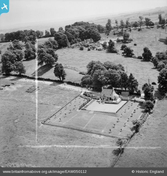
EAW050112 ENGLAND (1953). Foxborough and environs, Weston-sub-Edge, from the north-west, 1953. This image was marked by Aerofilms Ltd for photo editing.
© Copyright OpenStreetMap contributors and licensed by the OpenStreetMap Foundation. 2025. Cartography is licensed as CC BY-SA.
Nearby Images (9)
Details
| Title | [EAW050112] Foxborough and environs, Weston-sub-Edge, from the north-west, 1953. This image was marked by Aerofilms Ltd for photo editing. |
| Reference | EAW050112 |
| Date | 26-June-1953 |
| Link | |
| Place name | WESTON-SUB-EDGE |
| Parish | WESTON SUBEDGE |
| District | |
| Country | ENGLAND |
| Easting / Northing | 413339, 239696 |
| Longitude / Latitude | -1.8054395056873, 52.055068834255 |
| National Grid Reference | SP133397 |
Pins
Be the first to add a comment to this image!


![[EAW050112] Foxborough and environs, Weston-sub-Edge, from the north-west, 1953. This image was marked by Aerofilms Ltd for photo editing.](http://britainfromabove.org.uk/sites/all/libraries/aerofilms-images/public/100x100/EAW/050/EAW050112.jpg)
![[EAW050117] Foxborough, Weston-sub-Edge, 1953. This image was marked by Aerofilms Ltd for photo editing.](http://britainfromabove.org.uk/sites/all/libraries/aerofilms-images/public/100x100/EAW/050/EAW050117.jpg)
![[EAW050113] Foxborough, Weston-sub-Edge, 1953. This image was marked by Aerofilms Ltd for photo editing.](http://britainfromabove.org.uk/sites/all/libraries/aerofilms-images/public/100x100/EAW/050/EAW050113.jpg)
![[EAW050111] Fields by Knapp Farm House, Weston-sub-Edge, 1953. This image was marked by Aerofilms Ltd for photo editing.](http://britainfromabove.org.uk/sites/all/libraries/aerofilms-images/public/100x100/EAW/050/EAW050111.jpg)
![[EAW050110] Fields by Knapp Farm House, Weston-sub-Edge, 1953. This image was marked by Aerofilms Ltd for photo editing.](http://britainfromabove.org.uk/sites/all/libraries/aerofilms-images/public/100x100/EAW/050/EAW050110.jpg)
![[EAW050109] Ledge Plantation and Dover's Hill, Weston-sub-Edge, 1953. This image was marked by Aerofilms Ltd for photo editing.](http://britainfromabove.org.uk/sites/all/libraries/aerofilms-images/public/100x100/EAW/050/EAW050109.jpg)
![[EAW050114] Knapp Farm House and environs, Weston-sub-Edge, from the south-west, 1953. This image was marked by Aerofilms Ltd for photo editing.](http://britainfromabove.org.uk/sites/all/libraries/aerofilms-images/public/100x100/EAW/050/EAW050114.jpg)
![[EAW050116] Knapp Farm House, Weston-sub-Edge, 1953. This image was marked by Aerofilms Ltd for photo editing.](http://britainfromabove.org.uk/sites/all/libraries/aerofilms-images/public/100x100/EAW/050/EAW050116.jpg)
![[EAW050115] Knapp Farm House, Weston-sub-Edge, 1953. This image was marked by Aerofilms Ltd for photo editing.](http://britainfromabove.org.uk/sites/all/libraries/aerofilms-images/public/100x100/EAW/050/EAW050115.jpg)