
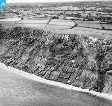
EAW050070 ENGLAND (1953). Cultivation plots (plats) on the cliffs near Branscombe Ebb, Branscombe, 1953

© Copyright OpenStreetMap contributors and licensed by the OpenStreetMap Foundation. 2026. Cartography is licensed as CC BY-SA.
Details
| Title | [EAW050070] Cultivation plots (plats) on the cliffs near Branscombe Ebb, Branscombe, 1953 |
| Reference | EAW050070 |
| Date | 25-June-1953 |
| Link | |
| Place name | BRANSCOMBE |
| Parish | BRANSCOMBE |
| District | |
| Country | ENGLAND |
| Easting / Northing | 318778, 88057 |
| Longitude / Latitude | -3.1498900020879, 50.685913359364 |
| National Grid Reference | SY188881 |
Pins

JMB |
Saturday 25th of April 2015 07:31:48 PM |
User Comment Contributions
RAF Branscombe WWII Chain Home radar station? |
JMB |
Saturday 25th of April 2015 07:32:04 PM |