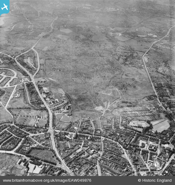
EAW049876 ENGLAND (1953). The site for Russells Hall Estate at the former Old Park Colliery, Dudley, 1953
© Copyright OpenStreetMap contributors and licensed by the OpenStreetMap Foundation. 2026. Cartography is licensed as CC BY-SA.
Details
| Title | [EAW049876] The site for Russells Hall Estate at the former Old Park Colliery, Dudley, 1953 |
| Reference | EAW049876 |
| Date | 11-June-1953 |
| Link | |
| Place name | DUDLEY |
| Parish | |
| District | |
| Country | ENGLAND |
| Easting / Northing | 393105, 289858 |
| Longitude / Latitude | -2.101595814421, 52.506207989264 |
| National Grid Reference | SO931899 |
Pins

Steve Nicholls |
Monday 7th of September 2015 05:13:16 PM | |

Steve Nicholls |
Monday 7th of September 2015 05:12:07 PM | |

Steve Nicholls |
Monday 7th of September 2015 05:10:51 PM | |

stephen |
Thursday 11th of December 2014 05:25:59 PM | |

stephen |
Thursday 11th of December 2014 05:24:54 PM | |

stephen |
Thursday 11th of December 2014 05:23:40 PM | |

stephen |
Thursday 11th of December 2014 05:18:37 PM | |

Davidh |
Tuesday 2nd of December 2014 08:23:40 PM | |

The Circles |
Friday 4th of July 2014 11:29:44 PM |
User Comment Contributions
Entrance to Dudley Canal Tunnel. |

The Circles |
Friday 4th of July 2014 11:27:55 PM |


![[EAW049876] The site for Russells Hall Estate at the former Old Park Colliery, Dudley, 1953](http://britainfromabove.org.uk/sites/all/libraries/aerofilms-images/public/100x100/EAW/049/EAW049876.jpg)
![[EAW049877] The site for Russells Hall Estate at the former Old Park Colliery, Dudley, 1953](http://britainfromabove.org.uk/sites/all/libraries/aerofilms-images/public/100x100/EAW/049/EAW049877.jpg)
![[EAW049878] The site for Russells Hall Estate at the former Old Park Colliery, Dudley, 1953](http://britainfromabove.org.uk/sites/all/libraries/aerofilms-images/public/100x100/EAW/049/EAW049878.jpg)
![[EAW049874] The site for Russells Hall Estate at the former Old Park Colliery, Dudley, 1953](http://britainfromabove.org.uk/sites/all/libraries/aerofilms-images/public/100x100/EAW/049/EAW049874.jpg)