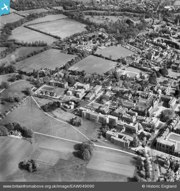
EAW049090 ENGLAND (1953). University buildings off South Parks Road, Oxford, 1953
© Copyright OpenStreetMap contributors and licensed by the OpenStreetMap Foundation. 2026. Cartography is licensed as CC BY-SA.
Nearby Images (9)
Details
| Title | [EAW049090] University buildings off South Parks Road, Oxford, 1953 |
| Reference | EAW049090 |
| Date | 5-May-1953 |
| Link | |
| Place name | OXFORD |
| Parish | |
| District | |
| Country | ENGLAND |
| Easting / Northing | 451648, 206978 |
| Longitude / Latitude | -1.2516087698798, 51.758650747894 |
| National Grid Reference | SP516070 |
Pins
Be the first to add a comment to this image!


![[EAW049090] University buildings off South Parks Road, Oxford, 1953](http://britainfromabove.org.uk/sites/all/libraries/aerofilms-images/public/100x100/EAW/049/EAW049090.jpg)
![[EAW049083] Keble College, University Parks and university buildings off South Parks Road, Oxford, 1953](http://britainfromabove.org.uk/sites/all/libraries/aerofilms-images/public/100x100/EAW/049/EAW049083.jpg)
![[EAW049266] The University Museum, Pitt Rivers Museum, University Observatory and environs, Oxford, 1953](http://britainfromabove.org.uk/sites/all/libraries/aerofilms-images/public/100x100/EAW/049/EAW049266.jpg)
![[EAW003117] Oxford, The Oxford Colleges and crowds gathered for the opening of the New Bodleian Library by King George VI, 1946](http://britainfromabove.org.uk/sites/all/libraries/aerofilms-images/public/100x100/EAW/003/EAW003117.jpg)
![[EPW000830] View over Oxford from Radcliffe Science Library, Oxford, from the north, 1920](http://britainfromabove.org.uk/sites/all/libraries/aerofilms-images/public/100x100/EPW/000/EPW000830.jpg)
![[EPW038411] The University Parks, Oxford, 1932](http://britainfromabove.org.uk/sites/all/libraries/aerofilms-images/public/100x100/EPW/038/EPW038411.jpg)
![[EAW045714] University Museum (site of) and part of Keble College, Oxford, 1952. This image has been produced from a damaged negative.](http://britainfromabove.org.uk/sites/all/libraries/aerofilms-images/public/100x100/EAW/045/EAW045714.jpg)
![[EPW022532] The Pitt Rivers Museum and the city, Oxford, from the north-east, 1928](http://britainfromabove.org.uk/sites/all/libraries/aerofilms-images/public/100x100/EPW/022/EPW022532.jpg)
![[EPW022523] Keble College and the Pitt Rivers Museum, Oxford, 1928](http://britainfromabove.org.uk/sites/all/libraries/aerofilms-images/public/100x100/EPW/022/EPW022523.jpg)