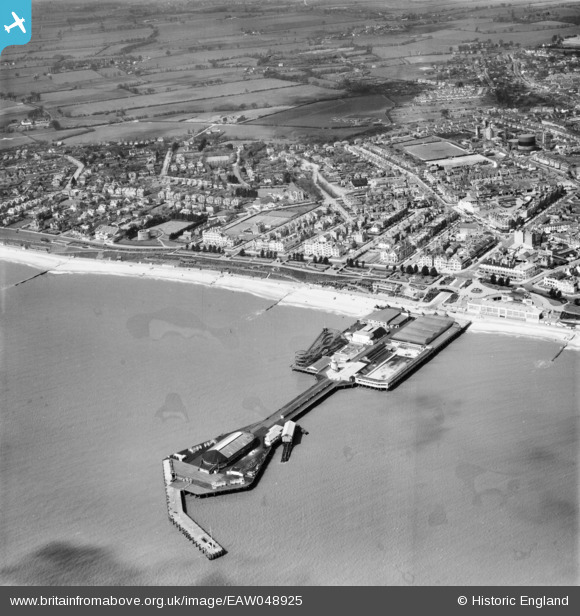
EAW048925 ENGLAND (1953). The pier and the town, Clacton-on-Sea, 1953
© Copyright OpenStreetMap contributors and licensed by the OpenStreetMap Foundation. 2026. Cartography is licensed as CC BY-SA.
Nearby Images (48)
Details
| Title | [EAW048925] The pier and the town, Clacton-on-Sea, 1953 |
| Reference | EAW048925 |
| Date | 2-May-1953 |
| Link | |
| Place name | CLACTON-ON-SEA |
| Parish | |
| District | |
| Country | ENGLAND |
| Easting / Northing | 617572, 214373 |
| Longitude / Latitude | 1.1548696590832, 51.785190417937 |
| National Grid Reference | TM176144 |
Pins

Stephen Mirrington |
Wednesday 8th of October 2025 11:20:40 AM | |

Stephen Mirrington |
Wednesday 8th of October 2025 11:17:52 AM | |

Stephen Mirrington |
Wednesday 8th of October 2025 11:16:47 AM | |

Stephen Mirrington |
Wednesday 8th of October 2025 11:15:12 AM |


![[EAW048925] The pier and the town, Clacton-on-Sea, 1953](http://britainfromabove.org.uk/sites/all/libraries/aerofilms-images/public/100x100/EAW/048/EAW048925.jpg)
![[EPW058724] The Seafront Gardens and environs, Clacton-On-Sea, 1938. This image has been produced from a copy-negative.](http://britainfromabove.org.uk/sites/all/libraries/aerofilms-images/public/100x100/EPW/058/EPW058724.jpg)
![[EAW038332] Holiday-makers on the beach in front of Seafront Gardens, Clacton-On-Sea, 1951. This image has been produced from a print.](http://britainfromabove.org.uk/sites/all/libraries/aerofilms-images/public/100x100/EAW/038/EAW038332.jpg)
![[EPW001994] General view of the town and pier, Clacton-on-Sea, 1920](http://britainfromabove.org.uk/sites/all/libraries/aerofilms-images/public/100x100/EPW/001/EPW001994.jpg)
![[EPW011620] The Seafront Gardens and environs, Clacton-On-Sea, 1924. This image has been produced from a copy-negative.](http://britainfromabove.org.uk/sites/all/libraries/aerofilms-images/public/100x100/EPW/011/EPW011620.jpg)
![[EPW058728] Marine Parade East, the seafront and town, Clacton-On-Sea, from the south, 1938. This image has been produced from a copy-negative.](http://britainfromabove.org.uk/sites/all/libraries/aerofilms-images/public/100x100/EPW/058/EPW058728.jpg)
![[EPW039151] The pier and Marine Parade East, Clacton-On-Sea, 1932. This image has been produced from a print.](http://britainfromabove.org.uk/sites/all/libraries/aerofilms-images/public/100x100/EPW/039/EPW039151.jpg)
![[EPW039154] The pier and Marine Parade East, Clacton-on-Sea, 1932](http://britainfromabove.org.uk/sites/all/libraries/aerofilms-images/public/100x100/EPW/039/EPW039154.jpg)
![[EPW001992] General view of the town and the pier, Clacton-on-Sea, 1920](http://britainfromabove.org.uk/sites/all/libraries/aerofilms-images/public/100x100/EPW/001/EPW001992.jpg)
![[EPW039152] The pier and Clacton Seafront Gardens, Clacton-On-Sea, 1932. This image has been produced from a print.](http://britainfromabove.org.uk/sites/all/libraries/aerofilms-images/public/100x100/EPW/039/EPW039152.jpg)
![[EPW039150] The pier, pavilion and environs, Clacton-On-Sea, 1932. This image has been produced from a copy-negative.](http://britainfromabove.org.uk/sites/all/libraries/aerofilms-images/public/100x100/EPW/039/EPW039150.jpg)
![[EPW046896] The Pier and the seafront, Clacton-on-Sea, from the south-west, 1935](http://britainfromabove.org.uk/sites/all/libraries/aerofilms-images/public/100x100/EPW/046/EPW046896.jpg)
![[EPW039148] The swimming pool on Clacton Pier, Clacton-On-Sea, 1932. This image has been produced from a print.](http://britainfromabove.org.uk/sites/all/libraries/aerofilms-images/public/100x100/EPW/039/EPW039148.jpg)
![[EPW039143] The swimming pool on Clacton Pier, Clacton-On-Sea, 1932. This image has been produced from a damaged print.](http://britainfromabove.org.uk/sites/all/libraries/aerofilms-images/public/100x100/EPW/039/EPW039143.jpg)
![[EPW041340] The swimming pool on the Pier, Clacton-On-Sea, 1933](http://britainfromabove.org.uk/sites/all/libraries/aerofilms-images/public/100x100/EPW/041/EPW041340.jpg)
![[EPW011619] Pier Avenue and environs, Clacton-On-Sea, 1924. This image has been produced from a print.](http://britainfromabove.org.uk/sites/all/libraries/aerofilms-images/public/100x100/EPW/011/EPW011619.jpg)
![[EPW039142] The pier, Clacton-on-Sea, 1932](http://britainfromabove.org.uk/sites/all/libraries/aerofilms-images/public/100x100/EPW/039/EPW039142.jpg)
![[EPW039146] The swimming pool on Clacton Pier, Clacton-On-Sea, 1932. This image has been produced from a print.](http://britainfromabove.org.uk/sites/all/libraries/aerofilms-images/public/100x100/EPW/039/EPW039146.jpg)
![[EPW041338] The Pier, Clacton-On-Sea, from the south-west, 1933](http://britainfromabove.org.uk/sites/all/libraries/aerofilms-images/public/100x100/EPW/041/EPW041338.jpg)
![[EPW058704] The pier, Clacton-on-Sea, 1938](http://britainfromabove.org.uk/sites/all/libraries/aerofilms-images/public/100x100/EPW/058/EPW058704.jpg)
![[EPW039124] The pier and the town, Clacton-on-Sea, from the south, 1932](http://britainfromabove.org.uk/sites/all/libraries/aerofilms-images/public/100x100/EPW/039/EPW039124.jpg)
![[EPW039140] The swimming pool on Clacton Pier, Clacton-on-Sea, 1932](http://britainfromabove.org.uk/sites/all/libraries/aerofilms-images/public/100x100/EPW/039/EPW039140.jpg)
![[EPW041339] The swimming pool on the Pier, Clacton-On-Sea, 1933](http://britainfromabove.org.uk/sites/all/libraries/aerofilms-images/public/100x100/EPW/041/EPW041339.jpg)
![[EAW030582] Clacton Pier and the beach, Clacton-On-Sea, 1950. This image was marked by Aerofilms Ltd for photo editing.](http://britainfromabove.org.uk/sites/all/libraries/aerofilms-images/public/100x100/EAW/030/EAW030582.jpg)
![[EPW011623] Pier Gap and environs, Clacton-On-Sea, 1924. This image has been produced from a copy-negative.](http://britainfromabove.org.uk/sites/all/libraries/aerofilms-images/public/100x100/EPW/011/EPW011623.jpg)
![[EPW041341] The swimming pool on the Pier, Clacton-On-Sea, 1933](http://britainfromabove.org.uk/sites/all/libraries/aerofilms-images/public/100x100/EPW/041/EPW041341.jpg)
![[EPW039134] The pier and the town, Clacton-on-Sea, 1932](http://britainfromabove.org.uk/sites/all/libraries/aerofilms-images/public/100x100/EPW/039/EPW039134.jpg)
![[EPW041335] The Pier, Clacton-On-Sea, 1933](http://britainfromabove.org.uk/sites/all/libraries/aerofilms-images/public/100x100/EPW/041/EPW041335.jpg)
![[EPW039155] The Beaumont Hall Hotel, Clacton-on-Sea, 1932](http://britainfromabove.org.uk/sites/all/libraries/aerofilms-images/public/100x100/EPW/039/EPW039155.jpg)
![[EPW042614] A Paddle Steamer berthed at the Pier, Clacton-On-Sea, 1933](http://britainfromabove.org.uk/sites/all/libraries/aerofilms-images/public/100x100/EPW/042/EPW042614.jpg)
![[EPW039121] The pier and the town, Clacton-on-Sea, 1932](http://britainfromabove.org.uk/sites/all/libraries/aerofilms-images/public/100x100/EPW/039/EPW039121.jpg)
![[EPW041333] The Pier, Clacton-On-Sea, 1933](http://britainfromabove.org.uk/sites/all/libraries/aerofilms-images/public/100x100/EPW/041/EPW041333.jpg)
![[EPW042615] A Paddle Steamer berthed at the Pier, Clacton-On-Sea, 1933](http://britainfromabove.org.uk/sites/all/libraries/aerofilms-images/public/100x100/EPW/042/EPW042615.jpg)
![[EPW039141] The swimming pool on Clacton Pier, Clacton-on-Sea, 1932](http://britainfromabove.org.uk/sites/all/libraries/aerofilms-images/public/100x100/EPW/039/EPW039141.jpg)
![[EPW039128] The pier and the town, Clacton-on-Sea, 1932](http://britainfromabove.org.uk/sites/all/libraries/aerofilms-images/public/100x100/EPW/039/EPW039128.jpg)
![[EPW039120] The pier, Clacton-on-Sea, 1932](http://britainfromabove.org.uk/sites/all/libraries/aerofilms-images/public/100x100/EPW/039/EPW039120.jpg)
![[EAW038331] The Pavilion at Pier Gap, Clacton-On-Sea, 1951. This image has been produced from a print.](http://britainfromabove.org.uk/sites/all/libraries/aerofilms-images/public/100x100/EAW/038/EAW038331.jpg)
![[EPW039125] The pier and the town, Clacton-on-Sea, from the south, 1932](http://britainfromabove.org.uk/sites/all/libraries/aerofilms-images/public/100x100/EPW/039/EPW039125.jpg)
![[EPW049300] The Pavilion alongside Pier Gap, Clacton-On-Sea, 1935. This image has been produced from a copy-negative.](http://britainfromabove.org.uk/sites/all/libraries/aerofilms-images/public/100x100/EPW/049/EPW049300.jpg)
![[EPW039139] The Pavilion, Clacton-on-Sea, 1932](http://britainfromabove.org.uk/sites/all/libraries/aerofilms-images/public/100x100/EPW/039/EPW039139.jpg)
![[EPW039158] The flagstaff beside Pier Gap, Clacton-On-Sea, 1932. This image has been produced from a damaged print.](http://britainfromabove.org.uk/sites/all/libraries/aerofilms-images/public/100x100/EPW/039/EPW039158.jpg)
![[EPW058725] The Pavilion, Clacton-On-Sea, 1938. This image has been produced from a copy-negative.](http://britainfromabove.org.uk/sites/all/libraries/aerofilms-images/public/100x100/EPW/058/EPW058725.jpg)
![[EPW011616] The Band Pavilion, Clacton-On-Sea, 1924. This image has been produced from a copy-negative.](http://britainfromabove.org.uk/sites/all/libraries/aerofilms-images/public/100x100/EPW/011/EPW011616.jpg)
![[EPW039138] The Pavilion, Clacton-on-Sea, 1932](http://britainfromabove.org.uk/sites/all/libraries/aerofilms-images/public/100x100/EPW/039/EPW039138.jpg)
![[EPW001870] View of Clacton-on-Sea, pier and Martello Tower, Clacton-on-Sea, 1920](http://britainfromabove.org.uk/sites/all/libraries/aerofilms-images/public/100x100/EPW/001/EPW001870.jpg)
![[EPW039129] The pier and the town, Clacton-on-Sea, from the south-east, 1932](http://britainfromabove.org.uk/sites/all/libraries/aerofilms-images/public/100x100/EPW/039/EPW039129.jpg)
![[EAW048924] Martello Tower Number 6 and the town, Clacton-on-Sea, from the south-east, 1953](http://britainfromabove.org.uk/sites/all/libraries/aerofilms-images/public/100x100/EAW/048/EAW048924.jpg)
![[EPW011621] Beatrice Road and environs, Clacton-On-Sea, 1924. This image has been produced from a copy-negative.](http://britainfromabove.org.uk/sites/all/libraries/aerofilms-images/public/100x100/EPW/011/EPW011621.jpg)