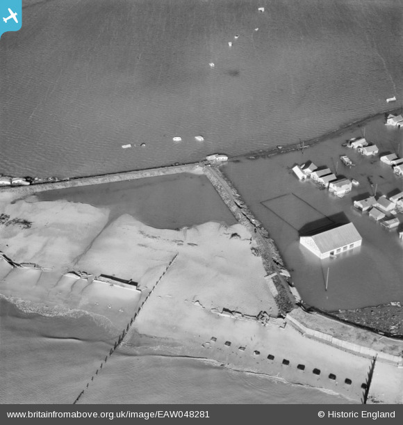
EAW048281 ENGLAND (1953). Damaged sea defences and flooding around the Amusementt Arcade and Roller Skating Rink, Jaywick, 1953
    © Copyright OpenStreetMap contributors and licensed by the OpenStreetMap Foundation. 2025. Cartography is licensed as CC BY-SA.
  
Details
| Title | [EAW048281] Damaged sea defences and flooding around the Amusementt Arcade and Roller Skating Rink, Jaywick, 1953 | 
| Reference | EAW048281 | 
| Date | 2-March-1953 | 
| Link | |
| Place name | JAYWICK | 
| Parish | |
| District | |
| Country | ENGLAND | 
| Easting / Northing | 613829, 212769 | 
| Longitude / Latitude | 1.0996933490767, 51.772231155454 | 
| National Grid Reference | TM138128 | 
Pins
|  WW2 Anti-Tank Obstacles Cubes TBC |   Sparky | Wednesday 25th of October 2017 07:00:03 PM | 
 
             
  ![[EAW048281] Damaged sea defences and flooding around the Amusementt Arcade and Roller Skating Rink, Jaywick, 1953](http://britainfromabove.org.uk/sites/all/libraries/aerofilms-images/public/100x100/EAW/048/EAW048281.jpg) 
  
                                          ![[EAW048267] Flooding at Belsize Avenue, Lincoln Avenue and Napier Avenue, Jaywick, 1953](http://britainfromabove.org.uk/sites/all/libraries/aerofilms-images/public/100x100/EAW/048/EAW048267.jpg) 
 ![[EAW048282] Caravans and debris washed up against the inside of the sea wall east and west of Martello Tower C, Jaywick, 1953](http://britainfromabove.org.uk/sites/all/libraries/aerofilms-images/public/100x100/EAW/048/EAW048282.jpg) 
 ![[EAW048271] Flooding between Daimler Avenue and Crossley Avenue and beyond, Jaywick, 1953](http://britainfromabove.org.uk/sites/all/libraries/aerofilms-images/public/100x100/EAW/048/EAW048271.jpg)