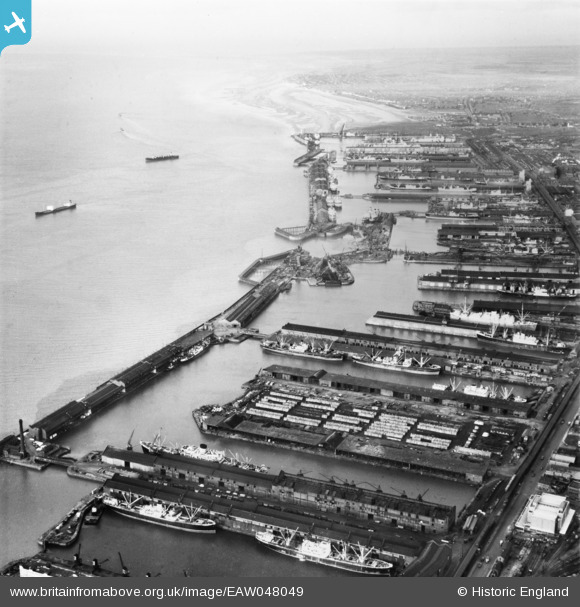
EAW048049 ENGLAND (1952). The Port of Liverpool from Huskisson Dock to Gladstone Dock, Sandhills, from the south-east, 1952
© Copyright OpenStreetMap contributors and licensed by the OpenStreetMap Foundation. 2026. Cartography is licensed as CC BY-SA.
Nearby Images (6)
Details
| Title | [EAW048049] The Port of Liverpool from Huskisson Dock to Gladstone Dock, Sandhills, from the south-east, 1952 |
| Reference | EAW048049 |
| Date | 12-December-1952 |
| Link | |
| Place name | SANDHILLS |
| Parish | |
| District | |
| Country | ENGLAND |
| Easting / Northing | 333509, 393121 |
| Longitude / Latitude | -3.0008627647344, 53.430420057164 |
| National Grid Reference | SJ335931 |
Pins
Be the first to add a comment to this image!


![[EAW048049] The Port of Liverpool from Huskisson Dock to Gladstone Dock, Sandhills, from the south-east, 1952](http://britainfromabove.org.uk/sites/all/libraries/aerofilms-images/public/100x100/EAW/048/EAW048049.jpg)
![[EPW023590] Huskisson Docks, Sandhills, 1928](http://britainfromabove.org.uk/sites/all/libraries/aerofilms-images/public/100x100/EPW/023/EPW023590.jpg)
![[EPW005046] Huskisson Dock, Liverpool, 1920](http://britainfromabove.org.uk/sites/all/libraries/aerofilms-images/public/100x100/EPW/005/EPW005046.jpg)
![[EPW018899] Sandon and Huskisson Docks, Sandhills, 1927](http://britainfromabove.org.uk/sites/all/libraries/aerofilms-images/public/100x100/EPW/018/EPW018899.jpg)
![[EAW023370] Sandon Dock and Sandon Half Tide Dock, Liverpool, 1949](http://britainfromabove.org.uk/sites/all/libraries/aerofilms-images/public/100x100/EAW/023/EAW023370.jpg)
![[EAW001920] The Liverpool Docks at Sandhills and Bootle, Liverpool, from the south, 1946](http://britainfromabove.org.uk/sites/all/libraries/aerofilms-images/public/100x100/EAW/001/EAW001920.jpg)